Trenton Township Zoning Code
ARTICLE 1 – TITLE, PURPOSE, INTERPRETATION, & JURISDICTION
1.01 TITLE
a) This Zoning Code shall be known and may be cited as the “Trenton Township Zoning Resolution.”
b) This Zoning Code may also be known as the “Resolution” or the “Code.”
c) Unless otherwise provided herein or by the law or implication thereof, the same rules of construction, definition, and application shall govern the interpretation of this Code as those governing the interpretation of the Ohio Revised Code (ORC).
1.02 PURPOSE
This is a Zoning Resolution for Trenton Township, Delaware County, Ohio adopted and amended under Chapter 519 of the ORC for the following purposes, among others:
a) To promote and protect the health, safety, morals, and general welfare of the present and future inhabitants of Trenton Township;
b) To protect the quality of life within Trenton Township through the protection of the total environment, the prevention of nuisances and hazards, and the provision of adequate light, air, and convenient access to property;
c) To ensure the compatibility of land uses which are either adjacent or in proximity to each other;
d) To promote, insure, and control the orderly development of all lands within the Township to its appropriate use;
e) To promote and secure the most appropriate use of land to facilitate and provide adequate public and private improvements;
f) To conserve and protect the natural resources, scenic areas, wildlife habitat, and the historical and unique natural features of the land; and
g) To recognize and protect the right to farm all suitable land in Trenton Township. The right to farm includes the use of large irrigation pumps and equipment, aerial and ground seeding and spraying, large tractors and agricultural implements, and the application of fertilizers, insecticides, pesticides, and herbicides. When conducted under generally accepted agricultural practices, farming may occur at any time and on any day, and the noise, odors, dust, and fumes necessarily associated with such a use are expressly permitted as part of the exercise of the right to farm.
1.03 INTERPRETATION
a) The provisions of this Code shall be held as the minimum requirements, adopted for the promotion of public health, safety, and general welfare.
b) It is not intended that the Code shall repeal, annul, or interfere with any easements, covenants, or other agreements between parties unless they violate this Code. When a provision of this Code conflicts with any other lawfully adopted rules, regulations, or ordinances, or resolutions, the most restrictive (imposing the higher standards) shall apply.
1.04 APPLICABILITY
The regulations set forth in this Code shall be applicable to all buildings, structures, uses, and lands owned or controlled by any individual, organization, political subdivisions, district, taxing unit, or bond-issuing authority located within the jurisdiction boundaries (the unincorporated area of Trenton Township, Delaware County, Ohio), and any additional lands under future zoning or subdivision plans for the jurisdiction.
1.05 SEPARABILITY
The invalidation of any clause, sentence, paragraph, or section of this Code by a court of competent jurisdiction shall not affect the validity of the remainder of this Code either in whole or in part.
1.06 PREVIOUS COMMERCIAL LAND USE
Any land previously zoned as Commercial District (C) from the previous Code(s) shall be considered zoned under Community Business District (CB) to carry forth the same uses permitted for the specific district as outlined in the previous Code.
1.07 AGRICULTURE
Except for lands developed under ORC 519.21(B), nothing contained in this Resolution shall prohibit the use of any land for agricultural purposes or the construction or use of buildings or structures incident to the use for agricultural purposes of the land on which such buildings or structures are located, and no Zoning Certificate shall be required for any such use, building or structure. All such structures, however, shall conform to the yard and setback requirements of this resolution and other applicable laws and regulations.
Section 519.21(B) of the Ohio Revised Code allows a township zoning resolution, or an amendment thereof, to regulate agricultural use within any platted subdivision approved under Section 711.05, 711.09, or 711.10 of the Ohio Revised Code, or any area consisting of fifteen (15) or more lots approved under Section 711.131 (711.13.1) of the Ohio Revised Code, that are contiguous to one another and adjacent to one another and adjacent to one side of a dedicated public road, and the balance of which are contiguous to one another and adjacent to the opposite side of the same public road.
Pursuant to Section 519.21(B) of the Ohio Revised Code, animal, and/or poultry husbandry, including the raising, boarding, housing, or grazing of horses, cattle, sheep, goats, swine, poultry, or similar animals shall not be permitted on lots meeting the standards of ORC 519.21(B) above, and which are also one (1) acre or less in size. The processing of any such animals or their products shall also not be permitted.
Dairying and animal and/or poultry husbandry shall not be permitted on lots greater than one (1) acre but not greater than five (5) acres if such lots meet the standards of ORC 519.21(B) above, and if at least thirty-five percent (35%) of the lots in the subdivision are developed with at least one (1) building, structure, or improvement that is subject to real property taxation or that is subject to the tax on manufactured homes pursuant to Section 4503.06 of the Ohio Revised Code. After thirty-five percent (35%) of the lots are so developed, any existing animal and/or poultry husbandry operation shall be considered a Non-Conforming Use pursuant to Article 4.
1.08 PERMANENTLY SITED MANUFACTURED HOMES
Permanently Sited Manufactured Homes, as defined in Article 18 - Definitions, shall be considered a permitted use in any district that permits Single-Family Dwellings.
1.09 PUBLIC UTILITIES & RAILROADS
Nothing contained in this Resolution shall prevent the location, erection, construction, reconstruction, change, alteration, maintenance, removal, use or enlargement of any building or structure of any public utility or railroad, whether publicly or privately owned, or the use of land by any public utility or railroad for the operation of its business. All structures, however, shall conform to yard, height, and setback requirements of this Resolution and other applicable laws and regulations.
ARTICLE 2 – BOARDS & COMMISSIONS: DUTIES & RESPONSIBILITIES
2.01 ESTABLISHMENT OF ZONING INSPECTOR
a) The Township Trustees shall appoint a Township Zoning Inspector, together with such assistants as the Trustees deem necessary, and designate them as the enforcing officer of this Resolution. Any official or employee of the Township may assist the Zoning Inspector by reporting any new construction, reconstruction, land use changes, or suspected violation.
b) The Zoning Inspector, before entering upon their duties, shall give bond as specified in Section 519.161 of the ORC and as fixed in the Schedule of Fees.
c) The Zoning Inspector, acting in good faith and without malice in the discharge of their duties during enforcement of this Resolution is relieved of all personal liability for any damage that may occur to persons or property because of such acts of alleged failure to act. Further, they shall not be held liable for the costs in any action, suit or proceeding that may be instituted against them because of the enforcement of this Resolution.
2.02 ZONING INSPECTOR DUTIES AND RESPONSIBILITIES
For the purposes of this Zoning Resolution, the Zoning Inspector shall have the following duties and responsibilities:
a) Interpret the meaning and application of this Zoning Resolution;
b) Receive, process, and act on applications for a Zoning Permit;
c) Review and process all applications for Zoning Amendments, Variances, Conditional Uses, and Development Plans for Overlay Districts with the appropriate commissions;
d) Investigate all written complaints received from residents alleging non-compliant activity;
e) Conduct inspections of buildings and their dimensions (such as setbacks and height) and uses of lands to determine compliance with this Resolution;
f) Determine whether violations of this Zoning Resolution exist and take all necessary actions to remedy an identified violations under the procedures of the code, including ordering the removal of illegal buildings or structures or illegal additions or structural alterations; and
g) Issue monthly reports to the Zoning Commission, Board of Zoning Appeals, and Township Trustees regarding activities and inspections undertaken to meet the responsibilities outlined in this Section.
2.03 ESTABLISHMENT OF TOWNSHIP ZONING COMMISSION
a) The Board of Township Trustees shall appoint five (5) members to the Zoning Commission. The Board may direct other persons to assist the Commission in their duties or to serve as alternates.
b) Every member of the Zoning Commission shall be a resident of the unincorporated areas of the Township. The terms of members shall be of such length and so arranged that the term of one (1) member shall expire each year; however, each member shall serve until their successor is appointed. Vacancies shall be filled by resolution of the Board of Township Trustees for the unexpired term of the member affected.
c) For the purposes of this Resolution, the members of the Zoning Commission existing on the effective date of this amended Resolution shall remain in office. However, the expiration dates of the terms of such members shall be arranged to comply with the above. Any vacancies on the Commission shall be filled by the Board of Township Trustees consistent with the provisions of ORC Section 519.04.
2.04 ZONING COMMISSION DUTIES AND RESPONSIBILITIES
For the purposes of this Zoning Resolution, the Zoning Commission shall have the following duties and responsibilities:
a) To review zoning applications, variance requests, comprehensive plans, Zoning Resolution amendments, and other planning-related documents and to write reports to summarize their contents;
b) To offer recommendations to the Board of Zoning Appeals regarding the Amendment process as found under Section 3.03, 3.04, and 3.05;
c) To offer recommendations to the Board of Township Trustees regarding the documents reviewed for Planned Overlay Districts as found in Article 3; and
d) Any other duties and responsibilities Section 519.05 of the ORC permits.
2.05 ESTABLISHMENT OF THE BOARD OF ZONING APPEALS
a) The Board of Township Trustees shall appoint five (5) members to the Board of Zoning Appeals. The Board may direct other persons to assist the Commission in their duties or to serve as alternates.
b) Every member shall be a resident of the unincorporated Township.
c) The terms of members shall be of such length and so arranged by the Board of Township Trustees that the term of one member shall expire each year; however, each member shall serve until their successor is appointed. Vacancies shall be filled by resolution of the Board for the unexpired term of the member affected.
d) For the purposes of this Resolution, the members of the Board of Zoning Appeals existing on the effective date of this amended Resolution shall remain in office; however, the expiration dates of the terms of such members shall be arranged to comply with the above. Any vacancies on the Board shall be filled by the Board of Township Trustees, consistent with the provisions of Section 519.13 of the ORC.
2.06 BOARD OF ZONING APPEALS DUTIES AND RESPONSIBILITIES
For the purposes of this Zoning Resolution, the Board of Zoning Appeals shall have the following duties and responsibilities as determined by Section 519.14 of the ORC:
a) To hear and decide appeals under Section 3.10 where it is alleged there is an error in any order, requirement, decision, or determination made by the Zoning Inspector;
b) Where the applicant has provided sufficient evidence to warrant the granting of a variance, to authorize such variances from the terms of this Resolution as will not be contrary to the public interest, where, owing to special conditions, a literal enforcement of this Resolution will result in unnecessary hardship, and so that the spirit of this Resolution shall be observed and substantial justice done. The consideration of such variances shall be under Section 3.10;
c) To grant conditional use permits as specified in Section 3.07 and such additional safeguards as will uphold the intent of the Resolution;
d) To determine if uses not specifically mentioned in this Resolution are similar to uses permitted within a district under Section 3.22; and
e) To determine the exact location of any district boundary under Section 7.03, if there is uncertainty as to the exact location involved.
2.07 REMOVAL FROM OFFICE
As an employee or member of a board or committee of the Township, any person with a title or position established by this Article may be removed by the Board of Township Trustees for non-performance of duty, misconduct in office, or other just cause, after notification and a public hearing held no more than sixty (60) days after the charges are filed against the person.
ARTICLE 3 – PROCEDURES FOR TYPES OF APPLICATION
3.09 Action by the Board of Zoning Appeals and Expiration/ Revocation of Zoning Certificate Issued Under Conditional Use Procedures
3.01 ZONING PERMIT APPLICATION
a) A zoning permit is required for any of the limitations of Section 519.21 of the ORC. The failure to obtain a zoning permit shall be considered a violation of this Resolution and shall be punishable under this Section 5.09.
b) The applicant shall submit three (3) paper copies and, if required by the Zoning Inspector, one (1) electronic PDF copy of an application for a zoning permit to the Zoning Inspector that contains the following information:
1) Name, address, phone number, and email address of the applicant;
2) Address and parcel number of the property subject to the application;
3) Legal description of the property as recorded in the County Recorder’s office (if there is not a complete and accurate survey readily available from existing records, the Zoning Inspector may determine whether the applicant is required to supply a survey of the property by a Registered Surveyor in the State of Ohio);
4) Existing and proposed uses;
5) The Zoning District in which the property is located; and
6) Plans and/or drawings, to approximate scale, showing:
i) The dimensions of the property;
ii) The dimensions of existing and proposed buildings or structures on the property;
iii) The distance between the property lines and the existing and proposed structures;
iv) The dimensions and number of existing and proposed parking spaces;
v) Any existing or proposed signage (not required for single-unit dwelling permit);
vi) Any existing or proposed landscaping (not required for single-unit dwelling permit);
vii) The height of existing and proposed buildings;
viii) Number of proposed dwelling units, if applicable;
ix) The property owner is required to sign the application, or an affidavit authorizing a representative to sign and serve as the contact on behalf of the owner must be submitted;
x) Any other information as determined by the Zoning Inspector to determine compliance with this Code; and
xi) A copy of any required approvals including but not limited to any necessary variances or conditional use permits; and
7) The zoning permit fee as prescribed in the Schedule of Fees.
3.02 ZONING PERMIT APPROVAL
a) The Zoning Inspector shall approve or not approve the zoning permit application within thirty (30) days after the receipt.
b) If the Zoning Inspector approves the zoning permit application:
1) The Zoning Inspector shall mark the permit as approved, sign, date and return the approved permit to the applicant.
2) The applicant shall commence work within one (1) year of the date of zoning permit approval unless the Zoning Inspector grants an extension. The Zoning Inspector may grant a one-time extension of up to six (6) months due to unexpected delays that are not a result of any action of the applicant and provided there are no changes in area conditions, as determined by the Zoning Inspector. Otherwise, the permit shall be considered null, and void and a new zoning permit must be obtained.
3) The work described in the permit must be completed and a Certificate of Zoning Compliance must be issued within two (2) years of the date of zoning permit approval. Any work described in the permit that has not been completed within this two (2)-year period or as extended by the Zoning Inspector shall not proceed unless and until a new zoning permit is obtained.
c) If the Zoning Inspector does not approve the zoning permit:
1) The Zoning Inspector shall mark the permit as denied, sign and date it, provide a list of reasons for denying the permit, and return it to the applicant.
2) The applicant shall have thirty (30) days from the date that the Zoning Inspector denied the zoning permit to file an appeal or variance application to the Board of Zoning Appeals.
3.03 AMENDMENT METHODS AND APPLICATION
a) Map and Text Amendment to this Resolution may be initiated by any of the following methods:
1) By referral of a proposed amendment to the Zoning Commission from Board of Trustees;
2) By adoption of a motion of the Zoning Commission; or
3) By filing a completed application by at least one (1) owner or lessee of property, or their designated agent, within the area proposed to be affected by the amendment.
b) The “submittal date” shall be the same day as the initiation of a zoning amendment under Section 3.03(a)(3).
c) For Section 3.03(a)(3), the applicant shall submit three (3) copies and, if required by the Zoning Inspector, one (1) electronic PDF copy of an application for an amendment to the Zoning Inspector that contains the following information:
1) Name, address, phone number and email address of the applicant;
2) Proposed text changes, which shall include the existing text of the section(s) of the code to be revised. Proposed additions shall be shown in bold text and proposed deletions shown with a strikethrough;
3) Proposed map changes shall include:
i) A legal description, prepared, signed, and stamped by a surveyor registered in the State of Ohio, of the Tract to be rezoned including all parcels within said Tract. An existing legal description on file with the County Recorder’s office may be utilized to meet this requirement;
ii) A map showing the Tract and surrounding properties within 200 feet of that shows property lines of the Tract and surrounding parcels; and
iii) Names and addresses of all legal owners of property within, contiguous to, and directly across the thoroughfare from the parcel(s) proposed to be rezoned. The address of such owners shall be obtained from the list of names appearing on the County Auditor’s current tax list or the Treasurer’s mailing list, and to such other list or lists that may be specified by the Board of Township Trustees. These names and addresses shall be typed on two sets of mailing labels. This requirement may be waived when the Tract proposed to be rezoned includes more than ten (10) parcels; and
4) Existing and proposed uses;
5) The proposed traffic patterns including an access plan for the development showing public and private roads and other transportation facilities and parking areas. The relationship of the proposed public and private roads and other transportation facilities to existing public roads and any improvements to such roads shall be indicated. If temporary access roads are required during phased construction, the applicant is responsible for restoring these areas to natural landscaping when these service roads are no longer needed for construction access. All restoration shall be completed within ninety (90) days of the completion of the Development phase for which the road was necessary;
6) A narrative statement explaining how the proposed amendment will impact the adjacent neighborhood and the Township;
7) Any other information required by the Zoning Inspector, or designee, to determine compliance with and enforcement of this Resolution; and
8) The amendment application fee as prescribed in the Schedule of Fees.
3.04 AMENDMENT PUBLIC NOTICES
a) Within five (5) days after the initiation of a zoning amendment in Section 3.03(a)(3), the Zoning Inspector shall transmit a copy of the entire application to the Delaware County Regional Planning Commission. The Regional Planning Commission shall recommend to approve, to approve with supplementary conditions, or not to approve the proposed amendment and shall submit the recommendation to the Zoning Commission. The Zoning Commission shall consider the recommendation of the Regional Planning Commission at its public hearing.
b) The Zoning Commission shall set a public hearing date on the proposed amendment no less than twenty (20) and no more than forty (40) days from initiation of a zoning amendment in Section 3.03(a)(3).
c) The Zoning Commission shall give notice of public hearing on any proposed Zoning changes as follows:
1) Provide one (1) published notice, at least ten (10) days before the public meeting, on the official public notice website established under ORC Section 125.182 or on the Township’s website and social media account(s). The notices shall include the following:
i) The name of the Board or Commission that will be conducting the hearing on the proposed amendment;
ii) A statement indicating that the motion, application, or resolution is an amendment to the zoning resolution;
iii) The time, date, and place of the public hearing;
iv) The time and place where the text and maps of the proposed amendment will be available for examination for a period of at least ten (10) days prior to the hearing;
v) The name of the person responsible for giving the notice of the hearing by publication;
vi) A statement that, after the conclusion of the hearing, the matter will be submitted to the Board Of Township Trustees for its action; and
vii) Any other information requested by the Commission.
2) If the proposed amendment intends to rezone or redistrict ten (10) or fewer parcels of land, as listed on the County Auditor's Current Tax List, written notice of the hearing shall be mailed by the Zoning Commission, by first class mail, at least ten (10) days before the date of the public hearing to all owners of property within and contiguous to and directly across the street from the area proposed to be rezoned or redistricted to the addresses of those owners appearing on the County Auditor's current tax list. The failure of delivery of that notice shall not invalidate any such amendment.
3) If the proposed amendment intends to rezone or redistrict ten (10) or fewer parcels of land as listed on the County Auditor's Current Tax List, the published and mailed notices shall include the following
i) The name of the Zoning Commission that will be conducting the public hearing.
ii) A statement indicating that the motion, resolution, or application is an amendment to the zoning resolution.
iii) A list of the addresses of all properties to be rezoned or redistricted by the proposed amendment and of the names of owners of those properties, as they appear on the county auditor's current tax list;
iv) The present zoning classification of property named in the proposed amendment and the proposed zoning classification of that property; and
v) Any other information requested by the commission.
d) Within thirty (30) days after the Zoning Commission’s public hearing, it shall vote to recommend to the Board of Township Trustees that the amendment be approved as submitted, as amended, or to be not approved.
e) The Zoning Inspector, or designee, shall transmit the proposed amendment with the Zoning Commission’s report and recommendation and the Regional Planning Commission’s recommendation to the Board of Township Trustees.
f) The Board of Township Trustees, upon receipt of the Zoning Commission’s recommendation, shall schedule and hold a hearing on each proposed amendment they receive under Section 3.03. Said public hearing must be held within thirty (30) days from the date the Trustees receive the Zoning Commission’s recommendation.
g) The notice requirements shall be the same as Sections 3.04(c) and 3.07(a).
h) The Board of Township Trustees shall approve the application as submitted, as amended, or not approve the application within twenty (20) days after the public hearing required in Section 3.04(c).
3.05 AMENDMENT APPROVAL CRITERIA AND EFFECTIVE DATE
a) The Zoning Commission and the Board of Township Trustees shall use the following criteria to determine whether to recommend or approve the proposed amendment:
1) The Compatibility of the proposed amendment with the zoning and use of adjacent land, and with any land use or comprehensive plans adopted by the Township;
2) The effect of the adoption of the proposed amendment on motor vehicle access, traffic flow, storm drainage, or public infrastructure in the area; and
3) The effect of the adoption of the proposed amendment upon the public health, safety, and general welfare of the adjacent properties and other residents of the Township.
b) Effective Date and Referendum:
1) Any amendment adopted by the Board of Township Trustees shall become effective thirty (30) days after the date of adoption, unless within that thirty (30) days there is presented to the Board of Township Trustees a petition, signed by a number of qualified voters residing in the unincorporated area of the Township or part thereof included in the zoning plan, not less than fifteen percent (15%) of the total vote cast for all candidates for Governor in such area at the most recent election in which a Governor was elected, requesting the Board of Township Trustees to submit the proposed amendment to the electors of such area, for approval or rejection, at the next primary or general election.
2) No amendment shall be put into effect unless a majority of the votes cast on the issue is in favor of the amendment under such referendum. Upon certification by the Board of Elections that the voters approved the amendment, it shall take effect immediately.
3.06 CONDITIONAL USE APPLICATION
a) A conditional use permit is required for any use listed as a conditional use in Section 8.02. The failure to obtain a conditional use permit shall be considered a violation of this Resolution and shall be punishable under Article 5.
b) The applicant shall submit three (3) paper copies and, if required by the Zoning Inspector, one (1) electronic PDF copy of an application for a conditional use permit to the Zoning Commission that contains the following information:
1) All the information required for a Zoning Permit under Section 3.01;
2) A plan of the proposed site for the conditional use showing the location of all buildings, parking and loading areas, traffic circulation, open spaces, landscaping, trash disposal and service areas, utilities, signs, setbacks, and other information that the Board may require to determine if the proposed conditional use meets the intent and requirements of this Resolution;
3) A narrative statement evaluating the effects on the adjoining property, and a discussion of the general compatibility with adjacent and other properties in the District;
4) The names and addresses of all property owners within 500 feet, contiguous to and directly across the street from the property, as appearing on the County Auditor’s current tax list;
5) The applicable review fee as prescribed in the Schedule Fee; and
6) Such other information regarding the property, proposed use, or surrounding areas as may be pertinent to the deliberations of the Board of Zoning Appeals
3.07 CONDITIONAL USE APPROVAL
a) The Board of Zoning Appeals shall hold a public hearing and provide notification of such hearing following the standards of Section 3.04.
1) At least ten (10) days before the public hearing, notices shall also be sent by first class mail to all parties of interest. Parties of interest shall include at a minimum, owners of property within one 500 feet from, contiguous to, and directly across the street from the property being considered. The notice shall contain the same information as required for the notice published in the newspaper as specified in Section 3.04(c). Failure to deliver such notice shall not invalidate the findings of the Board.
b) The Board of Zoning Appeals shall send notification of their decision to the applicant within thirty (30) days from date of the hearing.
c) The Board of Zoning Appeals shall use the following considerations to determine whether to approve the conditional use application:
1) Whether it will be harmonious with the existing or intended character of the area or neighborhood and that such use will not change its general character;
2) Whether it will be served adequately by essential public facilities and services such as highways, streets, police and fire protection, drainage structures, trash disposal, water and sewers, and schools, or that the person or agencies responsible for the establishment of the proposed use shall be able to provide adequately any such service;
3) Whether it will not create excessive additional requirements for public facilities and services;
4) Whether it will not result in the destruction, loss, or damage of natural, scenic, or historic features of major importance;
5) Whether it will have vehicular approaches to the property that do not interfere with traffic circulation on the surrounding public streets or roads; and
6) Whether it complies with any other requirements or standards that are cited under the specific zoning district regulations of this Code.
3.08 CONDITIONAL USE EXPIRATION
a) A Conditional Use which has not been utilized within twenty-four (24) months from the date of the order granting same shall thereafter be void, provided that the Board has not extended the time for utilization. For the purposes of this provision, utilization shall mean actual use or the issuance of a building permit, when applicable, provided construction is diligently carried out to completion.
b) Whenever the property owner of a Conditional Use changes, if the land use remains the same, then the Conditional Use continues with the land without the need of the new owner to apply for a Conditional Use Permit.
c) If the application is approved with supplementary conditions, the Board of Zoning Appeals shall direct the Zoning Inspector, or designee, to issue a zoning permit listing the specific conditions listed by the Board of Zoning Appeals for approval.
d) If the Board of Zoning Appeals takes no action within the timeframe specified in Section 3.07, the application shall be considered approved.
3.09 ACTION BY THE BOARD OF ZONING APPEALS AND EXPIRATION/REVOCATION OF ZONING CERTIFICATE ISSUED UNDER CONDITIONAL USE PROCEDURES
Action by the Board of Zoning Appeals. Within thirty (30) days after the public hearing under Section 3.07, the Board shall either approve with supplementary conditions or disapprove the application as presented. If the Board approves the application, it shall direct the Zoning Inspector to issue a Zoning Permit listing the specific conditions listed by the Board for approval. If the application is disapproved, the applicant may seek relief through Court of Common Pleas.
Expiration and Revocation of Zoning Permit Issued Under Conditional Use Provisions. The approval of the Conditional Use Zoning Permit issued under Section 3.07 shall become null and void if such use is not carried out within one (1) year after date of approval. The Board may revoke the zoning certificate upon written evidence by any resident or official of the Township of violation of the Zoning Resolution and/or written terms and conditions upon which approval was based.
3.10 APPEAL/VARIANCE APPLICATION
The applicant for a Variance or an Appeal shall submit three (3) paper copies and, if required by the Zoning Inspector, one (1) electronic PDF copy of the application that includes the following information:
a) The name, address, phone number and email address of the applicant and property owner(s);
b) The address and parcel number of the property;
c) The Section of the Code from which the variance or appeal is being sought;
d) The existing zoning district in which this property is located.
e) A legal description of the property;
f) A plot plan drawn to an appropriate scale, as determined by the Zoning Inspector, showing at a minimum the following information:
1) The entire lot(s) subject to the application request;
2) All adjacent rights-of-way;
3) The location and height of all existing and proposed buildings and structures with a notation of the setbacks of each from all property lines and rights-of-way;
4) All parking lots, driveway, or other vehicular use areas;
5) All existing and proposed signs;
6) Proposed landscaping;
7) Distances to any residential district if less than 1,000 feet from the lot(s);
8) The existing use of the lots on all adjacent lands; and
9) Building elevations, if determined necessary by the Zoning Inspector to better understand potential impacts on adjacent properties.
g) The names and addresses of all property owners adjacent to, across from and within 200 feet of the subject property as appearing on the County Auditor’s current tax list;
h) A narrative statement explaining the following:
1) A description of the existing and proposed uses;
2) For an appeal:
i) The reasons the applicant believes they have been aggrieved by the Zoning Inspector’s or other applicable reviewing authority’s decision; and
ii) The reasons why the appeal is justified.
3) For a Variance:
i) The proposed variance as requested; and
ii) A response as to how the proposed variance satisfies the unnecessary hardship criteria listed in Section 3.11, below; and
i) The appeal/variance fee as prescribed in the Schedule of Fees.
3.11 APPEAL/VARIANCE PUBLIC HEARING AND APPROVAL CRITERIA
a) The Board of Zoning Appeals shall hold a public hearing within thirty (30) days after the receipt of a completed application for a variance or appeal.
b) Notice of the public hearing shall be under the same method as Section 3.04(c).
c) Any person with interest may appear and testify at the public hearing in person or by attorney.
d) The Board of Zoning Appeals may grant a Variance only upon a finding by clear and convincing evidence of Unnecessary Hardship. The factors the Board shall consider to determine whether Unnecessary Hardship exists include, but are not limited to, the following:
1) The variance requested arises from special conditions of, or involving, the property. The special conditions must be unique to the property and not ordinarily found in the same zoning district. Furthermore, the special conditions must result from the enforcement of this Resolution and not by an action or actions of the property owner, the applicant, or any other person or party who has had control of the property.
2) The strict application of the provisions of this Resolution from which a variance is requested will constitute unnecessary hardship upon the property owner represented in the application.
3) The variance desired will not adversely affect the public health, safety, and morals.
4) The variance desired will not compromise the general spirit and intent of this Resolution.
3.12 OVERLAY DISTRICT PRE-APPLICATION MEETING
a) When preparing to submit a Development Plan in relation to an Overlay District as established in Article 7, the developer may meet with the Zoning Inspector and up to two (2) members of the Zoning Commission prior to submitting the development plan. The purpose of this meeting is to informally discuss the purposes of this section, its criteria and standards, other provisions of this Resolution, and the drainage, water, and sewer location and capacities to service this site.
b) No statement or action taken by any community official during these informal consultations shall be construed to be a waiver of any legal obligation of the applicant or of any procedure of formal approval required by the community’s statutes or rules.
c) Ohio’s Open Meeting Laws (Section 121.22 of the ORC) apply at all meetings involving a meeting of members of the Zoning Commission or the Board of Township Trustees.
d) The Zoning Inspector may request that any County agency or committee such as, but not limited to, the Delaware County Regional Planning Commission, Delaware County Engineer’s Office, Delaware County Regional Sewer District, Delaware Public Health District, and Delaware Soil & Water Conservation District, to submit comments for consideration at the Zoning Commission hearing described in Section 3.11(a).
3.13 FORMAL OVERLAY DISTRICT DEVELOPMENT PLAN APPLICATION
After the completion of the pre-application meeting, an owner or their applicant shall file ten (10) paper copies and one (1) electronic PDF copy of a formal application with a development plan and supplemental materials to the Zoning Inspector prior to the Submittal Due Date as prescribed by the Zoning Commission. The Zoning Inspector shall transmit the complete application package to the Zoning Commission and other parties as deemed appropriate for review and comment. The Development Plan must cover the entire contiguous ownership of the applicant unless the applicant specifically stated in writing that they do not intend to develop the withheld portion of the tract for at least five (5) years. At a minimum, the application must include the following:
a) Name, address, email address and phone number of applicant;
b) Paid fee as prescribed in the Schedule of Fees
c) Legal description of property;
d) A schedule for the development of units to be constructed in progression and a description of the design principles for buildings and streetscapes; tabulation of the number of acres on the proposed project for various uses, the number of housing units proposed by type; estimated residential population by type of housing; estimated nonresidential population, anticipated timing for each unit; and population density and public improvements proposed for each unit of the development whenever the applicant proposes an exception from standard zoning districts or other resolution governing development;
e) Engineering feasibility studies and plans showing, as necessary, water, sewer, drainage, electricity, telephone, and natural gas installations, waste disposal facilities, and street improvements;
f) Site plan, showing building(s), various functional use areas, circulation, and their relationship;
g) Architectural renderings and accompanying narrative to discuss in detail the design treatment of all buildings and structures where applicable;
h) Plans for landscaping and signs;
i) A survey plat and legal description signed by a registered Ohio surveyor showing the size and location of the tract to be developed.
j) A grading plan drawn to scale of 1” = 100’, or to another scale acceptable to the Zoning Inspector, and a contour interval of two (2) feet showing all information pertaining to surface and subsurface drainage for the tract.
k) An explanation of the method/structure and proposed documentation and instruments to be used to perpetually own, maintain and preserve the required open space. The location, size, and proposed use(s) of all open space shall be detailed.
l) A Trip Generation and Connectivity Memo that includes the following:
1) The number of new daily vehicle trips and a.m./p.m. peak hour trips generated from the uses permitted in the proposed zoning. Vehicle trips shall be determined by utilizing the ITE Trip Generator Book Eighth (8th) Edition or most current edition;
2) A determination, by the Delaware County Engineer’s Office, as to whether further Traffic Analysis or a Traffic Impact Study (TIS) is required;
3) Recommendations from the Delaware County Engineer’s Office regarding the connection of roadways and the potential need for unloaded collector roadways to be constructed to ensure appropriate trip distribution and traffic movement through the township; and
4) A signature of an authorized representative from the Delaware County Engineer’s Office certifying the accuracy of the information contained in the Trip Generation and Connectivity Memo.
5) The Township Zoning Inspector reserves the right to request that a third-party engineer review the Trip Generation and Connectivity Memo generated by the Delaware County Engineer’s Office in order to confirm or make further recommendations for requiring a Traffic Analysis or a Traffic Impact Study. The Township Zoning Inspector shall be responsible for identifying the third-party engineer.
m) Deed restrictions, protective covenants, and other legal statements or devices to be used to control the use, development and maintenance of land, and the improvements thereon, including those areas which are commonly owned and maintained; and
n) A development plan drawn to scale a scale of at least 1” = 100’, or to another scale acceptable to the Zoning Inspector, with a minimum of 2-foot contour intervals, prepared by a registered architect, registered engineer, and/or registered landscape architect, containing the following:
1) Proposed name of the development and its location;
2) Names and addresses of the applicant, owners, and developers;
3) Date and north arrow;
4) A list, description and location of the precise uses proposed for the development and phases for construction;
5) Boundary lines of the proposed development and the total acreage of the proposed project;
6) The adjoining lines of adjacent Tracts, Parcels or Lots, with:
i) Layout, numbering, and dimensions of Lots, if more than one; and
ii) Labels for the existing zoning districts for the Tract and adjacent Parcels.
7) Sight Line Diagram for adjacent residential districts;
8) Locations, widths, and names of all existing and proposed public streets or other public rights-of-way, railroad and utility rights-of-way or easements, parks and other public open spaces, and section and corporation lines within the Tract;
9) Existing sewers, water mains, culverts, and other underground facilities within the Tract, adjacent to the Tract or that will be used or are proposed to be used in developing the Tract, indicating pipe sizing, grades, and locations; or a letter from the Ohio Environmental Protection Agency proving that development is acceptable to proceed without water/sewer being present;
10) Existing ground configuration, drainage channels, wooded areas, watercourses, and other significant physical features within the Tract. An exhibit demonstrating environmentally sensitive areas such as the 100-year floodplain, wetlands, and slopes greater than twenty percent (20%);
11) Any stream or wetland delineations and mitigation setbacks required by the Army Corps of Engineers, Ohio Environmental Protection Agency, and Delaware County Planning Commission, including the Flood Damage Prevention Regulations;
12) Parcels of land intended to be dedicated or temporarily reserved for public use or reserved by deed covenant with the condition proposed for such covenant, and for the dedications;
13) The proposed provisions for water, fire hydrants, sanitary sewer, all underground utilities, and surface drainage with engineering feasibility studies or other evidence of reasonableness. Preliminary water, sanitary sewer, and storm sewer line sizes and location, detention basins and drainage structures shall be drawn or a letter from the Ohio Environmental Protection Agency proving that development is acceptable to proceed without water/sewer being present. Detailed engineering is not required;
14) A copy of letters or permits from the following entities:
i) The Delaware County Engineer’s Office for County and Township roads, and ODOT District 6 for State and U.S. Routes stating that the proposed access and sight distance is adequate and approvable; and
ii) The Water and Sewer District stating that central water and sanitary sewers are available and have sufficient capacity to serve the proposed land uses; or, a letter from the Ohio Environmental Protection Agency proving that development is acceptable to proceed without water/sewer being present
15) Proposed street grades and preliminary sewer size slope;
16) Building setback lines with dimensions;
17) Layout, location, dimensions of any existing and proposed structures. Any existing structures to be demolished when developing the Tract must be labeled as “to be removed;”
18) Building locations depicting the bulk, height, and spatial relationships of building masses with adjacent development;
19) Preliminary drawings for buildings to be constructed, including preliminary floor plans, exterior elevations, and sections;
20) Color renderings of proposed and existing Structures (except those that are “to be removed”), complete with a listing of all colors referenced by the Pantone Color Reference System (latest edition) or if Pantone is not available, the manufacturer’s reference/serial number with samples and materials to be used;
21) Intended measures to screen rooftop mechanical equipment, production areas, service areas, storage areas, trash containers, and loading zones from view;
22) Detailed Parking and Loading Plan showing layout, location and design of parking and loading areas, number of parking and loading spaces, traffic circulation, curb cuts, pedestrian walks, and lane improvements on existing public roads;
23) Accommodation and access for emergency and fire-fighting apparatus;
24) A detailed Exterior Lighting Plan;
25) A Landscape Plan which depicts and identifies all proposed landscaping features. The Landscape Plan shall identify the caliber, height, and numbers of each plant, shrub, or tree, its name, its size at planning and rendering(s) of how that section of the development would look in elevation;
26) A divergence from the development standards;
i) An applicant making such a request shall specifically and separately list each requested divergence and the justification therefore on the Development Plan submittals, with a request that the proposed divergence be approved as part of and as shown on the Development Plan.
ii) Unless specifically supplemented by the standards contained in the Development Plan, the development shall comply with the requirements contained in its respective General Development Standards Section within its Overlay District Article.
27) Any other information, as may be required by the Township Board of Trustees, to determine compliance with this Zoning Resolution; and
28) All drawings that are a part of the Development Plan shall respectively bear the seals of the preparing architect, landscape architect, and/or professional engineer. The respective professional attaching their seal to the drawings must be licensed to practice in the state of Ohio.
3.14 OVERLAY DISTRICT DEVELOPMENT PLAN REVIEW
a) After receipt of completed application materials and required fees, the Zoning Inspector shall forward said materials to the Zoning Commission. As an option, the Zoning Inspector may request that any County agency or committee such as, but not limited to, the Delaware County Regional Planning Commission, Delaware County Engineer’s Office, Delaware County Regional Sewer District, Delaware Public Health District, and Delaware Soil & Water Conservation District, to submit comments for consideration at the Zoning Commission hearing described in Section 3.12(d).
b) Within thirty (30) days from submittal date of a completed application for a development plan, the Zoning Commission shall hold a public meeting and with public notice under the same method as Section 3.04(c).
c) No later than thirty (30) days after the public hearing, the Zoning Commission shall recommend to the Township Board of Trustees to approve, approve with modification, or not approve the development plan.
d) Upon receiving the Zoning Commission’s recommendation on the Development Plan, the Board of Trustees shall hold a hearing on said Development Plan. Within thirty (30) days of its hearing, the board shall approve the Development Plan as submitted, as amended, approve the application subject to modification, or not approve the application. The Board shall also provide a thirty (30) day notice of its public hearing. The notice requirements shall be the same as Section 3.04(c).
e) After the Township Board of Trustees approves the development plan, no changes to said plan shall be permitted without approval according to Section 3.18.
3.15 OVERLAY DISTRICT DEVELOPMENT PLAN APPROVAL
Unless otherwise excluded by resolution approved by the Township Board of Trustees, no real property shall be included in an Application and Development Plan unless said property is a part of an existing New Community Authority or a petition has been filed to initiate a New Community Authority for said property under Ohio Revised Code Chapter 349. No Application and Development Plan shall be approved unless this condition is met at the time of filing the complete Application. In the event that an NCA is not yet in existence at the time of filing of an Application, an Applicant shall include as part of the development text contained in the Development Plan a requirement that the Applicant shall affirmatively take all steps necessary to assist in the creation of a new NCA by agreeing to add all real property be put to an NCA. In the course of assisting in the creation of this new NCA the Applicant shall be required to fulfil all statutory requirements of Ohio Revised Code Chapter 349. The Zoning Department shall not issue any permits or Certificates of Zoning Compliance until such time that all real property that is part of an Application has joined an NCA as required herein.
3.16 CRITERIA FOR OVERLAY DISTRICT APPROVAL
In determining whether to approve an application and Development Plan, the reviewing authorities shall consider the following:
a) Whether the application and proposed Development Plan are consistent in all aspects with the purpose, criteria, intent, and standards of this Zoning Resolution and/or that any proposed divergences provide the benefits, improved arrangement and design of the proposed development and justify deviation from the development standards or requirements of the Zoning Resolution.
b) Whether the application and proposed Development Plan meet all the design features required in this Zoning Resolution.
c) Whether the application and proposed Development Plan are compatible with the character of existing land use, consistent with the intent and purpose of the overlay standards of this Resolution and are in keeping with the intent of the most recent Township Comprehensive Plan and other applicable public plans for the area.
d) Whether the proposed development will be adequately served by essential public facilities and services including, without limitation, roads, walkways and bike paths, police and fire protection, drainage features, potable water, and centralized sanitary sewers.
e) Whether the application and proposed Development Plan promote greater efficiency in providing public and utility services and encourage innovation in the planning and building of all types of development.
f) Whether the proposed development can be made accessible through existing Township roadways or roadways and lane improvements actually being constructed and opened prior to the use and occupancy of the proposed development without creating unreasonable traffic congestion in the immediate vicinity of the proposed development or elsewhere in the Township.
g) Whether an adequate funding source for the construction and long-term maintenance of the required open space and community improvements has been provided.
h) Whether the proposed development is designed in such a way as to minimize any unreasonable adverse impact on the surrounding areas of the Township.
i) Whether the drainage plan is designed as to not negatively impact surrounding properties.
j) In approving the application and Development Plan, the Board of Trustees may impose such conditions, safeguards, and restrictions deemed necessary to carry out the purpose and intent of the overlay district.
3.17 CONSULTING SERVICES AND ADDITIONAL FEES
a) Along with the application fee as prescribed by the Schedule of Zoning Fees the applicant shall be responsible for all reasonable and necessary expenses incurred by the Township in using professional consulting services to review the Development Plan. These expenses may include, without limitation, costs for professional consultants such as architects, legal, landscape architects, planners, and engineers utilized by the Township in reviewing the Development Plan and related application materials.
b) As soon as reasonably practicable following the submission of an application for approval of a Development Plan, the Zoning Commission Chair and Zoning Inspector shall decide if it needs a professional consultant(s) to assist it in reviewing the application.
c) If the Zoning Commission Chair and Zoning Inspector decide the application needs professional consulting services, they shall designate the person(s) to consult and make an initial estimate of the expenses anticipated to be incurred in reviewing the application materials. The Zoning Inspector shall provide the applicant with notice of its initial estimate of expenses. This initial estimate will be reviewed, and may be revised, during the review process. If such review results in an increase in the estimated professional consulting fees and charges which will be incurred in the Township’s review of the application materials, the Zoning Inspector shall send the applicant written notice of the revised estimate of fees and charges.
d) Within fourteen (14) days of the date of the notice of the initial estimate of fees and charges (and, if applicable, within fourteen (14) days of the date of the notice of any revised estimate), the applicant shall deposit in the office of the Fiscal Officer, an amount equal to the estimated cost of the Township’s expenses. In making the estimate of the professional consulting fees and charges anticipated to be incurred, the Zoning Commission Chair and Zoning Inspector shall consider the reasonable commercial rates of qualified professionals and reasonable estimates of time to complete the review.
e) Any unused portion of the estimated amount received to cover the professional consulting fees and charges shall be returned to the applicant as soon as practicable following the final disposition of the application, along with a summary of the fees and charges expended for such services.
3.18 AMENDMENT OF OVERLAY DISTRICT DEVELOPMENT PLAN
After the Zoning Commission/Township Board of Trustees approves a Development Plan, no changes to the plan shall be permitted without further approval as set forth below:
a) Minor Amendments.
1) Within thirty (30) days of the submittal of a written application specifically detailing the changes requested along with a revised Development Plan, the Zoning Inspector may administratively approve a minor amendment. Minor amendments are limited to the following:
i) Minor Amendment for Clustered Conservation Overlay (CC): Any variance from the development standards in Section 10.05 shall be considered by the Board of Zoning Appeals under its hearing process under Section 3.04(c);
ii) Minor Amendment for Mixed-Use (MU) and Light Industrial (LU) Overlays: Within thirty (30) days of the submittal of a written application specifically detailing the changes requested along with a revised Development Plan, the Zoning Inspector may administratively approve a Minor Amendment. Minor Amendments are limited to the following:
A) An encroachment of five (5) feet or less into a Side or Rear Setback as shown on the approved development plan, provided such setback abuts property having the same or similar use, as determined by the Zoning Inspector, and any change in setback is acceptable to the Trenton Township Fire Department (changes to the Right-of-Way setbacks have more impact to utilities and the overall design intent of this Article and shall be considered Major Amendments).
B) A change in the sign face that does not alter the size, height, or setback of the sign; and
C) An increase of no more than three (3) feet in the maximum building height as shown on the approved Development Plan.
1) Anyone aggrieved by the decision of the Zoning Inspector on a proposed minor amendment may appeal said decision to the Township Board of Trustees within thirty (30) days of said decision by the Zoning Inspector. The Board of Trustees shall hear said appeal within thirty (30) days of receiving the appeal. The Board of Trustee’s action is final and is subject to appeal under Chapter 2506 of the ORC.
b) Major Amendments.
1) All other proposed amendments, other than those identified in 3.18(a)(1), above, shall be considered major amendments and must be approved by the Zoning Commission for a final decision by the Township Board of Trustees.
2) Major Amendments to an approved Development Plan shall follow the same procedure in Section 3.05.
c) Any minor or major modification that is approved shall apply only to the proposed Development Plan for which the amendment application has been submitted and shall not apply to any other property subject to the overlay district.
3.19 OVERLAY DISTRICT DEVELOPMENT PLAN APPROVAL PERIOD
The approval of the Development Plan shall be effective for a period of five (5) years to allow for the preparation and recording of a subdivision plat (if required under applicable law) and the commencement of construction following the issuance of a zoning permit. If no plat has been recorded within this approval period (or if platting is not required, if construction has not commenced), the Development Plan shall expire. Upon the expiration of the Development Plan, no use shall be established or changed and no building, structure or improvement shall be made until either an extension has been approved under the procedures for Planned Districts from Section 3.03 through 3.18 or an application accompanied by a new Development Plan has been filed with and approved by the Township Board of Trustees using the same procedure and criteria as established for the approval of the initial Development Plan.
3.20 PLAT: EXTENSION OF TIME
An extension of the time limit for either recording the approved subdivision plat or the commencement of construction may be granted by the Township Board of Trustees upon application of the owner(s), provided the Township Board of Trustees determines that such an extension is not in conflict with the public interest, that there is a legitimate purpose and necessity for such extension, and that the applicant shows evidence of reasonable effort in recording the plat and the completion of the development of the project. The length of time permitted for an extension shall be determined based upon the application submitted and at the discretion of the Township Board of Trustees. A request for an extension shall be filed prior to the expiration of the approval period.
3.21 EFFECT OF OVERLAY DISTRICT APPROVAL
The Township Board of Trustees’ action on an application and proposed Development Plan under this Article shall not be considered to be an amendment to the Township Zoning Resolution for purposes ORC Section 519.12 but may be appealed under ORC Chapter 2506. If the Board of Trustees determine that an application and Development Plan comply with the requirements of the overlay standards and approve said application, upon such approval the Township Zoning Districts Map shall be changed to remove any other zoning district that applied to the tract subject to the application. The removal of the prior zoning district from the Zoning Districts Map is a ministerial act and shall not be considered to be an amendment to the Township Zoning Resolution for the purposes ORC Section 519.12.
3.22 SIMILAR USES
a) On occasion, new uses of land may arise that may not have been contemplated at the time of the Code's adoption. This section sets forth a process to identify the location for such uses. Since this action is an interpretation matter, the Board of Zoning Appeals shall be the body designated for determining similar uses. Determining whether a use is similar to uses permitted by right shall be considered an expansion of use regulations of the District and not as a variance applying to a particular situation. Any similar use found shall thereafter be considered as a Permitted Use in that District.
b) Application for Zoning Permits for uses not specifically listed in the permitted building or use classifications of the Zoning District, which the applicant feels qualify as a similar use under the provisions of this section, shall be submitted to the Board of Zoning Appeals or their designee. Three (3) paper copies and one (1) PDF copy of a completed application shall be submitted. The following information shall be included in the application:
1) Name, address, phone number, and email of the applicant;
2) The address and parcel number of the address in question;
3) If the applicant is not the owner of the property, a signed letter from the property owner shall be submitted authorizing the applicant to serve as their agent for the application;
4) Legal description of the property;
5) The existing Zoning District in which the property is located;
6) A vicinity map drawn at a suitable scale, showing property lines, streets, existing zoning of surrounding parcels adjacent to and within 200 feet; and
7) The names and addresses of all property owners within 500 feet of the subject property as appearing on the County Auditor's current tax list.
c) The factors the Zoning Commission shall consider when determining whether to approve a proposed Similar Use include, but are not limited to, the following:
1) The Similar Use is not listed as a Permitted or Conditional Use in another Zoning District;
2) The Similar Use conforms to basic characteristics of the classification to which it is to be added and is more appropriate to it than to any other classification;
3) The Similar Use creates no increased danger to health and safety;
4) The Similar Use does not create levels of noise, vibration, dust, heat, smoke, odor, glare, or other objectionable nuisances to an extent greater than other Permitted or Conditional Uses allowed in the Township; and
5) The Similar Use does not create traffic congestion to an extent greater than other Permitted or Conditional Uses allowed in the Township.
3.23 SIGN PERMIT PROCESS
a) Permit Required. No sign, except as exempted in Section 15.02, shall be erected, constructed, or maintained within the Township unless a permit for the same has been issued by the Zoning Inspector, or their designee. Application for a permit to construct or erect a sign shall be made by the owner of the sign or the property upon which the sign is proposed, or their agent. The applicant shall three (3) paper copies and one (1) PDF copy of an application for a permit to erect a sign, and shall contain, at a minimum and drawn to scale:
1) The dimensions and weight of the sign, and where applicable, the dimension of the wall surface of the building to which it is to be attached;
2) The dimension and weight of the sign’s supporting members;
3) The maximum and minimum height of the sign;
4) The proposed location of the sign in relation to the face of the building, in front of or above which it is to be erected;
5) Where the sign is to be attached to an existing building, a diagram of the face of the building to which the sign is to be attached;
6) A color rendering of the proposed sign image;
7) The name and address of the user, or owner of the sign and the location of the sign; and
8) The name and address of the sign installer. In addition, if the proposed sign requires an installation permit from the State of Ohio, a copy of such permit shall be provided prior to erection of the sign.
b) Action on Sign Permit. Within thirty (30) days after the receipt of the application the Zoning Inspector, or their designee, shall issue a Sign Permit upon submitting a completed application and payment of applicable fees if they determine that the provisions of this Article have been met. If the application for a Sign Permit is denied, the applicant shall be given written notice of such denial, along with the reasons for the denial.
c) Appeals. Any decision made by the Zoning Inspector, or their designee, under the terms of this Article may be appealed to the Board of Zoning Appeals through Section 3.10.
3.24 FENCE OR WALL PERMIT PROCESS
(a) Permit Required. Except for Agricultural uses, no fence or wall shall be erected, constructed, or maintained within the Township unless a permit for the same has been issued by the Zoning Inspector, or their designee. Application for a permit to construct or erect a fence or wall shall be made by the owner of the fence or wall or the property upon which the sign is proposed, or their agent. The applicant shall submit three (3) paper copies and one (1) PDF copy of an application for a permit to erect a fence or wall and shall contain, at a minimum and drawn to scale:
(1) The dimensions and height of the fence or wall;
(2) The maximum and minimum height of the fence or wall;
(3) The proposed location of the fence or wall in relation to the primary use of the lot;
(4) If applicable, where the fence or wall is to be attached to an existing building, a diagram of the face of the building is to be attached;
(5) A color rendering of the proposed fence or wall;
(6) The name and address of the user, or owner of the fence or wall;
(7) The name and address of the fence or wall installer. In addition, if the proposed fence or wall requires an installation permit from the State of Ohio, a copy of such permit shall be provided prior to erection of the fence or wall; and
(8) A statement showing compliance with the respective requirements found under Section 17.09.
(b) Action on Fence or Wall Permit. Within thirty (30) days after the receipt of the application, the Zoning Inspector, or their designee, shall issue a Fence or Wall Permit upon submittal of a completed application and payment of applicable fees if they determine that the provisions of this Article have been met. If the application for a Fence or Wall Permit is denied, the applicant shall be given written notice of such denial, along with the reasons for the denial.
(c) Appeals. Any decision made by the Zoning Inspector, or their designee, under the terms of this Article may be appealed to the Board of Zoning Appeals through the method of Section 3.10 – Appeal/Variance Application.
ARTICLE 4 – NON-CONFORMING USES
4.01 PURPOSE
The purpose of this Article is to allow for the continuation of uses and structures that were lawfully permitted prior to the enactment of this Code or amendments thereto but do not conform to the currently adopted regulations.
4.02 GRACE PERIOD
The construction, change, or remodeling of a use, structure, or building that was legally commenced prior to the effective date of this Zoning Resolution or amendment thereto but does not conform to these regulations may be continued if the following criteria are met:
a) The property was purchased or otherwise legally acquired prior to the effective date of this Zoning Resolution or amendment thereto making it non-conforming.
b) Said work has been completed within two (2) years of the effective date of this Zoning Resolution or amendment making it non-conforming.
4.03 CONFORMANCE REQUIRED
Unless otherwise specifically permitted by this Article, all buildings, structures and uses shall comply with the regulations for the zoning district in which they are located.
4.04 LOTS OF RECORD
a) A Lot of Record is any lot or parcel of land that was lawfully created by a subdivision plat of record or by a metes and bounds description and recorded in the County Recorder’s Office prior to the effective date of this Resolution.
b) Any lot of record existing on the initial effective date of this Resolution may be used for any single family dwelling when such use is permitted in the district, regardless of the width or area of said lot, provided it is consistent with the setback standards of the appropriate district and the Board of Zoning Appeals approves of the Lot of Record as a Variance.
c) Accessory structure shall comply with all side and rear setback requirements in the applicable district regulations. In any district where dwellings are not listed as a permitted use, a Lot of Record may be used for any permitted use in the district in which it is located, provided the following criteria are met:
i) The side setback shall be a minimum of ten percent (10%) of the lot width.
ii) The rear setback shall be a minimum of twenty percent (20%) of the lot depth.
iii) All other regulations for the district, including but not limited to impervious surface ratio, shall apply as stated in the applicable zoning district.
d) Any Lot of Record that contains a structure that complies with the regulations in this Section shall be considered to be in compliance with these Zoning Regulations.
4.05 NON-CONFORMING STRUCTURES
Where a lawful structure exists at the effective date of adoption of this Resolution that could not be built under the terms of this Resolution by reason of restrictions on area, height, yards, its location on the lot, or other requirements concerning the structure, such structure may be continued so long as it remains otherwise lawful, subject to the following regulations:
a) No such nonconforming nonresidential structure may be enlarged or altered in a way that increases its nonconformity, but any structure or portion thereof may be altered to decrease its nonconformity.
b) Should a nonconforming residential structure be destroyed, either partially or totally, by any means the structure or portion of the structure may be reconstructed to the same size or larger floor area provided other applicable provisions of this Resolution are met.
c) Should a nonconforming nonresidential structure be destroyed, either partially or totally, by any means the structure or portion of the structure may be reconstructed provided the bulk, height, and floor area shall not be in excess of those which existed prior to said damage.
d) Should such structure be moved for any reason for any distance whatever, it shall thereafter conform to the regulations for the district in which it is located after it is moved. A Zoning Permit shall be required prior to moving such structure.
e) Nothing in this Article shall be deemed to prevent ordinary maintenance and repairs on walls, fixtures, wiring, or plumbing or the restoration to a safe condition any building or other structure under the order of a public official who is charged with protecting the public safety and who declares such building or other structure to be unsafe and orders its restoration to a safe condition.
4.06 NON-CONFORMING USES
a) A non-conforming use is any use that was lawfully being conducted within any building or on any land on the effective date of these regulations or amendment thereto but is not listed as a permitted use of the district in which it is located.
b) A non-conforming use may continue to operate in its current location under the provisions of this Article.
c) The Board of Zoning Appeals may authorize a non-conforming use to be changed to another non-conforming use, provided the proposed use is equally appropriate or more appropriate to the district than the existing non-conforming use. The Board of Zoning Appeals may require appropriate conditions and safeguards under other provisions of this Zoning Resolution, which if violated are punishable under Article 5 of this Zoning Resolution.
d) Unless otherwise permitted by this Article, a nonconforming use shall not be enlarged, extended, or expanded.
e) The Board of Zoning Appeals may permit, on a once–only basis, the expansion of a nonconforming use, provided such expansion is consistent with the setback standards of the appropriate district.
f) A non-conforming use which has been replaced or abandoned shall not be returned to a non-conforming use. A non-conforming use shall be considered abandoned when there is intent either express or implied to cease the nonconforming use for a period of two (2) years. Abandonment may be evidenced by an overt act or failure to act indicating that the Owner has not been using the nonconforming use for said time period. A nonconforming use shall be considered replaced when either one of the following conditions exists:
1) When a nonconforming use has been changed to a permitted use in the applicable district.
2) When it has been changed to another nonconforming use under permit from the Board of Zoning Appeals.
4.07 DAMAGE OR DESTRUCTION
In the event that any non-conforming building, structure, or use is damaged or destroyed by any means, to the extent of more than fifty percent (50%) of its Fair Market Value at the time of damage, such building or other structure shall not be restored unless such building or other structure and the use thereof conform to the regulations of the District in which it is located. If such damage is fifty percent (50%) or less of its current Fair Market Value, it may be restored or reconstructed to its previous size, shape, and dimensional characteristics and the previous use may be permitted if the following criteria are met:
a) A Zoning Permit is obtained;
b) Restoration commences within one (1) year after the date of such destruction; and
c) The restoration is substantially completed within two and half (2.5) years from when the Zoning Permit is issued.
ARTICLE 5 – VIOLATION, ENFORCEMENT, & FEES
5.01 VIOLATIONS
A violation of this code occurs when a person, lot owner, or lessee fail to:
a) Obtain a Zoning Permit or Certificate of Zoning Compliance prior to the commencement of the construction, alteration, or use for which the permit or certificate is required;
b) Comply with the requirements of an approved Zoning Permit;
c) Comply with an order issued by the Zoning Inspector, the Planning and Zoning Commission, Board of Zoning Appeals or any other board or commission authorized to act under this Zoning Resolution; or
d) A separate offense shall be deemed committed each day upon which a violation occurs or continues.
5.02 COMPLAINTS REGARDING VIOLATIONS
Any person who believes a violation of this Zoning Resolution has occurred may file a complaint. The Zoning Inspector shall report the complaint, immediately investigate, and take such appropriate action as necessary and provided by this Zoning Resolution.
5.03 ENTRY AND INSPECTION OF PROPERTY
a) The Zoning Inspector, or designee, is authorized to make inspections from a location they are legally entitled to observe (e.g., public sidewalks, streets, or public property) to examine and survey the same, at any reasonable hour, for the purpose of enforcing the provisions of this Zoning Resolution.
b) Prior to seeking entry to any property or structure for such examination or survey, the Zoning Inspector shall attempt to obtain the permission of the Owner or occupant to inspect.
c) If such permission is denied or cannot be obtained, the Zoning Inspector shall request the assistance of the applicable law enforcement agency, when the matter is an immediate hazard to life safety.
d) Nothing in this section limits the ability of the Zoning Inspector to work with its Law Director to secure a valid search warrant prior to entry.
5.04 ZONING PERMIT REVOCATION
The Zoning Inspector may revoke a permit which was issued contrary to this Zoning Resolution or based upon false information or misrepresentation in the application. Such revocation shall be made in writing and sent to the property owner by certified mail.
5.05 STOP WORK ORDER
a) When the Zoning Inspector determines a violation of this code has occurred for any work being completed on a property, the Zoning Inspector shall write a stop work order, which shall be:
1) Posted on the premises involved; and
2) Sent to the property owner via Certified Mail.
b) Removal of a stop work order, except by the order of the Zoning Inspector, shall constitute a punishable violation of this Zoning Resolution.
5.06 NOTICE OF VIOLATION
Whenever the Zoning Inspector determines that there is a violation of any provision of this Zoning Resolution, a written Notice of Violation shall be issued to the Responsible Party as defined in Article 18. Such notice shall:
a) Be in writing.
b) Identify the violation.
c) Include a statement of the reason or reasons why it is being issued and refer to the sections of this Zoning Resolution being violated.
d) Include a statement that the violation shall be corrected within thirty (30) days of the Date of Service of the Notice of Violation (which shall be referred to as the Violation Remedy Date). Failure to correct the violation prior to the Violation Remedy Date shall be cause for a citation to be issued by the Zoning Inspector in accordance to Section 5.09.
5.07 DATE OF SERVICE FOR NOTICE OF VIOLATION
The Date of Service for the Notice of Violation shall be one of the following:
a) The date the Notice of Violation is personally delivered to the Responsible Party;
b) The date the Notice of Violation is sent by certified mail in the US Post Office to the both the property owner address as listed on the County Auditor’s Tax List and the address for the property; or
c) The date the Notice of Violation is posted in a conspicuous place on the property in violation. Service of this notice shall be deemed complete on the date the Zoning Inspector certifies that the Notice of Violation was delivered via one of the above methods.
5.08 RE-INSPECTION AND CITATION NOTIFICATION
Within three (3) business days after the Violation Remedy Date, the Zoning Inspector shall re-inspect the property in question. If, upon re-inspection following the issuance of a notice of violation, the condition has not been corrected by the Responsible Party, a Citation shall be issued under Section 5.09. Such Citation Notification shall:
a) Be served by one of the methods specified in Section 5.06;
b) Be in writing;
c) Identify the violation. State the amount of the penalty being assessed under Section 5.09(a); and
d) Shall direct the Responsible Party to remedy the violations within ten (10) days of the date of the Citation Notification and failure to do so will result in additional citations in escalating amounts specified in Section 5.09(a). The Citation Notification shall also inform the Responsible Party that a civil complaint or criminal summons may be filed if the code violation is not remedied under this Zoning Resolution.
5.09 CITATIONS FOR VIOLATION
Any person, firm, or corporation, violating any regulation in, or any provision of this Resolution, or any amendments or supplement thereto under this subsection, shall be assessed as a civil fine of not more than five hundred (500) dollars for each offense The fine shall be collected by filing a civil action in the Delaware County Court of Common Pleas.
The complaint may combine a cause of action for collection of civil fines under this section with a cause of action for injunction, abatement, mandamus, or other appropriate relief under ORC Section 519.24. Each day the violation continues from the date of a judgment granting relief under this section shall constitute a separate offense.
The Township Trustees may employ special counsel to represent it in any proceeding or to prosecute any actions brought under this Section.
5.10 ADDITIONAL REMEDIES
Nothing in this Zoning Resolution shall be deemed to abolish, impair, or prevent other additional remedies as provided by law, including but not limited to civil procedures. In the event of a violation of any provision or requirement of this Zoning Resolution, or in the case of an imminent threat of such a violation, the Zoning Inspector, the Prosecutor’s Office or the Owner of any neighboring property who would be especially damaged by such violation, may, in addition to other recourses provided by law, institute mandamus, injunction, abatement, or other appropriate actions to prevent, remove, abate, enjoin, or terminate such violation.
5.11 SCHEDULE OF FEES, CHARGES, AND EXPENSES
The community shall establish a schedule of fees, charges, and expenses and a collection procedure for Zoning Permits, certificates of zoning compliance, appeals and other matters pertaining to this Zoning Resolution. The schedule of fees shall be posted in the community’s administrative office and may be altered or amended only by the community’s legislative body. Until all applicable fees, charges, and expenses have been paid in full, no action shall be taken on any application.
ARTICLE 6 – RESERVED FOR FUTURE USE
ARTICLE 7 – ZONING DISTRICTS ESTABLISHED & RULES OF MEASUREMENT
7.01 ZONING AND OVERLAY DISTRICTS ESTABLISHED
a) The Zoning Districts and Planned Zoning Districts set forth below are hereby established in three (2) categories:
1) Residential & Commercial Districts; and
2) Planned Unit Developments.
b) The following Zoning Districts are hereby established:
Residential & Commercial Districts |
|---|
1. Farm Residential (FR) |
2. Rural Residential (RR) |
3. Community Business (CB) |
Planned Unit Developments |
|---|
Clustered Conservation Overlay (CC) |
Mixed-Use Overlay (MU) |
Light Industrial Overlay (LIO) |
Reserved for Future Use |
7.02 OFFICIAL ZONING MAP ESTABLISHED
The zoning districts and their boundaries are shown on the Official Zoning District Map of Trenton Township. The Official Zoning District Map shall be identified by the signature of the Chair of the Township Trustees, attested by the Township Clerk. The map, together with all explanatory data and changes is hereby incorporated into and made part of this Resolution. A resolution number and date corresponding to each change shall be included on the map. The original and one copy of the official map are to be maintained and kept up-to-date by the Zoning Inspector. The original shall be the final authority as to the current zoning status of lands, buildings, and other structures within the Township. It shall be maintained at the Trenton Township Hall in a fireproof file.
7.03 DISTRICT BOUNDARY DESCRIPTION AND INTERPRETATION
District boundary lines shall be described by legal description or by a map. When a legal description is used, the boundary line shall be deemed to extend to the centerline of abutting streets and shall be designated on the Zoning Map. When a map is used, District boundary lines shall be established by dimensions, property lines, recorded Lot Lines, or the centerline abutting street, alley, or railroad right-of-way, as the same were of record at the time of adoption. In all cases, if there is doubt as to the exact location of District boundary lines, the same shall be determined by the Board of Zoning Appeals.
7.04 LIMITATION ON LAND USE
a) No person, firm, or corporation shall use or permit to be used any land or buildings, nor shall any person, firm, or corporation make, erect, construct, move, alter, enlarge or rebuild or permit the making, erection, construction, moving, altering, enlarging or rebuilding of any building, structure, or improvement, which is designed, arranged, or intended to be used or maintained for any purpose or in any manner except under the use, height, area, yard, setback, and other requirements established in the District in which such land, building, structure, or improvement is located, except as provided by Article 4 – Non-conformities.
b) Nothing in this Code shall be deemed to require a change in the plans, construction, or designated use of any building, lot, or use, where a Zoning Permit has been lawfully issued prior to the effective date of this Code, and under such permit, construction or the use is diligently carried to completion. Upon completion, such building or use shall be deemed legally non-conforming and may continue as regulated by Article 4 – Nonconformities.
7.05 TYPES OF ENCROACHMENTS
Each District allows various types of encroachments. Refer to the Lot Area, Setback and Height Tables in each District to identify the types of permitted encroachments for said
District.
Encroachment Elements
Building Envelope
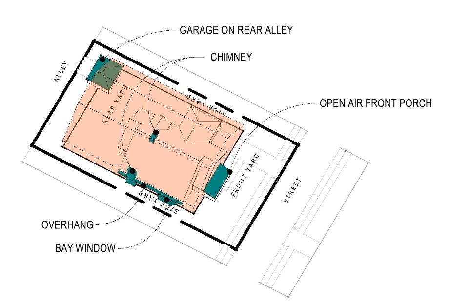
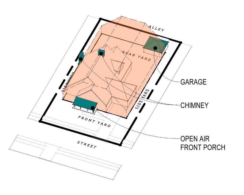
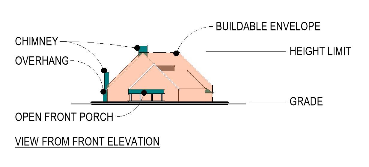
7.06 RULES OF MEASUREMENT
a) Front lot line is the right-of-way line.
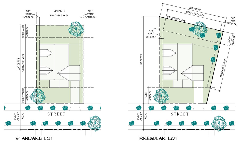
b) Front lot line is the center line of the roadway.
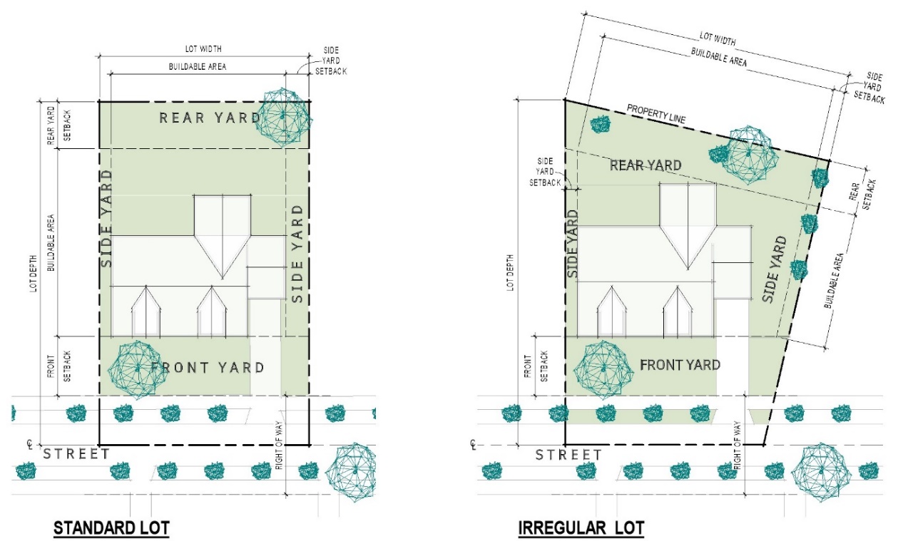
7.07 TYPES OF LOTS
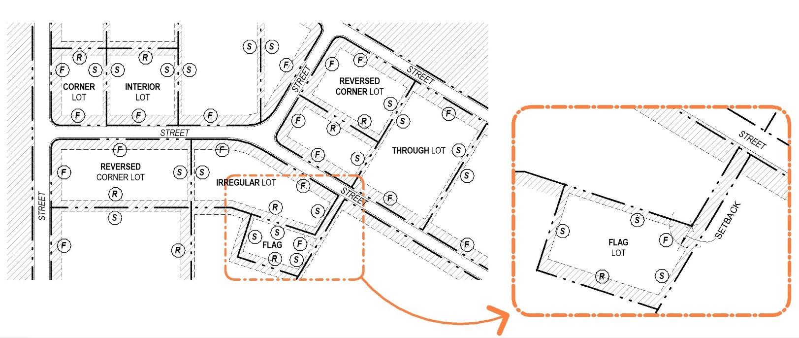
Front, rear, and side setbacks must comply with the requirements of the applicable zoning district. The purpose of the above graphic is to illustrate which lot lines serve as front, rear, and side lot lines for each type of lot.
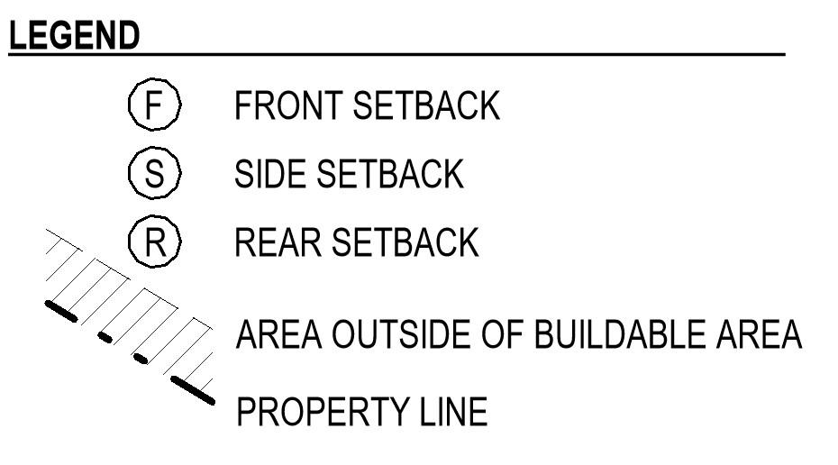
For a flag lot, the front yard shall be determined by identifying the midpoint of the terminus of the panhandle (or the terminus of an easement outside of the panhandle) and drawing a semi-circle with a radius that is equal to the minimum front setback for the applicable Zoning District.
ARTICLE 8 – USE TABLES
8.01 IDENTIFIED USES
a) Each Zoning District includes a list of Permitted, Conditional, and Accessory Uses. Listed Uses are to be defined by their customary name or identification, except as specifically defined or limited by this Resolution. If a Use is not listed as a Permitted, Conditional, or Accessory Use in a Zoning District, it shall be considered prohibited in said Zoning District.
b) Permitted Uses. A Permitted Use is allowed by a matter of right when designated as such in a Zoning District, provided said Use complies with all applicable Setback and development standards and is issued a Zoning Permit from the Zoning Inspector, or their designee. Such Uses are designated with a “P” in each Zoning District.
c) Conditional Uses. A Conditional Use may be allowed when designated as such in a Zoning District, provided it complies with the criteria in Section 3.07 and a Conditional Use Zoning Permit is issued by the Zoning Commission in accordance with Section 3.07. Such Uses are designated as “C” in each Zoning District.
d) Accessory Uses. An Accessory Use may be allowed when designated as such in a Zoning District, provided it is subordinate to the primary Use, complies with the requirements of Section 17.02 and is issued an Accessory Use Zoning Permit from the Zoning Inspector, or their designee. Such Uses are designated with an “A” in each Zoning District. Such Uses are designated with an “A” in each Zoning District.
e) Development Standards. Each Zoning District has a set of development standards to which each Use and Structure must comply. These standards include: height; Lot Width; Lot Size; and Front, Side, and Rear Setbacks. In addition to the development standards in each Zoning District, all applicable Uses must comply with any applicable “General Development Standards” listed in Article 17.
8.02 USE TABLE – RESIDENTIAL AND MIXED USE
Use | Farm Residential (FR) | Rural Residential (RR) | Clustered Conservation Overlay (CC) | Mixed-Use Overlay (MU) |
|---|---|---|---|---|
Dwelling, One Unit | P | P | P | P |
Dwelling, Duplex | P | P | ||
Dwelling, Triplex | P | P | ||
Dwelling, Multi-Unit | P | |||
Dwelling, Studio, One-, Two-, or Three-Bedroom Units | P | |||
Accessory Dwelling Unit, Accessory Suite (Subject to Section 17.01) | C | C | P | P |
Accessory Structures (Subject to Section 17.02) | P | P | P | P |
Agritourism (Subject to Section 17.03) | C | |||
Airports/Private Landing Strips | C | |||
Animal Service Facilities | P | |||
Assisted Living Facilities | P | P | P | P |
Bank, without Banking Window | P | |||
Bed and Breakfast Facilities | C | C | ||
Beverage Sales, Microbrewery | P | |||
Beverage Sales, Alcoholic | P | |||
Body Art Establishment | P | |||
Business, Retail Small with Drive-Thru (with Pick-Up Window) | C | |||
Business, Retail Small with Pick Up Window (No Drive-Thru) | C | |||
Business, Retail Small (No Drive-Thru or Pick Up Window) | P | |||
Business, Retail Medium with Pick-Up Window (No Drive-Thru) | P | |||
Business, Retail Medium No Drive-Thru or Pick Up Window | P | |||
Cemetery (Subject to Section 17.06) | C | C | P | P |
Commercial Recreation Facilities, Small | P | |||
Commercial Recreation Facilities, Large | P | |||
Commercial Recreation Facilities, Outdoor | C | C | P | |
Community Services | C | C | P | |
Contractor Office | P | |||
Day Care Centers | P | P | ||
Early Childhood Learning Center | P | P | ||
Elderly/Retirement Housing | P | P | P | |
Emergency and Protective Services Shelter (Subject to Section 17.13) | P | |||
Equipment Repair, Small | P | |||
Farm Market | C | P | ||
Flea Market | P | |||
Flex Office – Retail | A | A | ||
Food Cart/Tent (Subject to Section 17.21) | P | |||
Food Truck (Subject to Section 17.10) | P | |||
Funeral Service Facilities | P | |||
Governmental Services | P | P | P | P |
Health Care Facilities | C | C | P | P |
Home Day Care Family, Large | C | C | P | P |
Home Day Care Family, Small | P | P | P | P |
Home Occupations, Major (Subject to Section 17.11) | C | C | P | P |
Home Occupations, Minor (Subject to Section 17.11) | P | P | P | P |
Hotels/Motels | P | |||
Hotels, Boutiques | P | |||
Kennel, Agricultural | P | P | P | P |
Kennel, Boarding | C | |||
Life Care Retirement Center | P | P | P | |
Machine Shop | ||||
Maker Space, Small | P | P | P | |
Municipal Services | P | P | ||
Nursing Home | P | P | P | P |
Offices, Administrative, Business Medical or Professional, Small | P | |||
Off-Street Parking and Garages as a Principal Use (Subject to Article 16) | P | |||
Outdoor Seasonal Businesses | P | |||
Outdoor Service Facilities | P | |||
Park, Neighborhood | P | P | P | P |
Park, Community or Regional | P | P | P | P |
Permanent Supportive Housing (Subject to Section 17.13) | P | |||
Personal Services | C | C | P | P |
Pick-Up Window | P | |||
Places of Assembly, Large | C | C | P | |
Places of Assembly, Small | P | P | P | |
Portable Home Storage Units (Subject to Section 17.15) | P | C | C | P |
Private Clubs or Lodges | C | C | ||
Private Swimming Pools (Subject to Section 17.16) | P | P | P | |
Public Protection Facility | C | C | P | P |
Residential Facility, Large (Subject to Section 17.13) | P | |||
Residential Facility, Small | P | P | P | P |
Residential Offices, Administrative, Business Medical or Professional | P | |||
Residential Treatment Center (Subject to Section 17.13) | P | |||
Restaurant with Pick Up Window (No Drive-Thru) | P | |||
Restaurants with No Drive-Thru or Pick Up Window | P | |||
School, Primary, Intermediate, or Middle | C | P | P | P |
School, High or Technical | C | P | P | P |
School, Post-Secondary | C | C | P | P |
Shooting Range, Indoor | C | |||
Shooting Range, Outdoor | C | |||
Short-Term Rentals (Subject to Section 17.18) | C | C | C | C |
Solar Energy Systems | Subject to Section 17.19 | |||
Telecommunication Tower, Attached (Subject to Section 17.20) | C | C | P | P |
Telecommunication Tower, Free Standing (Subject to Section 17.20) | C | C | P | P |
Temporary Structures (Subject to Section 17.21) | C | C | P | P |
Temporary Tents (Subject to Section 17.21) | C | C | P | P |
Transitional Living Center (Subject to Section 17.13) | P | |||
Truck and Travel Service Centers | ||||
Vehicle Charging Stations | P | |||
Wind Energy Conversion Systems (Subject to Section 17.23) | C | C | ||
8.03 USE TABLE – COMMERCIAL AND INDUSTRIAL
Use | Community Business (CB) | Light Industrial Overlay (LIO) |
|---|---|---|
Accessory Structures (Subject to Section 17.02) | P | |
Adult Entertainment Uses (Article 14) | C | P |
Advanced Manufacturing | P | |
Animal Service Facilities | P | |
Assisted Living Facilities | P | |
Automobile Oriented Uses | P | |
Automobile Oil Change Facility | P | |
Automobile Repair | P | |
Bank, with Banking Window | P | |
Bank, without Banking Window | P | |
Beverage Sales, Microbrewery | P | |
Beverage Sales, Alcoholic | P | |
Bio-Technology Facility | P | |
Body Art Establishment | P | P |
Business, Retail Small with Drive-Thru (with Pick-Up Window) | P | |
Business, Retail Small with Pick Up Window (No Drive-Thru) | P | |
Business, Retail Small (No Drive-Thru or Pick Up Window) | P | |
Business, Retail Medium with Drive-Thru | P | |
Business, Retail Medium with Pick-Up Window (No Drive-Thru) | P | P |
Business, Retail Medium No Drive-Thru or Pick Up Window | P | P |
Business, Retail Large (May include Drive-Thrus and Pick Up Windows) | P | |
Business, Wholesale | P | |
Cemetery (Subject to Section 17.06) | P | P |
Commercial Recreation Facilities, Small | P | |
Commercial Recreation Facilities, Large | P | |
Commercial Recreation Facilities, Outdoor | P | |
Community Services | P | |
Contractor Office | P | P |
Day Care Centers | P | |
Early Childhood Learning Center | P | |
Elderly/Retirement Housing | P | |
Emergency and Protective Services Shelter (Subject to Section 17.13) | C | |
Equipment Repair, Large | P | |
Equipment Repair, Small | P | P |
Farm Market | P | |
Flea Market | P | |
Flex Office – Laboratory/Research/ Development | P | |
Flex Office – Retail | P | |
Flex Office – Warehouse | P | |
Food Cart/Tent (Subject to Section 17.21) | P | |
Food Truck (Subject to Section 17.10) | P | P |
Funeral Service Facilities | P | |
Governmental Services | P | P |
Health Care Facilities | P | P |
Hotels/Motels | P | |
Hotels, Boutiques | P | |
Junk Yards and Scrap Metal Processing Facilities | P | |
Kennel, Agricultural | P | P |
Kennel, Boarding | P | |
Landscape and Hardscape Business | P | P |
Life Care Retirement Center | P | |
Logistics | P | |
Lumberyard | P | |
Machine Shop | P | |
Maker Space, Small | P | P |
Maker Space, Large | P | P |
Manufacturing | P | |
Municipal Services | P | P |
Nursing Home | P | |
Offices, Administrative, Business, Medical or Professional, Large | P | P |
Offices, Administrative, Business, Medical or Professional, Small | P | P |
Off-Street Parking and Garages as a Principal Use (Subject to Article 16) | P | P |
Outdoor Seasonal Businesses | P | |
Outdoor Service Facilities | P | |
Park, Neighborhood | P | P |
Park, Community or Regional | P | P |
Personal Services | P | |
Pick-Up Window | P | P |
Places of Assembly, Large | P | |
Places of Assembly, Small | P | |
Plants, Asphalt/Concrete | P | |
Portable Home Storage Units (Subject to Section 17.15) | P | |
Public Protection Facility | C | P |
Residential Facility, Large (Subject to Section 17.13) | C | |
Residential Facility, Small | P | |
Residential Treatment Center (Subject to Section 17.13) | C | |
Restaurant (with Drive-Thru) | C | |
Restaurant with Pick Up Window (No Drive-Thru) | P | |
Restaurants with No Drive-Thru or Pick Up Window | P | |
School, Primary, Intermediate, or Middle | P | |
School, High or Technical | P | |
School, Post-Secondary | P | |
Solar Energy Systems | Subject to Section 17.19 | |
Telecommunication Tower, Attached (Subject to Section 17.20) | P | P |
Telecommunication Tower, Free Standing (Subject to Section 17.20) | P | P |
Temporary Structures (Subject to Section 17.21) | P | P |
Temporary Tents (Subject to Section 17.21) | P | P |
Transitional Living Center (Subject to Section 17.13) | C | P |
Truck and Travel Service Centers | P | |
Vehicle Charging Stations | P | |
Vehicular Sales, New and Used Cars | P | |
Vehicular Sales, Motorcycles | P | |
Vehicular Sales, Recreational Vehicles | P | |
Vehicular Sales, Equipment | P | |
ARTICLE 9 – RESIDENTIAL & COMMERCIAL DISTRICTS
9.01 FARM RESIDENTIAL (FR)
a) Purpose.
The Farm Residence District (FR) is to provide for the use of appropriate land for continued agricultural purposes and to permit construction of low-density single-family residences and for other non-urban types of residential and agricultural activities so that the rural character of these areas may be maintained and preserved.
b) Target Areas.
c) Permitted, Conditional, and Accessory Uses.
See, Section 8.02 – Use Table – Residential and Mixed Use.
d) Lot Area, Setback, Height, and Lot Coverage Requirements.
Development Standards | Farm Residential |
|---|---|
Minimum Lot Size (Acres) | 5 |
Maximum Density (utilize gross acres) | 1 dwelling unit per 5 acres |
Minimum Frontage (Feet) | 300 |
Minimum Front Setback (Feet) | 75 |
Maximum Front Setback (Feet) | N/A |
Minimum Side Setback (Feet) | 25 |
Minimum Rear Setback (Feet) | 50 |
Maximum Building Height (Feet) | 35 |
Maximum Lot Coverage | N/A |
Minimum Gross Floor Area for Primary Residential Use (Square Feet) | 1,400 (fewer than 2 stories) 1,800 (2 stories or more) |
Maximum Number of Dwellings per Lot | 1 |
Projection into required setback Cornices, canopies, eaves (roof overhang), fireplaces-chimneys, bay window, porch, stoop, or other similar architectural features may project into a required setback up to two (2) feet. | |
Common Access Drive (CAD): Any parcel of land which at the building setback line is separate or removed from the public road by more than one other parcel of land shall be accessed only by a CAD. A CAD may be permitted by following a plat as approved by the Delaware County Regional Planning Commission. All CADs shall be paved within the right-of-way. For lots having frontage on streets having extreme curvature, the Minimum Lot Frontage requirements shall be measured at the Front Setback Line. Where streets have extreme curvature, no more than three (3) lots with such reduced lot width at the street line shall be permitted. | |
Private Access Drives: All private access drives for individual lots which terminate at a length greater than eight (80) feet from a public street shall not be less than twelve (12) feet in width and shall be constructed over an aggregate base of ten (10) inches or other depth necessary to support the weight of service and emergency vehicles. Private access driveways for individual lots with a travel length over 400 feet shall be designed to provide widened passing areas for a total width of 15 feet and 30 feet in length at intervals not more than 300 feet in distance from each other. Construction requirements shall be as listed above. All culverts, bridges, and similar drainage facilities constructed as integral components of access drives shall be certified by a professional engineer in writing that good engineering practices have been utilized in their design and construction and that such structures meet current standards as necessary to protect the public safety and general welfare. Gates at access drive entrances shall provide manual or automatic release mechanisms for emergency vehicle access. Electronically or manually locking gates which cannot meet the above requirements are prohibited. | |
e) Example Lot Layout and Rendering.
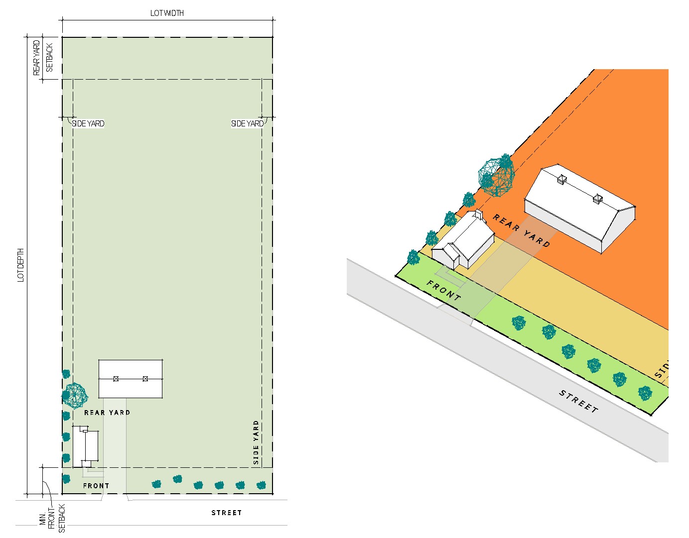
f) General Development Regulations.
Applicable | Section Reference | Notes | |
|---|---|---|---|
Accessory Structures | Y | Section 17.02 | Detached Accessory Structures may not encroach a side or rear setback. Accessory structures shall also comply with all other requirements in Section 9.01(d). |
Fences | Y | Section 17.09 | Fences and walls may be placed in a required minimum setback provided they comply with Section 9.01(d). |
Landscaping/Buffering | Y | Section 17.12 | Plant material and berms may be placed in any required minimum setback provided they do not constitute a nuisance as provided in the Township’s Resolutions. |
Parking | Y | Article 16 | Parking must be provided under Article 16. Parking is prohibited on lawns or other unpaved areas. |
Signs* | Y | Article 15 | Signs, provided they comply with Section 9.01(d), may be located within a front setback. *Signs are conditional uses in the |
9.02 RURAL RESIDENTIAL (RR)
a) Purpose.
The Rural Residential District (RR) is to provide for residential lots of a relatively spacious nature while maintaining the rural character of the Township.
b) Target Areas.
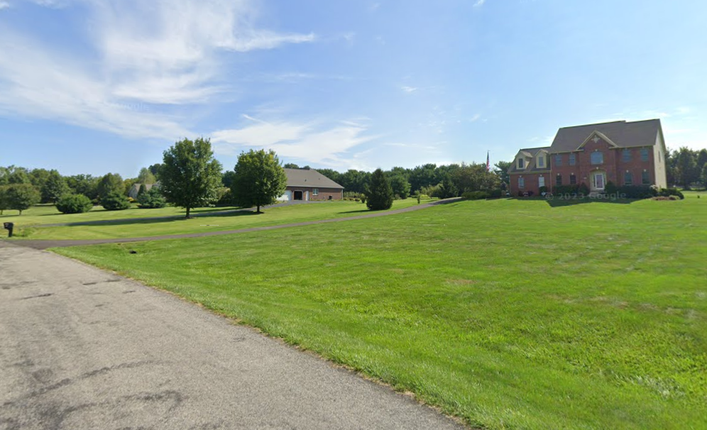
c) Permitted, Conditional, and Accessory Uses.
See, Section 8.02 – Use Table – Residential and Mixed Use.
Lot Area, Setback, Height, and Lot Coverage Requirements.
Development Standards | Rural Residential |
|---|
Minimum Lot Size (Acres) | 3 |
|---|---|
Maximum Density (utilize gross acres) | 1 dwelling unit per 3 acres |
Minimum Frontage (Feet) | 250 |
Minimum Front Setback (Feet) | 75 |
Maximum Front Setback (Feet) | N/A |
Minimum Side Setback (Feet) | 25 |
Minimum Rear Setback (Feet) | 50 |
Maximum Building Height (Feet) | 35 |
Maximum Lot Coverage | 10% |
Minimum Gross Floor Area for Primary Residential Use (Square Feet) | 1,400 (fewer than 2 stories) 1,800 (2 or more stories) |
Maximum Number of Dwellings per Lot | 1 |
Projection into required setback Cornices, canopies, eaves (roof overhang), fireplaces-chimneys, bay window, porch, stoop, or other similar architectural features may project into a required setback up to two (2) feet. | |
Common Access Drive (CAD): Any parcel of land which at the building setback line is separate or removed from the public road by more than one other parcel of land shall be accessed only by a CAD. A CAD may be permitted by following a plat as approved by the Delaware County Regional Planning Commission. All CADs shall be paved within the right-of-way. For lots having frontage on streets having extreme curvature, the Minimum Lot Frontage requirements shall be measured at the Front Setback Line. Where streets have extreme curvature, no more than three (3) lots with such reduced lot width at the street line shall be permitted. | |
Private Access Drives: All private access drives for individual lots which terminate at a length greater than eight (80) feet from a public street shall not be less than twelve (12) feet in width and shall be constructed over an aggregate base of ten (10) inches or other depth necessary to support the weight of service and emergency vehicles. Private access driveways for individual lots with a travel length over 400 feet shall be designed to provide widened passing areas for a total width of 15 feet and 30 feet in length at intervals not more than 300 feet in distance from each other. Construction requirements shall be as listed above. All culverts, bridges, and similar drainage facilities constructed as integral components of access drives shall be certified by a professional engineer in writing that good engineering practices have been utilized in their design and construction and that such structures meet current standards as necessary to protect the public safety and general welfare. Gates at access drive entrances shall provide manual or automatic release mechanisms for emergency vehicle access. Electronically or manually locking gates which cannot meet the above requirements are prohibited. | |
d) Example Lot Layout and Rendering.
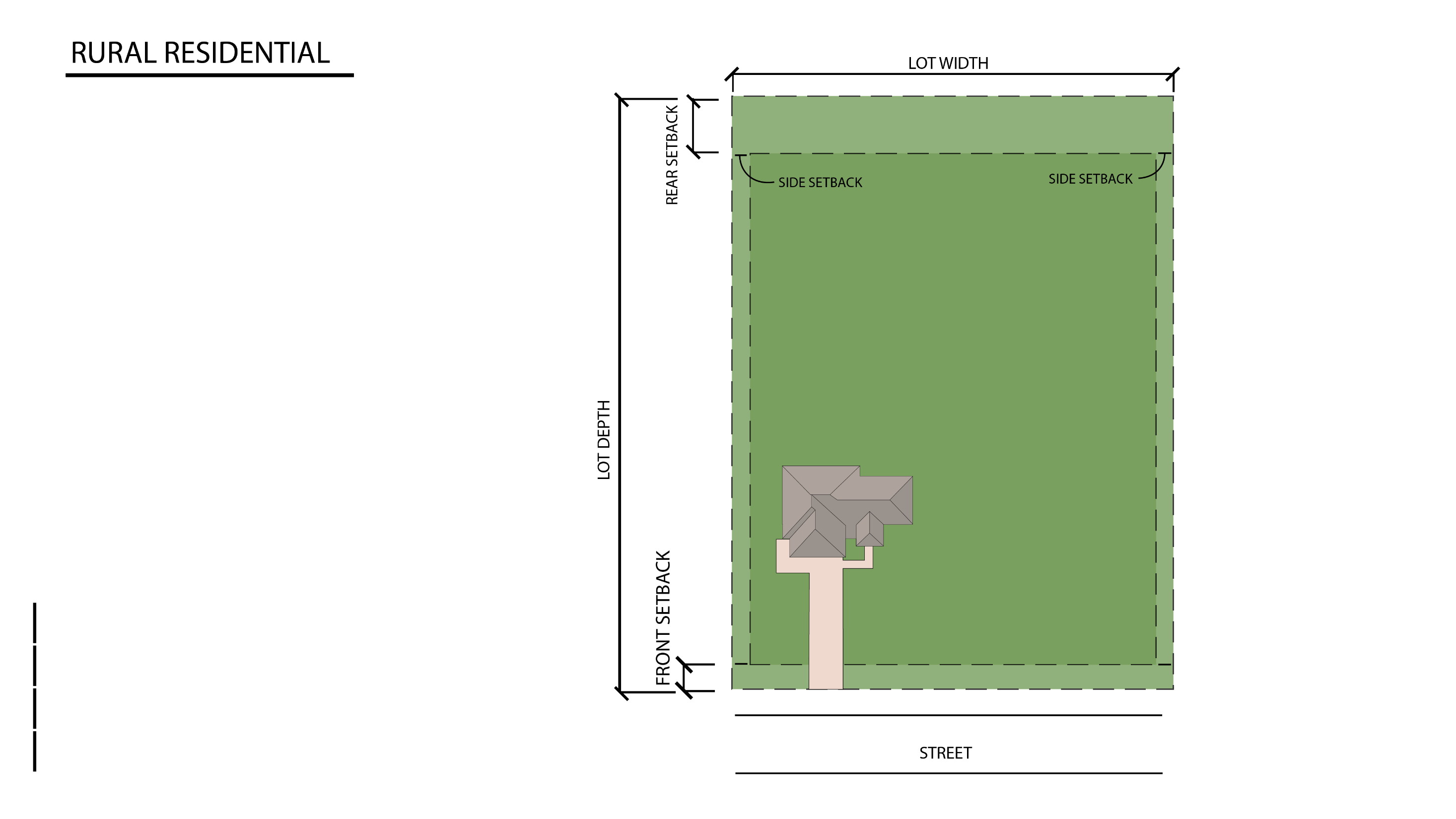
e) General Development Regulations.
Applicable | Section Reference | Notes | |
|---|---|---|---|
Accessory Structures | Y | Section 17.02 | Detached Accessory Structures may not encroach a side or rear setback. Accessory structures shall also comply with all other requirements in Section 9.02(d). |
Fences | Y | Section 17.09 | Fences and walls may be placed in a required minimum setback provided they comply with Section 9.02(d) |
Landscaping/Buffering | Y | Section 17.12 | Plant material and berms may be placed in any required minimum setback provided they do not constitute a nuisance as provided in the Township’s Resolutions. |
Parking | Y | Article 16 | Parking must be provided under Article 16. Parking is prohibited on lawns or other unpaved areas. |
Signs* | Y | Article 15 | Signs, provided they comply with Section 9.02(d), may be located within a front setback. *Signs are conditional uses in the |
9.03 COMMUNITY BUSINESS (CB)
a) Purpose.
The Community Business District (CB) is to provide the Township with areas for business and service establishments which are pleasant, safe, and convenient for their neighborhoods.
b) Target Areas.
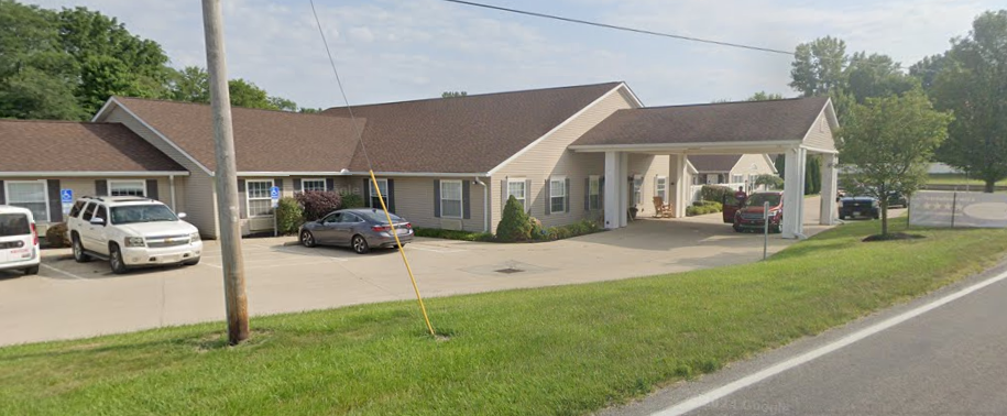
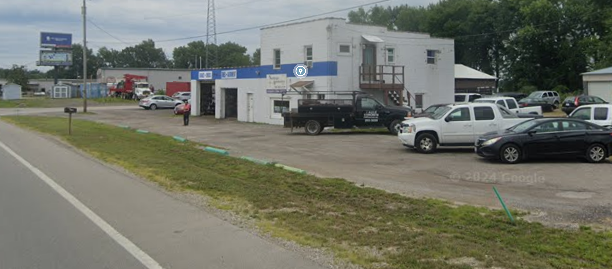
c) Permitted, Conditional, and Accessory Uses.
See, Section 8.03 – Use Table – Commercial and Industrial.
d) Lot Area, Setback, Height, and Lot Coverage Requirements.
Development Standards | Community Business |
|---|
Minimum Lot Size (Square Feet) | 10,000 |
|---|---|
Minimum Frontage (Feet) | 100 |
Minimum Front Setback (Feet) | 50 |
Maximum Front Setback (Feet) | N/A |
Minimum Side Setback (Feet) | 20 |
Minimum Rear Setback (Feet) | 35 |
Maximum Building Height (Feet) | 35 |
Maximum Lot Coverage (Percent) | 35 |
Projection into required setback Cornices, canopies, eaves (roof overhang), fireplaces-chimneys, bay windows, porch, stoop, or other similar architectural features may project into a required setback up to two (2) feet. | |
e) Example Lot Layout and Rendering.
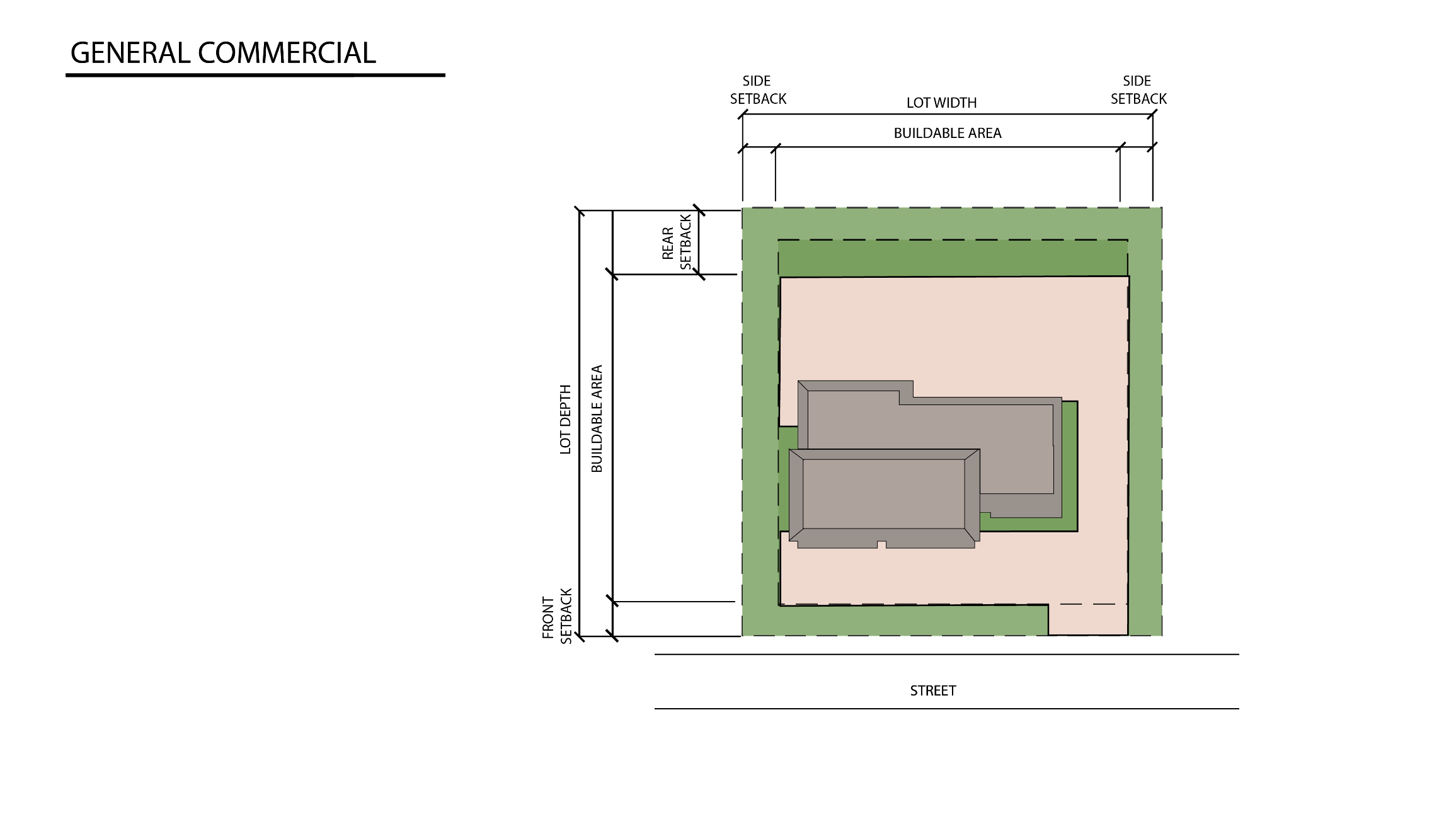
f) General Development Regulations.
Applicable | Section Reference | Notes | |
|---|---|---|---|
Accessory Structures | Y | Section 17.02 | Detached Accessory Structures may not encroach a side or rear setback. Accessory structures shall also comply with all other requirements in Section 9.03(d). |
Fences | Y | Section 17.09 | Fences and walls may be placed in a required minimum setback provided they comply with Section 9.03(d). |
Landscaping/Buffering | Y | Section 17.12 | Plant material and berms may be placed in any required minimum setback provided they do not constitute a nuisance as provided in the Township’s Resolutions. |
Parking | Y | Article 16 | Parking must be provided under Article 16. Parking is prohibited on lawns or other unpaved areas. |
Signs | Y | Article 15 | Signs, provided they comply with Section 9.03(d), may be located within a front setback. |
ARTICLE 10 – CLUSTERED CONSERVATION OVERLAY (CC)
10.01 PURPOSE
The Clustered Conservation Residential Overlay (CC) is an overlay district created under Section 519.021(C) of the ORC to promote the general public welfare, encourage the efficient use of land and resources, provide public and utility services with greater efficiency, and innovate planning and development. The CC can achieve these goals by allowing the development of clustered residential housing alongside land conservation that:
a) Permanently preserve and integrate open space within residential developments;
b) Offer landowners alternatives to standard tract development of their land;
c) Establish a less sprawling, more efficient use of land, streets, and utilities on tracts where central water and sewer are available;
d) Protect and conserve farmland, historical and cultural features, and minimizes topographical changes and damage to existing landscapes and vegetation;
e) Create usable and accessible open spaces, recreational areas, gathering places, and green corridors for wildlife, walking trails and/or bike paths;
f) Encourage creativity and environmental responsibility in design through a controlled process of review and approval of the Development Plan and related documents;
g) Enable an extensive review of design characteristics to ensure that projects are properly integrated into the surroundings and are compatible with adjacent development; and
h) Encourage unified development projects that exhibit creative planning and design in ways that cannot be achieved through a standard zoning district yet are imaginative in architectural design and are consistent with applicable public plans for the area.
10.02 OVERLAY AREA
The CC is created under Section 519.021 (C) of the ORC and encompasses, includes, and overlays all land shown with a crosshatch on the Zoning Map on the effective date of this resolution.
10.03 EFFECT OF CC OVERLAY
The underlying zoning district shall apply to all property within the CC, unless the Board of Township Trustees under Section 3.12-3.19 approves a Development Plan application submitted by a property owner and/or their agent (the "Applicant"), to subject the provisions of the CC. Such an application shall be made under the provisions of this Article and all other applicable Articles of this Code.
10.04 PERMITTED USES
a) Within the CC, only uses listed in Section 8.02 shall be permitted when developed is in strict compliance with the approved Development Plan and the standards of this Resolution. The precise use or type of use of the tract shall be specified in the plan as submitted and approved. Uses listed as permitted in Section 8.02 are allowed by a matter of right. If a use is not designed as permitted in Section 8.02, it shall be considered prohibited.
b) No change in approved use shall be permitted without obtaining approval of a new/revised Development Plan.
c) Temporary Structures. Temporary structures such as manufactured/mobile offices and temporary buildings may be used incidentally to construction work on the premises or on adjacent public projects during a period while the permanent structure is being constructed. The user of said structure shall obtain a permit for such temporary use, which permit shall be valid for one (1) year and may be renewed by the Zoning Inspector in three (3) month increments. The Zoning Inspector shall not issue more than two extensions for a total combined period of time under all issued permits not exceeding eighteen (18) months. Renewal of the permit shall be at the discretion of the permanent structure or project. The Zoning Inspector shall require provisions for sanitary waste disposal, solid waste disposal, and water supply, as they deem necessary. The fees for such permit and renewals thereof shall be established by the Board of Townships Trustees. Said temporary structure shall be removed not later than ten (10) days after expiration of said permit.
10.05 CC DEVELOPMENT PLAN STANDARDS
a) Minimum gross tract size for a CC Subdivision – Twenty-five (25) acres;
b) Open Space – At least fifty percent (50%) of the gross tract acreage shall be designated as permanent open space, not to be further developed. Open space locations shall be identified on the Development Plan and shall be subject to the approval of the Zoning Commission. Open space shall be owned, administered, and maintained as identified on the Development Plan under Section 10.06. With prior consent through resolution of the Township Board of Trustees, land may be transferred to the Township for public purposes if approved as a part of the Development Plan. Uses of land transferred to the Township for public purposes must be approved as a part of the Development Plan and may include but are not limited to passive and active recreation areas. The decision whether to accept an applicant’s offer to dedicate open space for public use shall be at the discretion of the Township Board of Trustees. Land dedicated to public purposes may count toward the open space requirement if approved on the Development Plan:
1) In calculating open space, the areas of fee simple lots conveyed to homeowners shall not be included;
2) Primary conservation areas, stormwater management detention/retention ponds, and constructed wetlands acting as detention basins may count in their combined aggregate for up to fifty percent (50%) of the required open space;
3) Any area of natural open space that is proposed to be disturbed during construction or otherwise not preserved in its natural state shall be shown on the Development Plan and, if required, shall be restored with vegetation that is compatible with the natural characteristics of the site. The method and timing of any restoration shall be set forth in the Development Plan; and
4) Open space must be clustered to achieve the purpose of creating large open tracts. Consideration must be taken for surrounding developments to ensure that the open space for neighboring developments is located connecting or close to the open space for the new development in the CC.
c) Site Design Process:
1) Delineate primary conservation areas: preserve as natural open space;
2) Delineate secondary conservation areas: preserve selected areas as improved or natural open space;
3) Draw house footprints and lot lines outside the conservation areas based upon the permitted density calculations based on Section 10.06; and
4) Site Design Standards:
i. To reduce visual impact, locate dwellings along the edges rather than in the center of an open field if they will be seen from existing public roads. Avoid new construction on prominent hilltops or ridges;
ii. Front dwellings on internal roads, not on external roads;
iii. Locate all house lots within 400 feet of the permanent open space;
iv. Retain or restore native vegetation adjacent to wetlands and surface waters;
v. Preserve existing hedge and tree lines to an extent practicable;
vi. Preserve scenic views;
vii. Protect wildlife habitat areas of species listed as endangered, threatened, or of special concern by the Ohio Department of Natural Resources;
viii. Preserve historic or archaeological sites (e.g., earthworks, burial grounds, etc.);
ix. Landscape or retain vegetation in common areas with native trees and shrubs;
x. Place shade trees along internal roads at fifty (50) foot intervals on at least one side of the road;
xi. Provide active recreational areas in suitable locations;
xii. Include a viable pedestrian circulation system, meaning a minimum of a five (5) foot wide bike and walking path throughout the development. Provide for connection to surrounding neighborhoods (existing and potential);
xiii. Protect natural drainage swales and creeks. No construction of buildings is allowed inside the 100-year floodplain. In addition, no residential structures are permitted within one hundred (100) feet of the ordinary high-water line of a riparian or wetland area as determined by a professional engineer’ and
xiv. Provide permanent open space.
d) Determining The Number of Dwelling Units Permitted - The permitted density is noted in Table 10.05(a), below.
Table 10.05(a)
CC with Sewer | CC without Sewer | |
|---|---|---|
Maximum Dwelling Units Per Gross Developable Acre | 3 | 1 |
e) Sewage Disposal – A feasibility letter shall be provided by the Delaware County Sanitary Engineer indicating that sewer service is available with the capacity needed;
f) Stormwater – Features shall be designed to manage stormwater retention and prevent erosion, flooding, or standing water within and through the site to maintain, as far as practicable, usual, and normal swales, water courses and drainage areas and prevent any upstream or downstream impacts. No water shall be allowed to be released beyond what was released pre-development. Regional detention ponds and wetlands shall be utilized with soft edges to integrate the stormwater feature into the natural landscape and effectively manage stormwater without the excessive use of multiple ponds;
g) Subdivision Standards – Public streets and all drainage improvements shall conform to the subdivision standards for Delaware;
h) Pavement Standards for Private Drives – All private drives that are not dedicated for public maintenance shall be constructed to a pavement width and cross section that meets the average daily traffic and weights anticipated in the Delaware County Engineer’s Design, Construction and Surveying Standards Manual or shall have a design life of twenty (20) years;
i) Pavement Standards for Parking Lots – Parking lots and private driveways do not have to meet street cross sectional standards, but parking lot drive aisles that connect to the public streets shall be constructed to public street cross sectional and design life standards within fifty (50) feet of the edge of the public paved road;
j) Paths – A minimum of five (5) foot wide walking or ten (10) foot wide bike path is required for conservation subdivisions. Paths shall be constructed as to meander through the development, in line with the rural character and feel of the area and to connect existing and potential residential areas and open spaces. The Township may also require paved or unpaved walkways to connect residential areas and open spaces;
k) Street Trees – Native deciduous, broad leaf street trees with a minimum caliper of two (2) inches at planting shall be planted (or retained) at least every fifty (50) lineal feet along at least one side of the street(s);
l) Bulk and Area requirements see Table 10.05(b), below:
TABLE 10.05(2)
CC with Sewer | CC without Sewer | |
|---|---|---|
Minimum Tract Size (Acres) | 25 | 25 |
Minimum Perimeter Tract Setback | No building shall be constructed within fifty (50) feet of the external boundary of the conservation subdivision, except, however, no building shall be located within 200 feet of the proposed right-of-way for an existing state, county, or township roadway. | |
Minimum Setback from new Local Road ROW (Feet) | 25 | 50 |
Minimum Lot Size (Square Feet) | 7,500 | 1 acre |
Minimum Lot Width (Feet) | 60’ for a maximum of 40% of the total single family lots | 100 |
70’ for a maximum of 50% of the total single family lots | ||
80’ or wider for at least 10% of the total single family lots. 80’ or wider for all common wall attached dwellings. | ||
Minimum Side Yards (Feet) for 60’ Lot | 5’ each side | |
Minimum Side Yards (Feet) for 70’ Lot | Combined 15’, no less than 5’ on one side | |
Minimum Side Yards (Feet) for 80’ Lot | Combined 15’, no less than 5’ on one side | |
Minimum Side Yard (Feet) for 100’ Lot | n/a | 20 |
Maximum Building Height (Feet) | 35* | 35 |
Minimum Driveway Setback from Side Lot Line (Feet)** | 2*** | 2*** |
Minimum Rear Yard (Feet) | 25 | 40 |
Minimum Setback for Accessory Structures (Feet) | 15 | 15 |
*Building Height is measured at the highest point of the roof from the established building pad grade as shown on the approved grading plan for the development.
** A shared driveway is allowed when required by the Driveway Permitting Authority due to sight distance or spacing purposes.
*** Side-load garages shall provide at least twenty-four (24) feet of paved apron, exclusive of the two (2) foot side lot line for single family detached dwellings on fee simple ownership lots.
m) Minimum Dwelling Unit Floor Area – No dwelling shall be constructed in said Zoning District of the Township unless the same shall have at least the minimum square feet of living area, exclusive of basements, porches, breezeways, utility areas, and garages as set forth in the following schedule of dwelling types:
1) One (1) story – 1500 square feet of living area above grade. One and one half (1 ½) or two (2) story – 2000 square feet of living area above grade.
2) All dwellings shall include a garage (attached or unattached) of a minimum of four hundred eighty (480) square feet complete with operating doors; this area is not to be included in the living area of the dwelling;
n) Building Design – The intent of the building design requirements is to create a Rural Design theme that is representative of traditional rural architectural design by focusing on materials and colors that transcends design fads while simultaneously allowing for a unique design approach for individual projects through the review and guidance from the Zoning Commission. Buildings and structures shall be designed to enhance both areas within and surrounding the development, giving due regard to building footprints, building orientation, massing, roof shape, pitch, and exterior materials. The following material and design element requirements have been established to achieve the Rural Design theme:
1) Building Materials and Design Elements: Buildings for all uses shall be designed to be seen from three hundred sixty degrees (360°) and have the same caliber of finish on all elevations. Building additions and accessory structures, whether attached or detached, shall be of similar design, materials, and construction to that of the existing principal structure. Additionally, the following standards shall apply to the specific uses:
2) For all buildings in the CC, the following design requirements apply:
i. Building Materials: All exterior elevations shall be comprised of wood, fiber cement, board and batten, brick, or native or cultured stone, or vinyl. Foundations must be clad with the same natural material utilized on the building to blend with the overall architecture of the structure. If brick or stone are utilized on the building, the same brick or stone must be used for the foundation. Exposed cement block or split face block foundations shall be prohibited. Aluminum shall be prohibited except when used for trim details such as downspouts, soffits, gutters, and shutters and shall be made to visually appear as a natural material. The use of frosted, black, gold, green, silver, opaque or any other reflective or colored glass on a building is prohibited;
Photo Credit: Pikeproperties.com
Photo Credit: Countryliving.com
Photo Credit: Onekindesign.com
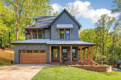
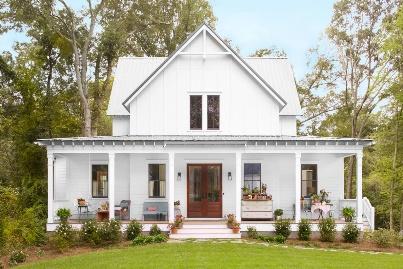
ii. Building Colors: Building colors shall consist of earth tones limited to browns, tans, and grays. Building colors may also consist of white and barn red. Leaf greens and gray sky blues may be utilized as an accent and shall not be the predominant building color; and
iii. Roofing: Flat roofs are prohibited; the roof shall have a minimum of a 4:12 pitch for the main roof. Pitched roofs must be constructed of dimensional shingles, metal, slate, or simulated slate, and are limited to hip, gable, gambrel, or mansard roof types. Other roof types may be approved where appropriate as determined by the Zoning Commission and Township Board of Trustees with Development Plan approval.
o) Landscaping – All yards, front, side, and rear, shall be landscaped to comply with the following regulations. All improved common open space shall be landscaped per the approved Development Plan. A landscape plan for the common open space and streetscape within road right-of-way shall be prepared by a licensed landscape architect showing the caliper, height, numbers, name, and placement of all material, and shall be submitted with and approved as a part of the Development Plan;
1) All proposed landscaping material shall align with the established Rural Design theme utilizing native plantings and grasses such as Karl Foerster Grass;

2) Unless otherwise provided, landscaping material shall be installed to provide a minimum of fifty percent (50%) winter opacity and a seventy percent (70%) summer opacity, between one foot above finished grade level to the top of the required planting, hedge, fence, wall, or earth mound within four years after installation;
Karl Foerster Grass - Photo Credit: Gardenia.net
3) All plants shall meet or exceed American Standards for nursery stock as set forth by the American Association of Nurserymen;
4) All trees and landscaping shall be well maintained. Dead trees, shrubs, and other landscaping material shall be promptly removed and, when required, shall be replaced within six (6) months;
5) Existing tree lines must be preserved, and a two hundred (200) foot woodland buffer must be established from the proposed right-of-way of an existing state, county, or township roadway to any new development:
i) The 200-foot buffer shall consist of a minimum of forty (40) feet in width of native vegetation and trees and shall mimic the natural condition of a forest edge for the purpose of greatly reducing noise pollution and visual impacts of the development from any state, county, or township roadway;
ii) Figure 10.05(k)(1) shows the ideal woodland buffer where grasses, sedges and perennials give way to woody shrubs, before finally transitioning to small flowering trees and young canopy trees;
Figure 10.05(k)(1)
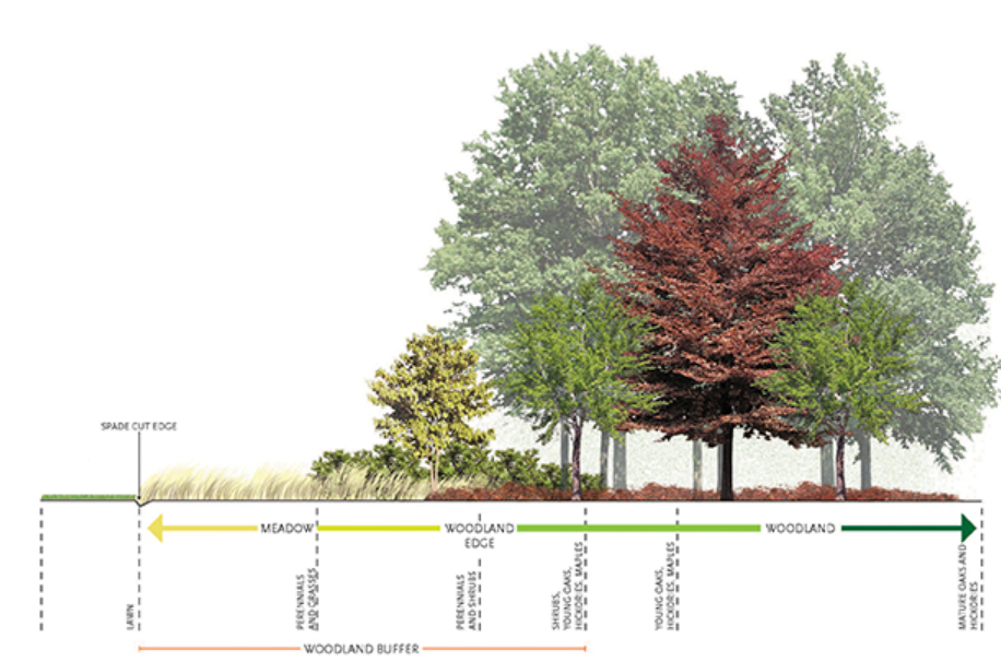
iii) All trees required by these regulations, or other applicable standards, shall be live plants and meet the following minimum tree sizes at the time of planting:
Tree Type Minimum Size at Time of Planting
Deciduous Trees 2-inch caliper
Coniferous/Evergreen 5 feet in height
Shrubs and Hedges 3 feet in height
The following types of undesirable trees and shrubs shall be prohibited as well as any other invasive or undesirable species as listed by the Ohio Department of Natural Resources:
a. Callery Pear (Pryus calleryana – any cultivar)
b. Tree of Heaven/Ailanthus – (Ailanthus altissima)
c. White Mulberry – (Morus alba)
d. Ginko – Female Only – (Ginko biloba)
e. Russian Olive – (Elaeagnus angustifolia)
f. Autumn Olive – (Elaeagnus umbellate); and
g. Japanese Honeysuckle (Lonicera japonica)
Figure 10.05(k)(2)
CC Overlay Buffer | |||
|---|---|---|---|
Min. # of trees per 100 lineal feet of adjoining lot lines must include the following: | |||
Minimum Buffer Width (Feet) | # of Large Trees (a) | # of Small Trees (b) | # of Shrubs (c) |
40 | 4 | 10 | 33 |
Example Buffer – Figure 10.05(k)(3)
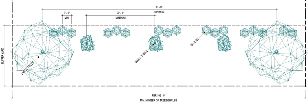
Figure 10.05(k)(4)
6) Additionally, low maintenance ground covers shall be used for earth berms when earth berms are determined, as necessary. Long-term self-maintaining natural plant communities can be used as low maintenance ground covers for earth berms. Berms shall be constructed with a three to one (3:1) slope.
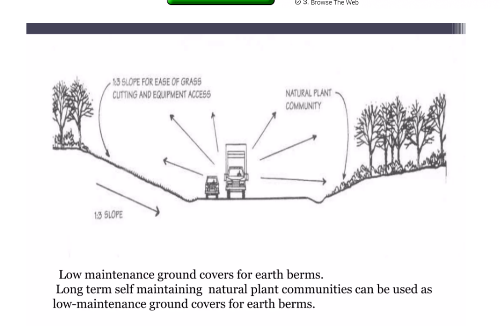
7) Existing landscape material shall be shown on the required plan, and any material in satisfactory condition may be used to satisfy these requirements in whole or in part when such material meets the requirements and achieves the objectives of these Design Standards;
8) An entryway feature may also be used, as approved in the Development Plan, as a portion of the required buffer. The entryway feature must be in line with rural design characteristics and should be predominantly made of natural materials, such as wood, stone, or brick;.
Photo Credit: Was-design.com
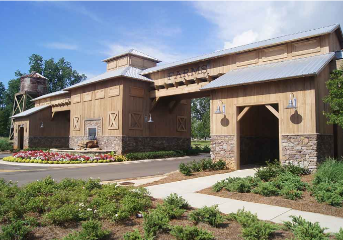
9) Landscaping at Driveway and Street Intersections: To ensure that landscape materials do not constitute a driving hazard, a sight triangle shall be observed at all street intersections or intersections of driveways with streets. Within this sight triangle, neither landscape material nor parked vehicles, except for required grass or ground cover, shall be permitted. Within this sight triangle, trees shall be permitted as long as, except during the early growth stages, only the tree trunk is visible between the ground and eight (8) feet above the ground or otherwise does not present a traffic hazard. The sight triangle is defined in the following sections:
10) Driveway Intersection Triangle: At intersections of driveways with streets, the sight triangle shall be established by locating the intersection of the street curb or edge with the driveway edge, and by measuring from this point and ten (10) feet along the driveway to a point and a distance of twenty (20) feet along the street curb to a point connecting these points; and
11) Street Intersection Sight Triangle: At the street intersections, the sight triangle shall be formed by measuring at least fifty (50) feet along curb lines or edge of pavement and connecting these points.
p) Parking – Off-street parking shall be provided. Construction traffic may park in the street, but only on one side to allow for safe access by emergency equipment. Off-street parking shall comply with the following regulations in Figure 10.05(p);
FIGURE 10.05(p)
Use | Minimum Number of Required Off-Street Parking Spaces |
|---|---|
Common Wall Dwelling Units | 2 spaces per dwelling unit |
Single Family Units | 2 spaces per dwelling unit |
Sports Facilities / Fields | 50 spaces per field |
Neighborhood Parks | 20 spaces |
q) Signs – All signs shall comply with these following regulations, or as approved per the Development Plan:
1) Signs shall be designed as to adhere to the Rural Design theme utilizing natural materials such as stone, wood, or brick for eighty percent (80%) of the sign. Sign colors and fonts should also align with the rural character of the area, utilizing greens, browns, tans, whites, muted blue, or barn red. Signs colors and materials shall match that of the primary building.
2) Temporary Signs: The following Temporary Sign regulations apply to all uses within this Overlay District:
i) Temporary Signs shall be prohibited within the right-of-way.
ii) Two (2) Small Temporary Signs shall be permitted per parcel per street frontage without a permit. Each Small Temporary Sign shall be seven (7) square feet in area or less and less than three (3) feet in height;
iii) One (1) Large Temporary Sign shall also be permitted per parcel provided a Sign permit is issued under the following regulations. Large Temporary Signs shall not:
A) Exceed eight (8) feet in height;
B) Exceed thirty-two (32) square feet in area (per Sign face); and
C) On parcels of five (5) acres or less, such signs shall be displayed for no more than thirty (30) consecutive days and no more than three (3) times per calendar year. A new permit must be obtained for each thirty (30) day or less period. After said permits have been exhausted, the Zoning Inspector may grant one (1) extension for up to ninety (90) days per Sign. No other extensions may be administratively approved and must be approved by the Township Board of Trustees. On parcels that are greater than five (5) acres, such signs may be displayed for up to 180 days. Upon the expiration of this permit, the Zoning Inspector may grant one (1) extension up to an additional 180 days. No other extensions may be administratively approved and must be approved by the Township Board of Trustees. In no case, shall such signs be erected for more than 365 days.
iv) The sign permit number for Large Temporary Signs must be printed on the sign in a visible location; and
v) The majority of the temporary sign must be constructed with wood.
3) Window Signs: All window signs shall comply with the following requirements in Figure 10.05(q)(3):
CC | |
|---|---|
Maximum Number of Signs Permitted Per Lot | 1 |
Maximum Square Footage | 10% of window area |
Maximum Height (Feet) | 15 |
Figure 10.05(q)(3)
4) Residential Subdivision Identification Sign:
i) Such identification shall be limited to wall or ground mounted signs or graphics only, for example, with placement on a brick wall, entrance columns on each side of a street or on a similar architectural or landscaping entrance feature that may be used. The reverse sides of identification features shall be finished to match the fronts. Pole type signage is hereby prohibited. Sign copy shall be limited to the name and logo of the subdivision. Manual changeable copy signs are to be mounted on the rear of an entrance feature. Maximum area for residential manual changeable copy signs is four (4) square feet;
ii) Such identification signs shall be made of at least eighty percent (80%) natural materials including wood, brick, or stone;
iii) Such identification features may not be located in the public right- of-way;
iv) The maximum area for such identification is twenty (20) square feet at any one entry location. A maximum of one permanent residential subdivision identification sign is permitted on each side of the street at each entry location to a development;
v) Any Residential Subdivision Identification Sign shall not be placed closer than ten (10) feet from the right-of-way; and
vi) The maximum height for each sign is six (6) feet above grade.
r) Utilities – All utilities in the CC Subdivision shall be buried underground;
s) Supplemental Conditions and Safeguards – If the Zoning Commission determines that additional measures are needed to buffer existing land uses, they may require such as part of the Development Plan approval; and
t) Divergences – The Township Board of Trustees, as a part of a Development Plan approval process outlined in Section 3.18, may grant divergences from any standard or requirement in this Article with the exception of the density of dwelling units per acre, permitted uses, and the percentage of required open space. An applicant requesting a divergence shall specifically and separately list each requested divergence and the justification therefore on the Development Plan submittals with a request that the proposed divergence be approved “per plan.”
10.06 OWNERSHIP AND MAINTENANCE OF COMMON OPEN SPACE
a) Different ownership and management options may apply to the permanently protected common open space created through the development process. The common open space shall remain in perpetuity and may be owned as identified in this section below. A public land dedication, not exceeding ten percent (10%) of the total parcel size, may be required by the Township to facilitate trail or pathway connections. A narrative describing ownership, use and maintenance responsibilities shall be submitted for all common and public improvements, utilities, and open spaces. Common open space within the development shall be owned, administered, and maintained by any of the following methods, either individually or in combination, and subject to approval by the Township. Funding generated through a New Community Authority (NCA) may be used to manage the required open space.
1) Offer of Dedication. The Township shall have the right of first refusal for common open space in the event said land is to be conveyed to a public agency. Dedication shall take the form of a fee simple ownership. The Township may but is not required to accept common open space provided:
i) Such land is accessible to all the residents of the Township;
ii) There is no cost of acquisition other than incidental costs related to the transfer of ownership;
iii) The Township agrees to maintain such lands; and
iv) Where the Township accepts dedication of common open space that contains improvements, the Township may require the posting of financial security to ensure structural integrity of improvements for a term not to exceed eighteen (18) months.
2) Homeowners Association. The common open space and associated facilities may be held in common ownership by a homeowners association. The association shall be formed and operated under the following regulations:
i) The developer shall provide a description of the association, including its bylaws and methods for maintaining the common open space.
ii) The association shall be organized by the developer and shall be operated by the developer, before the sale of any lots within the development.
iii) Membership in the association is mandatory for all purchasers of homes therein and their successors. The conditions and timing of transferring control of the association from developer to homeowners shall be identified.
iv) The association shall be responsible for payment of insurance and taxes on the common open space. The association may establish rules to ensure proper maintenance of common open space, including monetary liens on the homes and home sites of its members who fail to pay their association dues in a timely manner. Such liens may impose a penalty of interest charges.
v) The members of the association shall share equitably the costs of maintaining and developing, where appropriate, such common open space. Shares shall be defined within the association bylaws.
vi) In the event of transfer, within the methods herein permitted, of common open space by the homeowners’ association, or the assumption of maintenance of common open space by the Township, notice of such pending action shall be given by the homeowners’ association to all property owners within the development.
vii) The homeowners’ association shall provide adequate staff to administer common facilities and property and continually maintain the common open space.
viii) The homeowners’ association may lease common open space to any qualified person or corporation, for operation and maintenance of common open space, but such lease agreement shall provide: That the residents of the development shall at all times have access to the common open space contained therein (except croplands during the growing season);
ix) That the common open space shall be maintained for purposes set forth in the approved Development Plan; and
A) That the operation of common open space may be for the benefit of the residents only or may be open to all residents of the Township, at the election of the developer and/or homeowners association. In cases where public trails or paths are provided as linkage between developments or as a continuous link of common open space within the Township, all residents of the Township shall have access to such identified paths/walkways.
B) The lease shall be subject to the approval of the homeowners’ association board and any transfer or assignment of the lease shall be further subject to the approval of the board. Lease agreements shall be recorded with the Delaware County Recorder’s office and notification shall be provided to the Township Board of Trustees within thirty (30) days of action by the board.
b) Condominium Agreements. The common open space and associated facilities may be controlled through using condominium agreements, approved by the Township. Such agreements shall be in conformance with all applicable laws and regulations. All common open space shall be held as a common element.
c) Dedication of Easements. The Township may, but shall not be required to accept easements for public use of any portion or portions of common open space, title of which is to remain in ownership by condominium or homeowners’ associations, provided:
1) Such land is accessible to Township residents;
2) There is no cost of acquisition other than incidental transfer of ownership costs; and
3) A satisfactory maintenance agreement is reached between the developer, association, and the Township.
d) Transfer of Easements to a Private Conservation Organization. With the permission of the Township, an owner may transfer easements to a private, nonprofit organization, among whose purposes it is to conserve open space and/or natural resources; provided that:
1) The organization is acceptable to the Township, and is a bona fide conservation organization with perpetual existence;
2) The conveyance contains whatever provisions are agreed to between the Township Board of Trustees, the owner, and the organization.
e) With the approval of the Township, common open space may be owned by a third party if protected by either:
1) An open space easement which permanently and irrevocably transfers the development rights for the common open space to a homeowners or condominium association, the Township, or a private conservation organization; or
2) An unmodifiable deed restrictions that permanently restrict the use of the common open space to those uses identified in the approved Development Plan. Common open space to be transferred to a third party other than a homeowners’ association, condominium association or the Township shall also be located in a reserve with an open space notation on a recorded final plat.
f) Maintenance of Common Open Space
1) The ultimate owner of the open space shall be responsible for raising all monies required for operations, maintenance, or physical improvements to the open space through annual dues, special assessments, etc. The owner shall be authorized under the homeowners’ association bylaws to place liens on the property of residents who fall delinquent in payment of dues or assessments.
2) In the event that the organization established to own and maintain common open space shall at any time after establishment of the planned development fail to maintain the common open space in reasonable order and condition under the Development Plan, the Township Board of Trustees may serve written notice upon such organization or upon the residents of the planned development setting forth the manner in which the organization has failed to maintain the common open space in reasonable condition. The notice shall include a demand that such deficiencies of maintenance be cured within thirty (30) days thereof and shall state the date and place of a hearing thereon which shall be held within fourteen (14) days of the notice. At such hearing, the Township Board of Trustees may modify the terms of the original notice, add to the deficiencies, and may give an extension of time within which they shall be cured.
3) If the deficiencies set forth in the original notice or in the modifications thereof shall not be cured within said thirty (30) days or any extension thereof, the Township Board of Trustees may pursue the enforcement as a zoning violation.
ARTICLE 11 – MIXED-USE OVERLAY (MU)
11.01 PURPOSE
The Mixed-Use Overlay District is created under ORC Section 519.021(C) to further the purpose of promoting the general welfare, encouraging the efficient use of land and resources, promoting public and utility services, and encouraging innovation in the planning and building of appropriate types of retail, office, and commercial development. This Overlay encourages flexibility of design to promote and accommodate environmentally sensitive and efficient use of the land, thereby allowing for a unified development that:
1) Encourages unified development projects that exhibit creative planning and design in ways that cannot be achieved through a standard zoning district yet are imaginative in architectural design and are consistent with the community’s Comprehensive Plan;
2) Preserves unique or sensitive natural resources by integrating open space within developments.
3) Plans the appropriate amount of infrastructure, including paved surfaces and utility easements necessary for development.
4) Reduces erosion and sedimentation by minimizing land disturbance.
5) Provides an opportunity for an appropriate mix of uses.
6) Enables an extensive review of design characteristics to ensure that projects are properly integrated into surroundings and are compatible with adjacent development.
7) Assures combability between proposed land uses through appropriate development controls.
8) Preserves the streetscape along the roadways, maintaining the character and promoting safe pedestrian movement.
9) Enhances the welfare and economy of the community by making available a variety of employment opportunities, providers of goods and services, as well as providing a variety of housing options for the community’s residents.
11.02 OVERLAY ESTABLISHED
The Mixed-Use Overlay encompasses, includes, overlays, and rezones the area shown on the Zoning Map, which is incorporated herein. The zoning regulations and districts in existence at the time of the effective date of the Mixed-Use Overlay rezoning shall continue to apply to all property within the Mixed-Use Overlay, unless the Township Trustees under Sections 3.12-3.19, approves an application submitted by a property owner and/or their agent (the "Applicant"), to subject the provisions of the Mixed-Use Overlay. Such an application shall be made under the provisions of this Article and all other applicable Articles of this Code.
11.03 PERMITTED USES
a) Within the Mixed-Use Overlay, only uses listed in Section 8.02 shall be permitted when developed is in strict compliance with the approved Development Plan and the standards of this Resolution. The precise use or type of use of the tract shall be specified in the plan as submitted and approved. Uses listed as permitted in Section 8.02are allowed by a matter of right. If a use is not designed as permitted in Section 8.02, it shall be considered prohibited.
b) No change in approved use shall be permitted without obtaining approval of a new/revised Development Plan.
c) Temporary Structures. Temporary structures such as manufactured/mobile offices and temporary buildings may be used incidentally to construction work on the premises or on adjacent public projects during a period while the permanent structure is being constructed. The user of said structure shall obtain a permit for such temporary use, which permit shall be valid for one (1) year and may be renewed by the Zoning Inspector in three (3) month increments. The Zoning Inspector shall not issue more than two extensions for a total combined period of time under all issued permits not exceeding eighteen (18) months. Renewal of the permit shall be at the discretion of the permanent structure or project. The Zoning Inspector shall require provisions for sanitary waste disposal, solid waste disposal, and water supply, as they deem necessary. The fees for such permit and renewals thereof shall be established by the Board of Townships Trustees. Said temporary structure shall be removed not later than ten (10) days after expiration of said permit.
11.04 LOT SIZE, RESIDENTIAL DENSITY AND UNIT SIZE, MIXED USE FLOOR AREA RATIO REQUIREMENTS
a) Minimum Tract Size per development Plan. Twenty-five (25) acres.
b) Ownership. Any land area proposed for development shall be in one ownership or shall be subject to a joint application filed by every owner of the land area proposed for development, under single direction, using one overall plan and complying with all requirements of this Article.
c) Open Space. At least twenty percent (20%) of the Gross Tract Acreage shall be designated as permanent open space. "Gross Tract Acreage" is defined as all of the acreage in the proposed development, including features such as wetlands and steep slopes, to be considered as open space.
1) Open space locations and uses shall be identified on the Development Plan and shall be subject to the approval of the Zoning Commission.
2) Open space shall be owned, administered, and maintained as identified on the Development Plan.
3) Uses of land transferred to the community for public purposes must be approved as a part of the Development Plan and may include but are not limited to trails and active recreation.
4) The decision whether to accept an applicant's offer to dedicate open space for public use shall be at the discretion of the Trustees. Open space may be maintained by a private entity. Land dedicated to public purposes may count toward the open space requirement if approved on the Development Plan.
5) Funding generated through a New Community Authority or a Joint Economic Development Plan, as applicable, or similar funding mechanisms may be used to build and maintain the required open space.
d) Residential Density and Unit Sizes.
1) The maximum density of any portion of a Tract devoted to single-family or duplex dwellings shall be limited to two (2) dwelling units per gross acre.
2) The maximum density of any portion of a Tract devoted to Townhome or Multi-Family Buildings shall not exceed eight (8) dwelling units per gross acre.
3) The density requirements outlined in this Section do not apply to dwelling units in Multi-Use Buildings. The number of units permitted within Multi-Use Buildings shall be determined by the Floor Area Ratio requirements in Section 11.04(d)(5), below.
4) The overall average gross density of all types of dwelling units within a Tract shall not exceed an average of two (2) dwelling units per gross acre. Once this overall average gross density is achieved in each Tract, then no additional dwelling units shall be permitted in said Tract.
5) The following minimum unit sizes shall apply to all Mixed-Use Buildings and Multi-Family Buildings:
Table 11.04(d) | |
|---|---|
Unit Type | Minimum Unit Size (Sq. Ft.) |
Studio | 600 |
One Bedroom | 750 |
Two Bedroom | 1,000 |
Three Bedroom | 1,200 |
6) No more than thirty-five percent (35%) of the multi-family units within an approved development plan shall be Three-Unit Bedroom Units.
e) Mixed Use Buildings – Maximum Floor Area Ratio.
Mixed-Use Buildings shall have a maximum Floor Area Ratio of 0.5 Residential uses may only be permitted on the upper floors of a Mixed-Use building and each unit must be a minimum of 600 square feet.
Example Building Uses | |||
|---|---|---|---|
Use | Number of Dwelling Units | SF | |
First Floor Use | Restaurant/ Ice Cream/Coffee | N/A | 2,178 |
Retail | N/A | 6,212 | |
Office | N/A | 2,300 | |
Upper Floors | Studio (Minimum Unit Size 600 SF) | 8 | 6,600 |
One Bedroom (Minimum Unit Size 750 SF) | 8 | 8,250 | |
Two Bedroom (Minimum Unit Size 1,000 SF) | 8 | 11,000 | |
Three Bedrooms (Minimum Unit Size 1,000 SF) | 8 | 9,000 | |
Hallways/Elevator/ Back of House | N/A | 5,920 | |
Total Square Footage |
| 51,460 | |
Example Site and Building Footprint | |
|---|---|
Lot Size (Acres) | 2.00 |
Max. Floor Area Ratio | 0.50 |
Total Building Size Permitted (SF) | 43,560 |
# of Floors | 4 |
Total SF Per Floor | 10,980 |
f) General Layout Requirements.
1) In general, mixed-use developments are planned for areas located along Arterial or Collector Roads and around a Central Park area. Existing mixed use or multi-family zonings shall not be required to meet this general goal.
2) Streets shall be interconnected with other streets within this Overlay District and shall also with the connectivity requirements in Section 11.05(d).
3) The use of cul-de-sacs should be minimized within this Overlay District. When the use of a cul-de-sac is necessary, then its length shall not exceed 400 feet.
4) Sidewalks shall extend from the multi-use paths and/or sidewalks required in Section 11.05(d) to the front building entrances, parking areas, Central Green Space areas, and any other area that generates pedestrian activities.
g) Lot Area, Setback, Height, and Lot Coverage Requirements for Mixed-Use Overlay.
Mixed-Use Overlay | Commercial – Office (including Mixed Use Buildings) | Townhomes | Multi-Family Buildings | Single-Family Dwellings |
|---|---|---|---|---|
Minimum Lot Size | 10,000 sq. ft. | 2,400 sq. ft. per dwelling unit | 10,000 sq. ft. per building | 7,500 sq. ft. |
Minimum Lot Width | 70 feet | 24 feet per interior unit and 45 feet per end unit | 100 feet | 60 feet |
Minimum Building and Parking Setback from Arterial right-of-way line* | 50 feet | 50 feet | 50 feet | 50 feet |
Minimum Building and Parking Setback from Collector Road future right-of-way line* | 40 feet | 40 feet | 40 feet | 25 feet |
Minimum Building and Parking Setback from Local Road future right-of-way Line* | 30 feet | 30 feet | 30 feet | Minimum 25 feet |
Minimum Side Setback | 15 feet** | 12 feet** | 15 feet** | 5 feet |
Minimum Rear Setback | 25 feet** | 25 feet** | 25 feet** | 25 feet |
Tract Boundary Setback when abutting a single-family residential area | 100 feet | 100 feet | 100 feet | N/A |
Maximum Lot Coverage | 70% | 70% | 70% | 35% |
Maximum Building Height*** | 45 feet | 45 feet | 45 feet | 35 feet |
Min. Distance Between Buildings on Same Lot | 20 feet | 12 feet | 20 feet | N/A |
* In no case, shall a parking lot encroach into the minimum setback from the right-of-way. The setback from the right-of-way should be landscaped and may include the required multi-use path or sidewalk, fences, or a development entry features or sign that meets the requirements of this Article. **Parking may encroach into a side or rear setback, but in no case shall parking be located closer than five feet from the internal lot line, except in cases where the Township Trustees determine that parking lots need to straddle internal lot lines to comply with the connectivity requirements of Section 11.05(d). In such cases, appropriate cross access easements must be established. ***Rooftop mechanical units, antennas, etc., may extend an additional 10 feet above the building. | ||||
h) Building Design and Materials: The design and materials for all uses in the Mixed-Use Overlay must comply with the requirements in Section 11.05(a), below.
11.05 GENERAL DEVELOPMENT STANDARDS
The general development standards of the Mixed-Use Overlay District shall apply to all new developments, redevelopments, additions, accessory structures, and major site modifications for all uses including, but not limited to, commercial, office, institutional, governmental, mixed use, and residential. These general development standards ensure consistency and quality throughout the Mixed-Use Overlay and each Tract’s development.
a) Architectural Requirements. Buildings shall be designed to be seen from 360 degrees and have the same caliber of finish on all elevations. Building additions and accessory structures, whether attached or detached, shall be of similar design, materials, and construction to that of the existing or principal structure. The following standards shall also apply to structures for the following uses:
1) Commercial, Mixed Use and Multi-Unit.
i) Blank walls shall not be permitted. There shall be a minimum of three (3) design elements for every one hundred (100) feet of elevation width for an elevation facing a public Right of Way and a minimum of two (2) design elements for every hundred (100) feet of elevation for each side and rear elevation that does not front on a public right-of-way. Typical design elements are as follows:
A) A door of at least twenty-eight (28) square feet in area with an awning, window, faux window, or other feature subject to approval by the Board of Trustees, as applicable;
B) A window of at least six (6) square feet in area. Windows closer than ten (10) feet shall be considered as one (1) element. A set of adjacent windows, such as double or bay windows, shall be considered one element;
C) Portico;

D) Dormers;
E) Projecting canopy;
F) Masonry water table;
G) Trellis containing plantings;
H) A gabled vent of at least four (4) square feet in area;
I) Patio, deck, or similar feature; or
J) A similar significant permanent architectural feature consistent with the style of the building upon approval of the Board of Trustees as applicable.
ii) All elevations shall have similar style, materials, colors, and details.
iii) Façade Appearance. A building frontage that exceeds a width of 50 feet shall incorporate sectioning and offset of the wall plane to inhibit a large expanse of blank wall and add interest to the façade. Such offsets may be met through using bay windows, porches, porticos, building extensions, gables, dormers, or other architectural treatments.
iv) Materials. All exterior elevations shall be comprised of eighty percent (80%) of wood, fiber cement, native or cultured stone, and vinyl. Foundations must be clad with the same natural material utilized on the building to blend with the overall architecture of the structure. Exposed cement block or split face block foundations shall be prohibited. Brick or other natural materials may be utilized as an accent material provided it does not exceed twenty percent (20%) of the gross exterior building wall square footage. The use of black, gold, green, silver, opaque or any other reflective or colored glass on a building is prohibited. Frosted glass may be permitted in some cases, subject to review and final approval of the Board of Trustees.
v) Accent Materials. Fiber cement, E.I.F.S., and like materials may be used as accents provided the total square footage of accent material does not exceed twenty percent (20%) of the gross exterior building wall square footage. Other natural materials may also be incorporated into the building’s exterior design. Vinyl and/or aluminum shall be prohibited except when used for trim details such as downspouts, soffits, gutters, and shutters.
vi) Roofing. Multi-story buildings may be permitted to have flat roofs. When pitched roofs are utilized, they shall be constructed of dimensional shingles, metal, slate, or simulated slate.
vii) In-Line Retail Exemption. Side or rear elevations of an in-line retail development may be exempt from the building design standards of the Mixed Use Overlay if such elevations are not visible to customer traffic, a public right-of-way, or if a future phase of the in-line retail development is forthcoming adjacent to the elevation. Such exempt elevations shall use materials complimentary to the primary elevation and be screened by landscaping, mounding fencing, or a combination thereof, as deemed appropriate.
b) Landscaping: Buffering, Landscaping, Open Space and Screening.
1) The following General Requirements apply to all development within this overlay:
i) Grass (seed or sod), shrubs, trees, garden planting areas or other appropriate landscaping materials shall be planted in all exterior areas. Other groundcover such as ivy, may be planted in exterior areas which are not occupied by required landscaping material or required for drainage.
ii) All trees required by these Development Standards or other applicable standard, shall meet the following minimum tree sizes at the time of planting:
A) Deciduous Tree: two (2)-inch caliper
B) Coniferous Tree: five (5)-feet in height
C) Shrubs and Hedges: Three (3)-feet in height
iii) The following types of trees shall be prohibited:
A) Callery Pear (Pryus calleryana – any cultivar)
B) Tree of Heaven/Ailanthus – (Ailanthus altissima)
C) White Mulberry – (Morus alba)
D) Russian Olive – (Elaeagnus angustifolia)
E) Autumn Olive – (Elaeagnus umbellate)
iv) All plants shall meet or exceed American Standards for nursery stock as set forth by the American Association of Nurserymen.
v) All trees and landscaping shall be well maintained. Dead trees, shrubs, and other landscaping material shall be promptly removed and, when required, shall be replaced within six (6) months.
vi) Street Trees. Street trees shall be provided along all roadways containing One Unit Dwellings. One tree shall be provided for every forty (40) linear feet of frontage, or fraction thereof, along each public right-of-way. The minimum spacing between trees shall be forty (40) feet for large trees, thirty (30) feet for medium trees and twenty (20) feet for small trees. The tree location shall be at least thirty (30) feet from street intersections, twenty (20) feet from fire hydrants or utility poles, and ten (10) feet from driveways.
Example: Street Trees
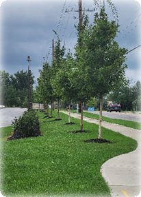
vii) Tree Preservation. Reasonable and good faith efforts will be made to preserve existing trees. Consideration shall be given to laying out service roads, lots, structures, and parking areas to avoid the unnecessary destruction of wooded areas and individual trees. Additionally, standard tree preservation practices must be used to preserve and protect trees during all phases of construction, including the installation of snow fencing at the drip line.
2) In addition to the above standards, the following regulations shall apply:
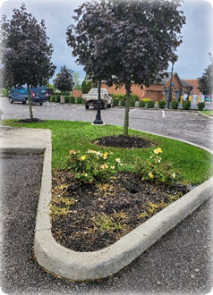
i) Parking Lot Screening. Any surface parking areas adjacent to an existing or planned public right-of-way shall be screened from the respective right-of-way with a minimum of a thirty-six (36)-inch continuous planting hedge and tree combination. The height shall be measured from the adjacent parking area.
ii) Parking Island Landscaping. All parking islands required in Section 11.05(c) shall have a minimum of one shade tree with a minimum of two (2) inches in caliper and include a minimum of fifty (50) square feet of other plant material. The remaining area of the landscaped island shall be covered with stone or planted with grass. The use of mulch shall be prohibited within the landscaped islands.
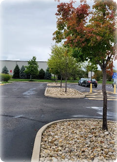
iii) Right-of-Way – Setback Landscape Zone. Throughout the Setback area along an existing or planned public Right-of-Way, there shall be a landscape zone that complies with the following:
A) Arterial Road shall:
I) Minimum of forty (40) feet in depth; and
II) Three (3) foot mound; and
III) A cluster of the following trees at 100-foot intervals for the entire frontage that includes a minimum of three (3) coniferous trees and two (2) deciduous trees.
B) Collector and Local Road Setback Landscape Zones shall be a minimum of ten (10) feet in depth and contain deciduous trees every thirty (30) feet for the entire frontage.
iv) Screening Between Uses. When a mixed-use, multi-unit or commercial buildings abuts a one or two unit dwelling, a continuous planting hedge and tree combination to provide screening between non-residential and residential uses shall be installed. The required planting hedge and tree combination shall be a minimum of five (5) feet in height at the time of installation. Mounding may be used to achieve the required height, and fencing may be incorporated to provide additional screening. Mounding and fencing can only be utilized in addition to and not in lieu of the planting hedge and tree combination.
v) The following regulations shall apply to any development along the public roads:
A) A two hundred (200) foot woodland buffer, when required, shall consist of a minimum of forty (40) feet in width of native vegetation and trees and shall mimic the natural condition of a forest edge for the purpose of greatly reducing noise pollution and visual impacts from development. This forty (40) foot area shall comply with the requirements in Table 11.05(b).
B) The image below shows the ideal woodland buffer where grasses, sedges, and perennials give way to woody shrubs, before finally transitioning to small flowering trees and young canopy trees.
Table 11.05(b): Woodland Buffer
Woodland Buffer Along Major Thoroughfares | |||
|---|---|---|---|
Min. # of trees and shrubs per 100 lineal feet of frontage or fraction thereof shall include the following: | |||
Minimum Buffer Width (Feet) | Min. # of Large Trees | Min. # of Small Trees | Min. # of Shrubs |
40 | 4 | 10 | 33 |
C) All trees required by these regulations, or other applicable standards, shall be live plants and meet the following minimum tree sizes at the time of planting listed in Section 11.05(b)(1)(ii).
D) Trees and shrubs listed in Section 11.05(b)(1)(iii) shall be prohibited as well as any other invasive or undesirable species as listed by the Ohio Department of Natural Resources.
E) Additionally, low maintenance ground covers shall be used for earth berms when earth berms are determined as necessary along an existing roadway. Long-term self-maintaining natural plant communities can be used as low maintenance ground covers for earth berms. Berms shall be discouraged, but when necessary, shall be constructed with a three to one (3:1) slope.
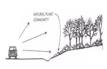
3) Mechanical Equipment, Service Areas, Trash Containers, Loading Zones.
i) Mechanical Equipment. All external mechanical equipment shall be screened from adjacent existing or planned public rights-of-way with materials that are similar to or the same as those used on the adjacent building façade, or with landscaping. This requirement shall include rooftop equipment and ground mounted mechanical equipment.
ii) Service Areas, Production areas, Service areas, Storage Areas, Trash Containers, and Loading Zones. Production areas, service areas, storage areas, trash containers and loading zones shall be located at the rear or the side of the building, except however, these areas are prohibited along a side of a building facing an existing or proposed single-family residential use. These areas shall be effectively screened from all adjacent property lines, existing or planned public rights-of-way and private streets.
iii) Production areas, service areas, and loading zones: Screening of such areas shall consist of either landscaping or walls accented with landscaping materials. Screening consisting of walls shall utilize the same or similar materials as those used on the principals building.
iv) Trash containers and storage areas: Trash containers and storage areas shall be screened on three sides with a solid wall or fence that is a minimum of one foot taller than the trash container or the material within the storage area to be screened. Said wall or fence must be constructed with the same or similar materials as those used on the principal building and must be accented with landscaping. So that the trash container or storage area can be accessed, a solid, decorative gate of the same height as the wall/fence shall be utilized as screening on the fourth side of said trash container or storage area.
v) The use of green infrastructure is encouraged where applicable and may include the use of pervious pavements, green roofs, or rain gardens as approved by the Trustees.
c) Parking and Loading Spaces. Parking lot areas shall be designed and constructed to minimize the visual impact of the parking area, minimize production of excess heat, and prohibit any adverse effects on drainage. Appropriately sized landscaped areas shall be provided within each parking lot area allowing for a variety of shade trees to be planted. To accomplish these goals, all off-street parking lot areas shall be designed and constructed using the “Parking Bay” concept, which consists of parking spaces grouped together, with each Parking Bay separated by landscaped tree islands as further defined in the following sections.
1) Parking Lot Location. All parking lots shall be located behind or to the side of the principal building, except as otherwise provided for herein.
i) Parking lots, when possible, should be located to the side or rear of the principal building. No parking shall be permitted in the required 200-foot minimum setback along public roads.
ii) Parking lots may encroach into a required internal Side or Rear Setback but in no case shall the parking be closer than five (5) feet to internal lot lines, except in cases where the Township Trustees determines that parking lots need to straddle internal lot lines to comply with the connectivity requirements of Section 11.05(d) In such cases, appropriate cross access easements must be established. In no case, shall a parking lot be permitted closer than one hundred (100) feet from a Side or Rear Lot Line, if such lot line abuts an existing or proposed single family residential use.
iii) Parking lots and garages are encouraged to be located underneath buildings to mitigate floodplain disturbance and flooding events.
2) Parking Bays. No Parking Bay shall contain more than forty-eight (48) parking spaces, with a maximum of twenty-four (24) spaces in a single row.
i) Parking Lot Islands. Each landscape island in a single loaded parking stall design shall have a minimum area of 162 square feet with a minimum width of nine (9) feet. Each landscape island in a double loaded parking stall design shall have a minimum of 324 square feet with a minimum width of nine (9) feet.
ii) Parking Lot Screening. All parking lots shall be screened under Section 11.05(b).
iii) Number of Parking Spaces. Every Development Plan within the Mixed-Use Overlay shall include a detailed Parking and Loading Space Plan, which shall comply with these general requirements as well as any specific parking requirements within the applicable standards of this Article. Due to the unique nature of the Mixed-Use Overlay, parking requirements for all development within the Mixed Use Overlay are being established to encourage efficient use of parking areas by establishing a maximum number of spaces required and permitting sensible shared parking to reduce Impervious Surfaces and increase green space. The Total Number of Required Parking Spaces shall be calculated for each separate use within the proposed Development Plan. In no case shall the total number of parking spaces for a particular use be less than the Minimum nor more than the Maximum Number of Required Parking Spaces for said use based upon the below chart. When calculating the required number of spaces, fractional numbers shall be increased to the next whole number.
Table 11.05(c)(1) - Parking
USE | MINIMUM NUMBER OF REQUIRED PARKING SPACES | MAXIMUM NUMBER OF REQUIRED PARKING SPACES |
|---|---|---|
General Retail ‐ Personal Services – Flex Office/Retail | 1 space per 265 square feet | 1 space per 225 square feet |
Restaurants, Bars, Coffee, and Ice Cream Shops | 1 space per 100 square feet | 1 space per 75 square feet |
Library | 1 space per 250 square feet | 1 space per 200 square feet |
Movie Theater | 0.25 spaces per seat | 0.3 spaces per seat |
Hospital/Nursing Home/Hospice | 1 space for every bed plus 1 space for each employee on the largest shift | 1 space for every bed, 4 spaces for every 1,000 square feet of inpatient treatment area, and 5 parking spaces for every 1,000 square feet of outpatient treatment area |
Professional Offices ‐ Open Floor Plan | 1 space per square 175 feet | 1 space per 150 square feet |
Professional Offices – Traditional Floor Plan | 1 space per 300 square feet | 1 space per 250 square feet |
Medical Office | 1 per 225 square feet | 1 space per 200 square feet |
Daycare | 1 space for every 7 children and 1 space for each employee on the largest shift | 1 space for every 5 children and 1 space for each employee on the largest shift |
Assisted Living Facilities | 1 space for every 2.5 Dwelling Units plus 1 space for every 2 employees | 1 space for 2 Dwelling Units plus 1 space for every 2 employees on largest shift |
Independent Senior Living Facilities | 0.85 spaces per Dwelling Unit | 2 spaces per Dwelling Unit |
Multi‐Family Dwelling Units, Townhomes | 1 Space per Dwelling Unit | 3 spaces per Dwelling Unit |
Recreational Uses | ||
Mini‐Golf, Batting Cage | 1 per tee or cage | 1.5 per tee or cage |
Bowling Alley | 3 per lane | 4 per lane |
Recreation/Fitness Centers | 7 spaces per 1,000 square feet | 8 spaces per 1,000 square feet |
Outdoor recreation fields | 50 per field | 75 per field |
Ice or Skating Rink | 1 per 200 square feet | 1 per 150 square feet |
*utilize gross square footage whenever there is a reference to square feet |
|---|
iv) Handicap accessible parking spaces shall be provided under the American with Disability Act requirements.
v) All parking spaces shall be a minimum of nine (9) feet in width and eighteen (18) feet in length measured rectangularly and shall be served by aisleways of a minimum of twenty-four (24) feet in width to permit easy and smooth access to all spaces.
vi) All common areas and adjacent driveways shall be paved with asphalt material or cement and parking spaces shall be striped. Green or pervious pavers/pavement may be approved by the Board of Trustees provided they meet the requirements of the Fire Department and mechanisms for long-term maintenance are provided. The use of gravel for parking lots shall be prohibited.
vii) Mixed-Use Development Parking. When a mix of uses creates staggered peak periods of parking (see Table 11.05(c)(2)), the total parking requirements for the uses in a Development Plan may be reduced up to fifteen percent (15%) below the Total Minimum Parking Requirements for all uses, provided a shared Parking Plan is approved by the Township Trustees during Development Plan approval. The shared parking plan must be based upon the number of originally required spaces for differed uses or facilities sharing the same parking area and documentation that the required parking needed for different uses at different days and times generally based upon Table 11.0(c)(2). Parking spaces included in the shared parking plan must be distributed in a manner that provides parking spaces within a reasonable distance from all proposed uses as determined by the Township Trustees during Development Plan approval. Shared parking must remain under common ownership providing access to all users of the shared parking. If common ownership is not proposed, the Board of Trustees may require documentation of shared access agreements to be provided.
Table 11.05(c)(2) – Peak Parking Periods
Weekday Peaks | Evening Peaks | Weekend Peaks |
|---|---|---|
Banks | Bars | Retails Uses |
Professional Offices | Ice Cream Shops | Movie Theaters |
Medical Offices | Restaurants | |
Library | Movie Theaters | |
Daycare | ||
Coffee Shops |
viii) Loading Spaces.
A) All loading spaces must be located to the side or rear of the principal structure and screened under Section 11.05(b) and are prohibited within any Right-of-Way Setback.
B) A loading space shall consist of a rectangular area adequate for loading and unloading and be accessible from a maneuvering area.
C) All loading spaces and maneuvering areas shall be located on the same Lot as the use they are intended to serve.
D) The required loading space shall have a clearance height of not less than fifteen(15) feet and shall have minimum dimensions of not less than twelve (12) feet in width and fifty (50) feet in length, exclusive of any driveway, aisle, or other circulation area.
E) The number of off-street loading spaces required for various types of uses shall be no less than as set forth in the following:
F) Each use shall provide loading spaces based on gross floor area as follows:
I) Less than 5,000 square feet = None
II) 5,000 square feet - 250,000 square feet = One space
III) Over 250,000 square feet = One space for each 250,000 square feet or portion thereof.
d) Access, Connectivity, and Visibility.
1) All access points shall be limited to those locations approved by the permitting authority (state, county, or township as applicable).
2) Visibility at intersections shall comply with Section 17.22 of this Code.
3) The internal circulation of a parking area shall comply with the Section 11.05(c) of this Code.
4) The overall design within the Development Plan must provide for vehicular connectivity between properties within the Development Plan as well as future connections to adjacent properties outside of the Development Plan boundaries. This requirement could be achieved through access roads (at the rear of the property or running parallel to an existing/proposed public road) and/or through the use of cross-access easements between parking lots. The Township Trustees may rely upon recommendations from the Community’s Engineer to determine that the proposed method for providing connectivity is the most suitable in each particular development.
5) If access roads are utilized to comply with this connectivity requirement, there shall be a minimum distance of 200 feet between intersections or otherwise approved by the Community’s Engineer.
6) Multi-Use Path and Sidewalks. All Collector and Local Roads in all areas of this Overlay District shall have a ten (10)-foot multi use path along each side of the road (within a fifteen (15)-foot MUP easement). All local roads shall have a five (5)-foot sidewalk on both sides of the road within a ten (10)-sidewalk easement which must be located outside of the right-of-way. Curb ramps and crosswalks shall be installed per the American Disability Act requirements. Multi-use paths and sidewalks shall be constructed immediately outside the road right-of-way within a fifteen (15)-foot MUP easement, or ten (10)-foot sidewalk easement designated for such public use.
7) Sidewalks shall connect to the building entrances and to existing sidewalks on adjacent abutting Tracts and to nearby pedestrian destination points including any transit stops.
e) Lighting.
1) All Exterior Lighting shall comply with these standards unless specifically exempted.
2) Exemptions:
i) All exterior lighting fixtures producing light directly by the combustion of fossil fuels, such as kerosene lanterns or gas lamps are exempt from the requirements of this section.
ii) Holiday lighting shall be exempt from the requirements of this section.
iii) All temporary emergency lighting needed by the police, fire department, other emergency service vehicles, and public service vehicles, as well as all vehicular luminaries, shall be exempt from the requirements of this section including flashing or blinking lights.
iv) Street lights shall be exempt from the provisions of this section.
3) Prohibited Lighting. Search lights, beacons, laser source lights, or any similar high-intensity or flashing lights are prohibited, except in emergencies by police and/or fire department personnel.
4) Types of Fixtures. All light fixtures shall be full cut-off type fixtures except for decorative light fixtures.
5) Fixture Height.
i) The fixture height in parking lots shall not exceed twenty (20) feet.
ii) Lighting located under canopies shall be flush mounted or recessed within the canopy.
iii) Fixture height shall be measured from the finished grade to the topmost point of the fixture.
6) Kelvin Levels. The color temperature for each light shall not exceed 4,000K.
7) Exterior lighting shall be designed and located to have the following maximum illumination levels. The levels shall be measured at the finished grade at the Lot Line as demonstrated by a lighting plan:
i) The maximum illumination at a Lot Line that abuts a lot zoned for single family or multi-family uses shall be 0.3 foot-candles.
ii) The maximum illumination at a Lot Line that abuts any other use shall be one (1) foot-candles.
iii) The maximum illumination at a Lot Line for properties used for outdoor sports and recreation shall be reviewed for compliance regarding the intent of these guidelines to minimize the impact of light trespass and glare on all surrounding properties and public rights-of-way.
iv) The illumination across any property shall be designed to not create excessively dark spots that may create safety issues.
v) This subsection applies to any development that abuts a property zoned for One Unit residential purposes.
A) All non–essential outdoor lighting fixtures for non-residential uses, including lighting for parking areas, signs, displays and aesthetic lighting shall be turned off after business hours.
B) Only lighting needed for safety or security may remain lit after close of business, in which case the lighting shall be reduced to the minimum level necessary.
C) Automatic shut-off fixtures, auto-dimming to adjust lighting based on ambient lighting and the use of as little lighting as necessary without creating safety issues is encouraged.
f) Signs. All signs in the Mixed Use Overlay shall comply with the requirements of Article 15 of this Resolution.
h) Utilities, Water and Drainage.
1) All developments shall be served by central water and sewer systems.
2) Dry detention basins are prohibited.
3) All stormwater basins shall be wet basins and aeration devices may be required. Bioretention basins, or rain gardens, may be used only when approved by the Township Trustees.
4) All stormwater requirements must also comply with the Ohio Department of Natural Resources Rainwater and Land Development Handbook, the [Delaware County’s Subdivision Regulations, the Delaware County Soil Erosion and Stormwater Regulations, and any applicable requirements of the Community’s Engineer.
5) A comprehensive regional stormwater plan for each sub area is encouraged.
i) Accessory Structures.
1) In all areas within this Overlay District, Accessory Structures for all uses, except for those on individual lots or parcels shall be identified on and constructed under an approved Development Plan.
2) Accessory Structures must comply with the architectural requirements in Section 17.02 and all setback requirements in this overlay. All Accessory Structures shall be located behind the front plane of the Principal Building. Sheds in all zoning districts that are 100 square feet or less are exempt from these requirements.
Table 11.05(i) - Accessory Structure Requirements
Maximum Height (Feet) | 25 |
|---|---|
Total Maximum Square Footage of Accessory Structures | 10 percent of the Lot Size |
Minimum Distance from Principal Building or any other Accessory Structure (Feet) | 5 |
Minimum Setback from Rear and Side Lot Line (Feet) | 15 (Residential Use) 40 (Commercial Use) |
j) Fences. Fences shall be permitted if they comply with the following regulations:
1) Fences and walls for non-agricultural uses are required to obtain a permit through the application process of Section 3.01. No fence or wall shall be placed on any corner lot to create a sight impediment within seventy-five (75) feet of the intersecting center lines of any two (2) or more streets. In determining if any sight impediment exists, the Zoning Inspector shall measure the sight distance between the center lines of such streets at a height of forty-five (45) inches above the actual grades of the streets.
2) Fences and walls shall not be permitted within any road right of way.
3) Fences and walls shall not be permitted to obstruct any road viewshed.
4) The following types of fences are permitted in front of the front façade provided they do not fully enclose a lot, are used only for decorative purposes and have a maximum height of three (3) feet:
i) Accent Fences
ii) Brick or Stone Walls
iii) Open Fences
iv) Picket Fences
5) The following types of fences are permitted in the side and rear yards and to the rear of the front façade, where they shall have a maximum height of six (6) feet:
i) Accent Fences
ii) Brick or Stone Walls
iii) Chain Link Fences
iv) Open Fences
v) Picket Fences
vi) Wrought Iron Fences
6) Perimeter Fence. A six (6) foot tall perimeter fence may be erected to fully enclose a lot or tract provided it is an Open Fence style, as defined in Article 18.
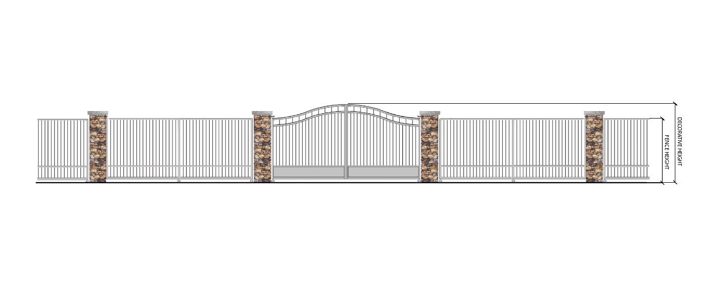
Figure 11.05(j)
7) Privacy Fence. Privacy fences shall be permitted to fully enclose a patio or other similar area immediately adjacent to the primary structure. Privacy fences shall not exceed six (6) feet in height.
8) Buffer Fence. A fence for buffering/screening when required in Section 11.05(b) shall be allowed up to eight (8) feet in height.
9) On lots of less than one (1) acre, electrified fences that follow the property line or parcel boundary shall be prohibited. Electrical fences shall only be permitted on lots of less than one (1) acre if they are located within the required lot setback.
10) No fence or wall shall obscure, hide, or screen fire hydrants, street address numbering, and other security or emergency service equipment, controls, or components, and shall not affect the vision of drivers on the public streets or from driveways intersecting public streets.
11) Prohibited Fencing:
i) Electrified, barbed wire (Except in the LIO), razor wire and stockade fences are prohibited in all districts except for the following situations:
ii) This prohibition shall not be construed to prohibit electrified and/or barbed wire fences when used in conjunction with a purely agricultural use as defined by the Ohio Revised Code.
12) Maintenance.
i) Permitted fences, walls, or structures shall be maintained in good condition, be structurally sound and completely finished at all times. Any grounds between such fences, walls or structures and property lines shall be well maintained at all times by the appropriate property owner. Supporting members for walls and fences shall be located to not be visible from the adjoining property unless the fence is designed such that the supporting members are identical in appearance on both sides of the fence or wall.
ii) Normal repairs and maintenance. None of the provisions of this Code shall be interpreted to prevent normal repairs and maintenance or to strengthen or correct any unsafe condition of any fence.
iii) Non-Conforming Fences and Walls shall be subject to Section 4.07 on damages and continued non-conformity.
k) Home Occupations. Home Occupations shall comply with Section 17.11.
l) Noise. There shall be quiet hours between the hours of 10:00 p.m. and 6 a.m. every day of the week.
ARTICLE 12 – LIGHT INDUSTRIAL OVERLAY (LIO)
12.01 PURPOSE
The Light Industrial Overlay District (LIO) is an overlay district created under Section 519.021(C) and is intended to accommodate light industrial uses and other large employers, such as intense commercial uses like those usually found next to highways like gas stations, large retail, and Drive-Thru Restaurants. This district is also a potential location for TIFs, JEDDs, CEDAs, and/or NCAs.
12.02 OVERLAY ESTABLISHED
The LIO encompasses, includes, overlays, and rezones the area shown on the Zoning Map, which is incorporated herein. The zoning regulations and districts in existence at the time of the effective date of the LIO rezoning shall continue to apply to all property within the LIO, unless the Township Trustees under Sections 3.12-3.19, approves an application submitted by a property owner and/or their agent (the "Applicant"), to subject the provisions of the LIO. Such an application shall be made under the provisions of this Article and all other applicable Articles of this Code.
12.03 PERMITTED USES
a) Within the LIO, only uses listed in Section 8.02 shall be permitted when developed is in strict compliance with the approved Development Plan and the standards of this Resolution. The precise use or type of use of the tract shall be specified in the plan as submitted and approved. Uses listed as permitted in Section 8.02 are allowed by a matter of right. If a use is not designed as permitted in Section 8.02, it shall be considered prohibited.
b) No change in approved use shall be permitted without obtaining approval of a new/revised Development Plan.
c) Temporary Structures. Temporary structures such as manufactured/mobile offices and temporary buildings may be used incidental to construction work on the premises or on adjacent public projects during a period while the permanent structure is being constructed. The user of said structure shall obtain a permit for such temporary use, which permit shall be valid for one (1) year and may be renewed by the Zoning Inspector in three (3) month increments. The Zoning Inspector shall not issue more than two extensions for a total combined period of time under all issued permits not exceeding eighteen (18) months. Renewal of the permit shall be at the discretion of the permanent structure or project. The Zoning Inspector shall require provisions for sanitary waste disposal, solid waste disposal, and water supply, as they deem necessary. The fees for such permit and renewals thereof shall be established by the Board of Townships Trustees. Said temporary structure shall be removed not later than ten (10) days after expiration of said permit.
12.04 LOT SIZE, LOT WIDTH, SETBACK REQUIREMENTS AND DENSITY REQUIREMENTS
Table 12.04 – The standards outlined in this Table shall apply
to all development within the LIO.
LOT SIZE, LOT WIDTH AND SETBACK STANDARDS | |
|---|---|
Use | LIO |
Minimum Tract Size | N/A |
Minimum Lot Size (sq ft) | 40,000 |
Minimum Lot Width | ½ the lot depth |
Minimum Building and Parking Setback from Major Arterial* | 100 |
Minimum Building Setback from Collector Road Right-of-Way Line* | 60 |
Minimum Building Setback from Local Road Right-of-Way Line* | 60 |
Minimum Rear Building Setback* | 25** |
Minimum Side Building Setback* | 25** |
Maximum Building Height† | 60 |
Maximum Lot Coverage | 60% |
* Parking may encroach the Right-of-Way setback under Section 12.05(c).
** When a property abuts an existing structure being utilized for residential purposes, the building and parking setback shall be increased to fifty (50) feet. This includes abutting properties within the LIO that have not yet following the LIO, are following the underlying zoning and contain an existing single-family structure.
† Mechanical and HVAC units may extend above the maximum building height by 10 feet provided such units are screened under Section 12.05(b). This applies to all uses.
12.05 GENERAL DEVELOPMENT STANDARDS.
The general development standards of the LIO shall apply to all new developments, redevelopments, additions, accessory structures, and major site modifications for all uses including, but not limited to, commercial, office, industrial, institutional, religious, governmental, mixed use, and multi-family residential. These general development standards ensure consistency and quality throughout the LIO and each Parcel’s development.
Architectural Requirements. Buildings shall be designed to be seen from 360 degrees and have the same caliber of finish on all elevations. Building additions and accessory structures, whether attached or detached, shall be of similar design, materials, and construction to that of the existing or principal structure. The following standards shall also apply to structures for the following uses:
1) Industrial Uses.
i) Building Scale. The scale of each building shall be aided using articulated building elements such as recesses, offsets, canopies, or other such elements to break up the building mass. Long expanses of exterior walls and any building façade visible from a public right-of-way shall be broken up with architectural design elements, landscaping, or a combination thereof, including but not limited to access bands, texture changes, fenestrations or painted bands or patterns.
ii) The building shall be constructed of one or more of the following materials: Pre-cast concrete, cast stone, pre-cast concrete, wall panel systems, brick, glazed brick, integrally colored, painted, or stained split fact concrete masonry units or brick. No standard concrete masonry unit (cinder block) shall be permitted. EIFS may be utilized as an accent provided it is utilized at eight (8) feet above the finished grade or higher. Pre-engineered metal and pole buildings shall be prohibited.
iii) Canopies. All exterior canopies and entrance features, including loading dock canopies, on a single building shall be a consistent color scheme.
iv) The main building entrance shall incorporate a sufficient amount of glass curtainwall to provide an appropriate scale to the overall building. One color/finish of aluminum curtainwall or window opening framing will be permitted per building. One (1) primary exterior glass color will be permitted per building. Colored spandrel glass may be used as an accent or to conceal interior framing or ductwork. All other colored glass shall be prohibited.
v) Use of Color. Earth tones, muted hues, and natural tones are permitted as a structure’s base color. Brighter hues are permitted only as an accent feature on building elements such as awnings, doors, and trim. A mixed color palette on a single building should be carefully selected so all colors harmonize with each other.
vi) Roofs. Flat roofs are permitted and shall be designed and constructed with positive drainage to prevent water ponding and to shed water in a reasonable time. The slope shall be the minimum recommended by the manufacturer of the proposed roofing systems to achieve proper drainage.
vii) Overhead doors and seals. All overhead doors within a building shall be a single color. No exterior graphics will be permitted on the exterior face of the overhead doors. All dock seals shall be black.
viii) For buildings with Drive-Thrus: A Drive-Thru, if deemed appropriate for the site, shall be designed as an integral part of the structure it serves. Features incorporated with a Drive-Thru including, but not limited to, canopies, awning, and support posts shall match the materials and color scheme of the building they are serving. Drive-Thru features shall not have any pickup windows, ordering areas, signage, or other related items located on the front elevation of a building or located between the building and a street right-of-way.
2) Commercial & Other Uses.
i) Blank walls shall not be permitted. There shall be a minimum of three (3) design elements for every one hundred (100) feet of elevation width for an elevation facing a public Right of Way and a minimum of two (2) design elements for every hundred (100) feet of elevation for each side and rear elevation that does not front on a public right-of-way. Typical design elements are as follows:
A) A door of at least twenty-eight (28) square feet in area with an awning, window, faux window, or other feature subject to approval by the Board of Trustees, as applicable;
B) A window of at least six (6) square feet in area. Windows closer than ten (10) feet shall be considered as one (1) element. A set of adjacent windows, such as double or bay windows, shall be considered one element;
C) Portico;
D) Dormers;
E) Projecting canopy;
F) Masonry water table;
G) Trellis containing plantings;
H) A gabled vent of at least four (4) square feet in area;
I) Patio, deck, or similar feature; or
J) A similar significant permanent architectural feature consistent with the style of the building upon approval of the Board of Trustees as applicable.
ii) All elevations shall have similar style, materials, colors, and details.
iii) Façade Appearance. A building frontage that exceeds a width of fifty (50) feet shall incorporate sectioning and offset of the wall plane to inhibit a large expanse of blank wall and add interest to the façade. Such offsets may be met through using bay windows, porches, porticos, building extensions, gables, dormers, or other architectural treatments.
iv) Materials. All exterior elevations shall be comprised of eighty percent (80%) of wood, fiber cement, and native or cultured stone. Foundations must be clad with the same natural material utilized on the building to blend with the overall architecture of the structure. Exposed cement block or split face block foundations shall be prohibited. Brick or other natural materials may be utilized as an accent material provided it does not exceed twenty percent (20%) of the gross exterior building wall square footage. Vinyl and/or aluminum shall be prohibited except when used for trim details such as downspouts, soffits, gutters, and shutters. The use of black, gold, green, silver, opaque or any other reflective or colored glass on a building is prohibited. Frosted glass may be permitted in some cases, subject to review and recommendation of the Architectural Review Board with final approval of the Board of Trustees.
v) Accent Materials. Fiber cement, E.I.F.S., and like materials may be used as accents provided the total square footage of accent material does not exceed twenty percent (20%) of the gross exterior building wall square footage. Other natural materials may also be incorporated into the building’s exterior design. Vinyl and/or aluminum shall be prohibited except when used for trim details such as downspouts, soffits, gutters, and shutters.
vi) Roofing. Multi-story buildings may be permitted to have flat roofs. When pitched roofs are utilized, they shall be constructed of dimensional shingles, metal, slate, or simulated slate.
vii) In-Line Retail Exemption. Side or rear elevations of an in-line retail development may be exempt from the building design standards of the LIO if such elevations are not visible to customer traffic, a public right-of-way, or if a future phase of the in-line retail development is forthcoming adjacent to the elevation. Such exempt elevations shall use materials complimentary to the primary elevation and be screened by landscaping, mounding fencing, or a combination thereof, as deemed appropriate.
viii) For buildings with Drive-Thrus. A Drive-Thru, if deemed appropriate for the site, shall be designed as an integral part of the structure it serves. Features incorporated with a Drive-Thru including, but not limited to, canopies, awning, and support posts shall match the materials and color scheme of the building they are serving. Drive-Thru features shall not have any pickup windows, ordering areas, signage, or other related items located on the front elevation of a building or located between the building and a street right-of-way.
b) Landscaping: Buffering, Landscaping, Open Space and Screening.
1) The following Requirements apply:
i) Grass (seed or sod), shrubs, trees, garden planting areas or other appropriate landscaping materials shall be planted in all exterior areas. Other groundcover such as ivy, may be planted in exterior areas which are not occupied by required landscaping material or required for drainage.
ii) All trees required by these LIO Development Standards, Example: Street Trees or other applicable standard, shall meet the following minimum tree sizes at the time of planting:
A) Deciduous Tree: two (2)-inch caliper
B) Coniferous Tree: five (5)-feet in height
C) Shrubs and Hedges: Three (3)-feet in height
iii) The following types of trees shall be prohibited:
A) Callery Pear (Pryus calleryana – any cultivar)
B) Tree of Heaven/Ailanthus – (Ailanthus altissima)
C) White Mulberry – (Morus alba)
D) Russian Olive – (Elaeagnus angustifolia)
E) Autumn Olive – (Elaeagnus umbellate)
iv) All plants shall meet or exceed American Standards for nursery stock as set forth by the American Association of Nurserymen.
v) All trees and landscaping shall be well maintained. Dead trees, shrubs, and other landscaping material shall be promptly removed and, when required, shall be replaced within six (6) months.
vi) Tree Preservation. Reasonable and good faith efforts will be made to preserve existing trees. Consideration shall be given to laying out service roads, lots, structures, and parking areas to avoid the unnecessary destruction of wooded areas and individual trees. Additionally, standard tree preservation practices must be used to preserve and protect trees during all phases of construction, including the installation of snow fencing at the drip line.
2) In addition to the above standards, the following regulations shall apply:
i) Parking Lot Screening. Any surface parking areas adjacent to an existing or planned public right-of-way shall be screened from the respective right-of-way with a minimum of a thirty-six (36)-inch continuous planting hedge and tree combination. The height shall be measured from the adjacent parking area.
ii) Parking Island Landscaping. All parking islands required in Section 12.05(c) shall have a minimum of one shade tree with a minimum of two (2) inches in caliper and include a minimum of fifty (50) square feet of other plant material. The remaining area of the landscaped island shall be covered with stone or planted with grass. The use of mulch shall be prohibited within the landscaped islands.
iii) Right-of-Way – Setback Landscape Zone. Throughout the Setback area along an existing or planned public Right-of-Way, there shall be a landscape zone that complies with the following:
A) Arterial Road shall:
I) Minimum of forty (40) feet in depth; and
II) Three (3) foot mound; and
III) A cluster of the following trees at 100-foot intervals for the entire frontage that includes a minimum of three (3) coniferous trees and two (2) deciduous trees.
B) Collector and Local Road Setback Landscape Zones shall be a minimum of ten (10) feet in depth and contain deciduous trees every thirty (30) feet for the entire frontage.
iv) Screening Between Uses. When a proposed use abuts an existing one-unit dwelling, a continuous planting hedge and tree combination or a Buffer Fence shall be installed to provide screening between non-residential and residential uses.. The required planting hedge and tree combination shall be a minimum of eight (8) feet in height at the time of installation. Mounding may be used to achieve the required height, and fencing may be incorporated to provide additional screening.. Buffer Fencing must be a minimum of eight (8) feet in height when mounding and tree combination is not utilized.
3) Mechanical Equipment, Service Areas, Trash Containers, Loading Zones.
i) Mechanical Equipment. All external mechanical equipment shall be screened from adjacent existing or planned public rights-of-way with materials that are similar to or the same as those used on the adjacent building façade, or with landscaping. This requirement shall include rooftop equipment and ground mounted mechanical equipment.
ii) Service Areas, Production areas, Service areas, Storage Areas, Trash Containers, and Loading Zones. Production areas, service areas, storage areas, trash containers and loading zones shall be located at the rear or the side of the building, except however, these areas are prohibited along a side of a building facing an existing or proposed single-family residential use. These areas shall be effectively screened from all adjacent property lines, existing or planned public rights-of-way and private streets.
iii) Production areas, service areas, and loading zones: Screening of such areas shall consist of either landscaping or walls accented with landscaping materials. Screening consisting of walls shall utilize the same or similar materials as those used on the principals building.
iv) Trash containers and storage areas: Trash containers and storage areas shall be screened on three sides with a solid wall or fence that is a minimum of one foot taller than the trash container or the material within the storage area to be screened. Said wall or fence must be constructed with the same or similar materials as those used on the principal building and must be accented with landscaping. So that the trash container or storage area can be accessed, a solid, decorative gate of the same height as the wall/fence shall be utilized as screening on the fourth side of said trash container or storage area.
v) The use of green infrastructure is encouraged where applicable and may include the use of pervious pavements, green roofs, or rain gardens as approved by the Trustees.
c) Parking and Off-Street Loading. Parking lot areas shall be designed and constructed to minimize the visual impact of the parking area, minimize production of excess heat, and prohibit any adverse effects on drainage. Appropriately sized landscaped areas shall be provided within each parking lot area allowing for a variety of shade trees to be planted. To accomplish these goals, all off-street parking lot areas shall be designed and constructed using the “Parking Bay” concept, which consists of parking spaces grouped together, with each Parking Bay separated by landscaped tree islands as further defined in the following sections.
1) Parking Lot Location. All parking lots shall be located behind or to the side of the principal building, except as otherwise provided for herein.
i) Parking lots, when possible, should be located to the side or rear of the principal building. Parking may encroach a right-of-way setback line, but in no case shall parking be less than twenty (20) feet from the road right-of-way line. No parking shall be permitted in the required 200 foot minimum setback along US-33.
ii) Parking lots may encroach into a required internal Side or Rear Setback but in no case shall the parking be closer than five (5) feet to internal lot lines, except in cases where the Township Trustees determines that parking lots need to straddle internal lot lines to comply with the connectivity requirements of Section . In such cases, appropriate cross access easements must be established. In no case, shall a parking lot be permitted closer than one hundred (100) feet from a Side or Rear Lot Line, if such lot line abuts an existing or proposed single family residential use.
iii) Parking lots and garages are encouraged to be located underneath buildings to mitigate floodplain disturbance and flooding events.
2) Parking Bays. No Parking Bay shall contain more than twenty-four (24) parking spaces, with a maximum of twelve (12) spaces in a single row.
i) Parking Lot Islands. Each landscape island in a single loaded parking stall design shall have a minimum area of 162 square feet with a minimum width of nine (9) feet. Each landscape island in a double loaded parking stall design shall have a minimum of 324 square feet with a minimum width of nine (9) feet.
ii) Parking Lot Screening. All parking lots shall be screened under Section 12.05(b).
iii) Number of Parking Spaces. Every Development Plan within the LIO shall include a detailed Parking and Loading Space Plan, which shall comply with these general requirements as well as any specific parking requirements found within this Section. Due to the unique nature of the LIO, parking requirements for all development within the LIO are being established to encourage efficient use of parking areas by establishing a maximum number of spaces required and permitting sensible shared parking to reduce Impervious Surfaces and increase green space. The Total Number of Required Parking Spaces shall be calculated for each separate use within the proposed Development Plan. In no case shall the total number of parking spaces for a particular use be less than the Minimum nor more than the Maximum Number of Required Parking Spaces for said use based upon the below chart. When calculating the required number of spaces, fractional numbers shall be increased to the next whole number.
Table 12.05(c)(1) - Parking
USE | MINIMUM NUMBER OF REQUIRED PARKING SPACES | MAXIMUM NUMBER OF REQUIRED PARKING SPACES |
|---|---|---|
General Retail ‐ Personal Services | 1 space per 265 square feet | 1 space per 225 square feet |
Restaurants, Bars, Coffee, and Ice Cream Shops | 1 space per 100 square feet | 1 space per 75 square feet |
Library | 1 space per 250 square feet | 1 space per 200 square feet |
Movie Theater | 0.25 spaces per seat | 0.3 spaces per seat |
Hospital/Nursing Home/Hospice | 1 space for every bed plus 1 space for each employee on largest shift | 1 space for every bed, 4 spaces for every 1,000 square feet of inpatient treatment area, and 5 parking spaces for every 1,000 square feet of outpatient treatment area |
Professional Offices ‐ Open Floor Plan | 1 space per square 175 feet | 1 space per 150 square feet |
Professional Offices ‐ Traditional Floor Plan | 1 space per 300 square feet | 1 space per 250 square feet |
Medical Office | 1 per 225 square feet | 1 space per 200 square feet |
Flex/Advanced Manufacturing | 2 spaces per 1,000 square feet | 2.5 spaces per 1,000 square feet |
Warehouses | 1 space per employee on largest shift | 1.5 space per employee on largest shift plus 1 space per vehicle stored on site |
Daycare | 1 space for every 7 children and 1 space for each employee on the largest shift | 1 space for every 5 children and 1 space for each employee on the largest shift |
Assisted Living Facilities | 1 space for every 2.5 Dwelling Units plus 1 space for every 2 employees | 1 space for 2 Dwelling Units plus 1 space for every 2 employees on largest shift |
Independent Senior Living Facilities | 0.85 spaces per Dwelling Unit | 2 spaces per Dwelling Unit |
Mixed Use Buildings | 1 Space per Dwelling Unit | 3 spaces per Dwelling Unit |
Recreational Uses | ||
Mini‐Golf, Batting Cage | 1 per tee or cage | 1.5 per tee or cage |
Bowling Alley | 3 per lane | 4 per lane |
Recreation/Fitness Centers | 7 spaces per 1,000 square feet | 8 spaces per 1,000 square feet |
Outdoor recreation fields | 50 per field | 75 per field |
Ice or Skating Rink | 1 per 200 square feet | 1 per 150 square feet |
*utilize gross square footage whenever there is a reference to square feet | ||
iv) Handicap accessible parking spaces shall be provided under the American with Disability Act requirements.
v) All parking spaces shall be a minimum of nine (9) feet in width and eighteen (18) feet in length measured rectangularly and shall be served by aisleways of a minimum of twenty-four (24) feet in width to permit easy and smooth access to all spaces.
vi) All common areas and adjacent driveways shall be paved with asphalt material or cement and parking spaces shall be striped. Green or pervious pavers/pavement may be approved by the Board of Trustees provided they meet the requirements of the Fire Department and mechanisms for long-term maintenance are provided. The use of gravel for parking lots shall be prohibited.
vii) Mixed-Use Development Parking. When a mix of uses creates staggered peak periods of parking (see, Table 12.05(c)(2)), the total parking requirements for the uses in a Development Plan may be reduced up to fifteen percent (15%) below the Total Minimum Parking Requirements for all uses, provided a shared Parking Plan is approved by the Township Trustees during Development Plan approval. The shared parking plan must be based upon the number of originally required spaces for differed uses or facilities sharing the same parking area and documentation that the required parking needed for different uses at different days and times generally based upon Table 12.05(c)(2). Parking spaces included in the shared parking plan must be distributed in a manner that provides parking spaces within a reasonable distance from all proposed uses as determined by the Township Trustees during Development Plan approval. Shared parking must remain under common ownership providing access to all users of the shared parking. If common ownership is not proposed, the Board of Trustees may require documentation of shared access agreements to be provided.
Table 12.05(c)(2) – Peak Parking Periods
Weekday Peaks | Evening Peaks | Weekend Peaks |
|---|---|---|
Banks | Bars | Retails Uses |
Professional Offices | Ice Cream Shops | Movie Theaters |
Medical Offices | Restaurants | |
Library | Movie Theaters | |
Daycare | ||
Coffee Shops |
viii) Loading Spaces.
A) All loading spaces must be located to the side or rear of the principal structure and screened under Section 12.05(b) and are prohibited within any Right-of-Way Setback.
B) A loading space shall consist of a rectangular area adequate for loading and unloading and be accessible from a maneuvering area.
C) All loading spaces and maneuvering areas shall be located on the same Lot as the use they are intended to serve.
D) A required loading space shall have a clearance height of not less than fifteen (15) feet and shall have minimum dimensions of not less than twelve (12) feet in width and fifty (50) feet in length, exclusive of any driveway, aisle, or other circulation area.
E) The number of off-street loading spaces required for various types of uses shall be no less than as set forth in the following:
F) Each use shall provide loading spaces based on gross floor area as follows:
I) Under 10,000 square feet = None.
II) 10,000 square feet or more but less than 75,000 square feet = One space.
III) 75,000 square feet or more but less than 150,000 square feet = Two spaces.
IV) 150,000 square feet or more but less than 300,000 square feet = Three spaces
V) Over 300,000 square feet = One space for each 100,000 square feet or portion thereof.
VI) The loading space requirements for buildings with multiple uses or tenants shall be determined based on the aggregate total of gross floor area of all uses or tenants.
d) Drive-Thru Stacking Requirements.
1) Developments providing an order and Drive-Thru service, pick up window, or other automobile-oriented use on the site shall be designed so that vehicles do not interfere with the parking and movement of other vehicles. Stacking lanes shall be provided to achieve this under the Stacking Requirements table below.
Table 12.05(d) – Drive-Thru Stacking
Activity | Minimum Stacking Spaces (per lane) | Measured From and Including |
|---|---|---|
Banks and ATMs | 3 | Teller/Window or ATM machine |
Restaurant, Coffee Shop, or other similar use | 8 | First pick up window |
Full Service Car Wash* | 20 | Entrance of tunnel |
Self Service – Automated Car Wash | 4 | Washing Bay |
Fuel/Gasoline Pump Island | 1 (at each end of the outermost gas pump island) | Pump Island |
2) Design and Layout:
i) Pump spaces can count toward the stacking space requirement.
ii) Stacking spaces shall be a minimum of nine (9) feet by twenty (20) feet in size.
iii) Stacking spaces may not impede on- or off-site traffic movements or movements in or out of off-street parking spaces. There shall be a separate drive aisle allowing ingress and egress of vehicles that are not waiting in the Drive-Thru lanes.
iv) Stacking spaces shall be separated from other internal driveways by surface markings or raised medians.
v) These stacking space requirements shall be in addition to the off-street parking space requirements.
vi) When adjacent to residential uses, stacking spaces shall be required to be located on sides of the lot opposite the adjacent residential use.
e) Access, Connectivity, and Visibility.
1) All access points shall be limited to those locations approved by the permitting authority (state, county, or township as applicable).
2) Visibility at intersections shall comply with Section 17.22 of this Code.
3) The internal circulation of a parking area shall comply with the Section 12.05(c) of this Code.
4) The overall design within the Development Plan must provide for vehicular connectivity between properties within the Development Plan as well as future connections to adjacent properties outside of the Development Plan boundaries. This requirement could be achieved through access roads (at the rear of the property or running parallel to an existing/proposed public road) and/or through the use of cross access easements between parking lots. The Township Trustees may rely upon recommendations from the Community’s Engineer to determine that the proposed method for providing connectivity is the most suitable in each development.
5) If access roads are utilized to comply with this connectivity requirement, there shall be a minimum distance of 200 feet between intersections or otherwise approved by the Community’s Engineer.
6) Multi-Use Path and Sidewalks. All Collector and Local Roads shall have a ten (10)-foot multi-use path along each side of the road (within a fifteen (15)-foot MUP easement). All local roads shall have a five (5)-foot sidewalk on both sides of the road within a ten (10)-sidewalk easement which must be located outside of the right-of-way. Curb ramps and crosswalks shall be installed per the American Disability Act requirements. Multi-use paths and sidewalks shall be constructed immediately outside the road right-of-way within a fifteen (15)-foot MUP easement, or ten (10)-foot sidewalk easement designated for such public use.
7) Sidewalks shall connect to the building entrances and to existing sidewalks on adjacent abutting Tracts and to nearby pedestrian destination points including any transit stops.
f) Lighting.
8) All Exterior Lighting shall comply with these standards unless specifically exempted.
9) Exemptions:
i) All exterior lighting fixtures producing light directly by the combustion of fossil fuels, such as kerosene lanterns or gas lamps are exempt from the requirements of this section.
ii) Holiday lighting shall be exempt from the requirements of this section.
iii) All temporary emergency lighting needed by the police, fire department, other emergency service vehicles, and public service vehicles, as well as all vehicular luminaries, shall be exempt from the requirements of this section including flashing or blinking lights.
iv) Street lights shall be exempt from the provisions of this section.
10) Prohibited Lighting. Search lights, beacons, laser source lights, or any similar high-intensity or flashing lights are prohibited, except in emergencies by police and/or fire department personnel.
11) Types of Fixtures: All light fixtures shall be full cut-off type fixtures except for decorative light fixtures.
12) Fixture Height:
i) The fixture height in parking lots shall not exceed twenty (20) feet.
ii) Lighting located under canopies shall be flush mounted or recessed within the canopy.
iii) Fixture height shall be measured from the finished grade to the topmost point of the fixture.
13) Kelvin Levels. The color temperature for each light shall not exceed 4,000K.
14) Exterior lighting shall be designed and located to have the following maximum illumination levels. The levels shall be measured at the finished grade at the Lot Line as demonstrated by a lighting plan:
i) The maximum illumination at a Lot Line that abuts a lot zoned for single family or multi-family uses shall be 0.3 foot-candles.
ii) The maximum illumination at a Lot Line that abuts any other use shall be one (1) foot-candles.
iii) The maximum illumination at a Lot Line for properties used for outdoor sports and recreation shall be reviewed for compliance regarding the intent of these guidelines to minimize the impact of light trespass and glare on all surrounding properties and public rights-of-way.
iv) The illumination across any property shall be designed to not create excessively dark spots that may create safety issues.
g) Signs. All signs in the LIO shall comply with the requirements of Article 15 of the Community’s Zoning Resolution.
h) Utilities, Water and Drainage.
1) All developments shall be served by central water and sewer systems.
2) Dry detention basins are prohibited.
3) All stormwater basins shall be wet basins and aeration devices may be required. Bioretention basins, or rain gardens, may be used only when approved by Township Trustees.
4) All stormwater requirements must also comply with the Ohio Department of Natural Resources Rainwater and Land Development Handbook, the Delaware County Subdivision Regulations, the Delaware County Soil Erosion and Stormwater Regulations for Townships, and any applicable requirements of the Community’s Engineer.
5) A comprehensive regional stormwater plan for each sub area is encouraged.
i) Accessory Structures.
1) In all areas within this Overlay District, Accessory Structures for all uses, except for those on individual lots or parcels shall be identified on and constructed under an approved Development Plan.
2) Accessory Structures must comply with the architectural requirements in Section 17.02 and all setback requirements in this overlay. All Accessory Structures shall be located behind the front plane of the Principal Building. Sheds in all zoning districts that are 100 square feet or less are exempt from these requirements.
Table 12.05(i) - Accessory Structure Requirements
Maximum Height (Feet) | 25 |
|---|---|
Total Maximum Square Footage of Accessory Structures | 10 percent of the Lot Size |
Minimum Distance from Principal Building or any other Accessory Structure (Feet) | 40 |
Minimum Setback from Rear and Side Lot Line (Feet) | 40 (Commercial Use) |
m) Fences. Fences shall be permitted if they comply with the following regulations:
1) Fences and walls for non-agricultural uses are required to obtain a permit through the application process of Section 3.01. No fence or wall shall be placed on any corner lot to create a sight impediment within seventy-five (75) feet of the intersecting center lines of any two (2) or more streets. In determining if any sight impediment exists, the Zoning Inspector shall measure the sight distance between the center lines of such streets at a height of forty-five (45) inches above the actual grades of the streets.
2) Fences and walls shall not be permitted within any road right of way.
3) Fences and walls shall not be permitted to obstruct any road viewshed.
4) The following types of fences are permitted in front of the front façade provided they do not fully enclose a lot, are used only for decorative purposes and have a maximum height of three (3) feet:
i) Accent Fences
ii) Brick or Stone Walls
iii) Open Fences
iv) Picket Fences
5) The following types of fences are permitted in the side and rear yards and to the rear of the front façade, where they shall have a maximum height of six (6) feet:
i) Accent Fences
ii) Brick or Stone Walls
iii) Chain Link Fences
iv) Open Fences
v) Picket Fences
vi) Privacy Fences
vii) Wrought Iron Fences
6) Perimeter Fence. A six (6) foot tall perimeter fence may be erected to fully enclose a lot or tract provided it is an Open Fence style, as defined in Article 18.
Figure 12.05(m)
7) Privacy Fence. Privacy fences shall be permitted to fully enclose a patio or other similar area immediately adjacent to the primary structure. Privacy fences shall not exceed six (6) feet in height.
8) Buffer Fence. A fence for buffering/screening when required in Section 12.05(b) shall be allowed up to eight (8) feet in height.
9) On lots of less than one (1) acre, electrified fences that follow the property line or parcel boundary shall be prohibited. Electrical fences shall only be permitted on lots of less than one (1) acre if they are located within the required lot setback.
10) No fence or wall shall obscure, hide, or screen fire hydrants, street address numbering, and other security or emergency service equipment, controls, or components, and shall not affect the vision of drivers on the public streets or from driveways intersecting public streets.
11) Prohibited Fencing:
i) Electrified, barbed wire (Except in the LIO), razor wire and stockade fences are prohibited in all districts except for the following situations:
ii) This prohibition shall not be construed to prohibit electrified and/or barbed wire fences when used in conjunction with a purely agricultural use as defined by the Ohio Revised Code.
iii) Barbed wire fences shall also be permitted in the LIO.
12) Maintenance.
i) Permitted fences, walls, or structures shall be maintained in good condition, be structurally sound and completely finished at all times. Any grounds between such fences, walls or structures and property lines shall be well maintained at all times by the appropriate property owner. Supporting members for walls and fences shall be located to not be visible from the adjoining property unless the fence is designed such that the supporting members are identical in appearance on both sides of the fence or wall.
ii) Normal repairs and maintenance. None of the provisions of this Code shall be interpreted to prevent normal repairs and maintenance or to strengthen or correct any unsafe condition of any fence.
iii) Non-Conforming Fences and Walls shall be subject to Section 4.07 on damages and continued non-conformity.
n) Noise. There shall be quiet hours between the hours of 10:00 p.m. and 6 a.m. every day of the week.
ARTICLE 13 – RESERVED FOR FUTURE USE
ARTICLE 14 – ADULT ENTERTAINMENT FACILITIES
14.01 PURPOSE
The purpose of this Article is to promote the public health, safety, and welfare of the residents of the Township through the regulation of Adult Entertainment Facilities by prohibiting the establishment of such facilities close to existing Adult Entertainment Businesses, residential areas, schools, worship facilities, parks, and playgrounds in the Township.
14.02 EXCEPTIONS
Nothing in this Article shall pertain to:
a) The purchase, distribution, exhibition, and/or loan of any work of art, book, magazine or other printed material or manuscript by an accredited museum, library, fine art gallery, school, museum, or institution of higher learning; and
b) The exhibition and/or performance of any play, drama tableau, or motion picture by any theater, museum, library, fine art gallery, school, or institution of higher learning either supported by public appropriation or which is an accredited institution supported by private funds.
14.03 CRITERIA
Adult Entertainment Businesses shall be considered a Conditional Use in the Light Industrial Overlay District (LIO), and be subject to the following criteria:
a) No Adult Entertainment facility shall be established within 1,000 feet from any of the following:
1) Any school, library, or teaching facility, whether public or private, when such school, library, or teaching facility is attended by persons under eighteen (18) years of age;
2) Any residential dwelling;
3) Any park or recreational facility attended by persons under eighteen (18) years of age;
4) Worship facilities and other similar Places of Assembly (this does not include all “Places of Assembly”); and
5) Another Adult Entertainment Facility.
b) No advertisements, displays or other promotional materials displaying Specified Sexual Activities or specified anatomical areas shall be shown or exhibited to be visible to the public from pedestrian sidewalks or walkways, or from other public or semipublic areas;
c) All building openings, entries, windows, etc., for Adult Entertainment uses shall be located, covered, or serviced in such a manner as to prevent a view into the interior from any public or semi-public area, sidewalk, or street;
d) No screens, loudspeakers or sound equipment shall be used for Adult Motion Picture Theaters (enclosed or outside) that can be seen or discerned from public or semi-public area; and
e) Lighting on the exterior of the building shall be arranged to illuminate the entire off-street parking area.
ARTICLE 15 – SIGNS
15.01 PURPOSE
This Article identifies various types of signs and the districts in which each type of sign would be suitable. This Article also establishes time, place, and manner standards to help appropriately integrate the signs into the intended design and character of each District. Furthermore, this Article is to prevent signs from becoming a distraction or obstruction to the safe and efficient flow of pedestrian and vehicular traffic and to prevent signs from having an adverse impact on adjacent properties or uses to promote the health, safety, and welfare of the residents, drivers, and pedestrians of the Township.
15.02 SIGNS EXEMPT FROM OBTAINING ZONING PERMITS
Unless otherwise exempted below, a Zoning Permit shall be obtained prior to erecting any sign in any district. The following types of signs are exempt from obtaining a Zoning Permit:
a) Signs not exceeding two (2) square feet in area that are customarily associated with a residential use and are not of a commercial nature, including the address and/or the name of the occupants;
b) Signs erected by a governmental entity for a recognized public purpose and duly authorized by any law, statute, or code. Such Signs include legal notices and traffic control devices, provided such signs carry no supplementary advertising;
c) Signs that are on the inside of a structure or building that are designated or located to not be typically visible from outside the window. This does not include:
1) Signs that are not affixed to the window but can be seen from outside the window. Such signs shall be considered as Temporary Signs as defined in Article 18 and shall be regulations per Section 15.15; and
2) Signs that are physically affixed to or painted on to the window – such signs are considered Window Signs as defined in Article 18 and shall be regulated per Section 15.08.
d) Temporary Signs clearly in the nature of decorations customarily associated with a national, local, or religious holiday. Such Signs shall be of any illumination or animation provided that a safety and/or visibility hazard is not clearly created; and
e) All signage and graphics shall be carefully coordinated with the building and architecture.
15.03 REGULATIONS FOR ALL SIGNS
The following regulations apply to all Signs within the Township:
a) No part of any Sign shall extend higher than the eave of any building, except when placed on the parapet of a building;
b) Each building and unit, if applicable, shall have an address number that is clearly visible from the public right-of-way. Such Signs shall not require a permit; and
c) Original Art Mural and Vintage Art Murals as defined in Article 18 – Definitions, shall only be permitted under Section 15.17 these regulations.
d) If a sign is to be installed into the ground, the owner of the lot should consider contacting 811/Ohio Utilities Protection Service 48-hours prior to installation as a safety precaution.
15.04 PROHIBITED SIGNS
The following signs are prohibited:
a) Signs painted directly on the surface of a fence;
b) Roof signs and roof mounted sign;
c) Portable displays or mobile display (except sandwich board signs);
d) Any sign painted directly on the surface of a fence;
e) Roof signs or roof mounted signs shall be prohibited. No part of any sign shall extend higher than the eave of any building, except when placed on the parapet of a building;
f) Any sign that resembles or is intended to resemble a traffic control device or is located in such a manner to obscure or impact the effectiveness of such traffic control device or signal, under ORC Section 4522.26 and Section 17.22 of the Township;
g) Any permanent or temporary sign located on a utility pole, public signpost or otherwise displayed within the public right-of-way, under Section 17.22 of the ORC, except as may be specifically controlled herein; and
h) Feathered flags;
i) Any sign that obstructs any part of a direct access doorway, exit or fire escape;
j) Portable displays or mobile signs that are not anchored or secured to prevent collapse or unintended movement;
k) Any sign located within the Sight Visibility Triangle in Section 17.22;
l) Gas or air-filled devices, revolving or rotating signs, exposed neon signs, exposed LED signs, signs with flashing messages or bare bulbs, flashing or high intensity lights mounted on a sign, signs on backlit awnings, or signs with moving text or pictures; and
m) Projecting Signs
15.05 CANOPY SIGNS
All Canopy Signs shall comply with the following requirements:
TABLE 15.05
CB | Planned Districts | |
|---|---|---|
Maximum Number of Signs Per Business | 1 | Per Approved Development Plan |
Maximum Square Footage | 2 sf/lf of canopy | Per Approved Development Plan |
Maximum Height (Feet) | 15 | Per Approved Development Plan |
Minimum Height (Feet) | 9 | Per Approved Development Plan |
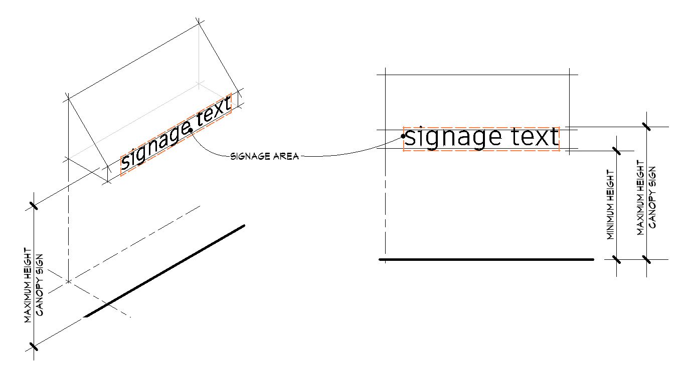
15.06 GROUND SIGNS
All ground signs shall comply with the following requirements:
TABLE 15.06
FR/RR | CB | Planned Districts | |
|---|---|---|---|
Maximum Number of Signs Permitted Per Public Road Frontage | Not allowed | 1 | Per Approved Development Plan |
Maximum Square Footage | Not allowed | 40 | Per Approved Development Plan |
Maximum Height (Feet) | Not allowed | 8 | Per Approved Development Plan |
Minimum Distance from ROW (Feet) | Not allowed | 20 | Per Approved Development Plan |
a) The maximum square footage Table 15.13 is per sign face. Each sign face shall count towards the maximum size of the sign and total maximum square footage of all signs. There shall be a maximum of two (2) Sign faces per Sign.
b) All Ground Mounted Signs shall have a solid base consistent with the primary building material and have a minimum of fifty (50) square feet of landscaping around all sides of the Ground Mounted Sign. Sign shall be affixed directly to a base having a width at least equal to that of the sign.
c) Ground Mounted Signs shall not be permitted along real access roads.
Measurement of Ground Mounted Sign Area and Height:
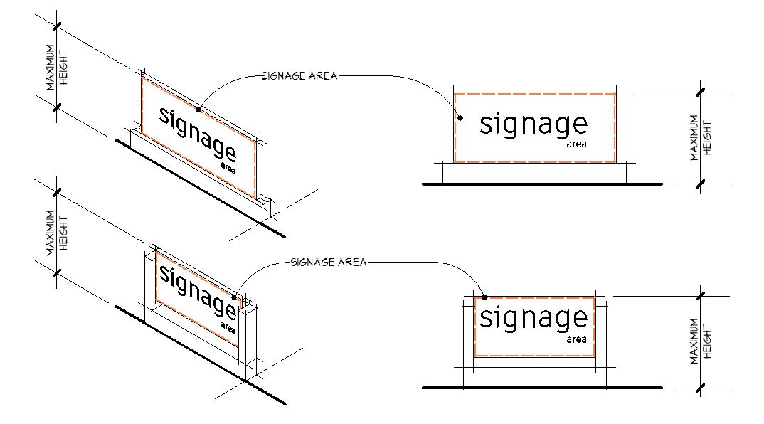
15.07 WALL SIGNS
All wall signs shall comply with the following requirements:
TABLE 15.07
FR/RR (when associated with a Conditional Use) | CB | Planned Districts | |
|---|---|---|---|
Maximum Number of Signs Permitted Per Public Road Frontage | 1 | 1 | Per Approved Development Plan |
Maximum Square Footage | 12 | 2 sq. ft. per 1 lineal foot of building width | Per Approved Development Plan |
Maximum Height (Feet) | 15 | Height of Eave | Per Approved Development Plan |
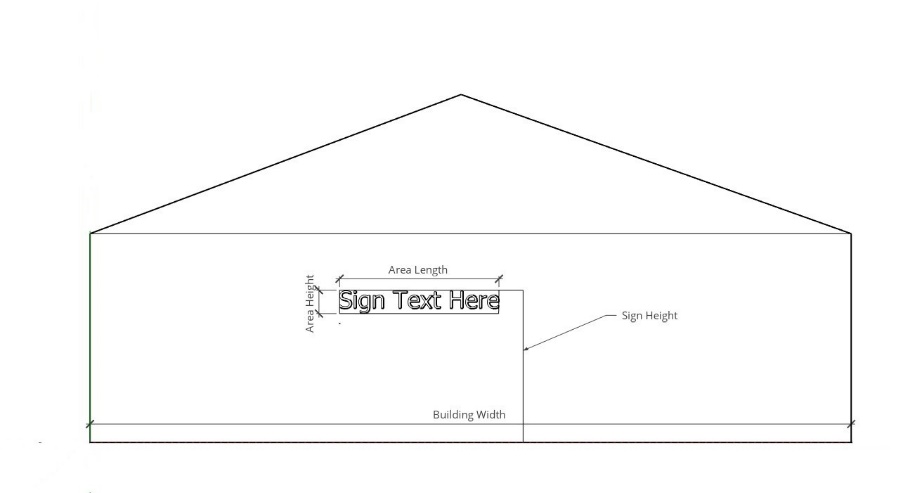
15.08 WINDOW SIGNS
All window signs shall comply with the following requirements:
TABLE 15.08
FR/RR (when associated with a Conditional Use) | CB | Planned Districts | |
|---|---|---|---|
Maximum Number of Signs Permitted | 1 per lot | 1 per window | Per Approved Development Plan |
Maximum Square Footage | 10 percent of window area | 25 percent of window area | Per Approved Development Plan |
Maximum Height (Feet) | 15 | 15 | Per Approved Development Plan |
15.09 PYLON SIGNS
All pylon signs shall comply with the following requirements:
TABLE 15.09
CB | Planned Districts | |
|---|---|---|
Maximum Number of Signs Permitted Per Public Road Frontage | 1 | Per Approved Development Plan |
Maximum Square Footage | 125 | Per Approved Development Plan |
Maximum Height (Feet) | 35 | Per Approved Development Plan |
Minimum Distance from ROW (Feet) | 20 | Per Approved Development Plan |
Measurement of Pylon Sign Area and Height:
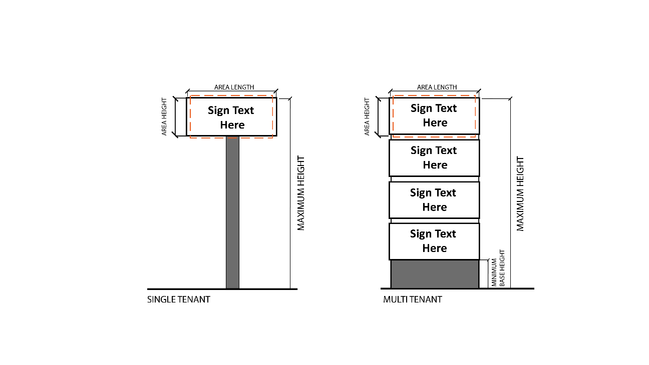
15.10 DIRECTIONAL SIGNS
There may be two directional signs per access driveway connecting to a public or private street. Directional signs shall be limited to a maximum height of three (3) feet, a maximum area of six (6) square feet per side and shall be located outside of the right-of-way and on the property of the user(s) of which they are identifying the entry or exit.
15.11 ENTRANCE WALL SIGN
a) One (1) sign may be placed on an entrance wall or on each parallel entrance wall as permitted in Section 15.06.
b) Lighting for said sign(s) shall be restricted to external illumination that complies with Section 15.14. Internal illumination of said signs are prohibited.
c) Each sign shall not extend above the height of the wall and shall not exceed the following maximum area:
TABLE 15.11
District | Max Area (sq ft) |
|---|---|
CB / LI | 20 |
Planned | Per Approved Development Plan |
15.12 DRIVE-THRU SIGNS
Signs accessory and adjacent to Drive-Thru food and beverage establishments, car washes, and other similar uses are subject to the following standards:
a) One large Drive-Thru board shall be permitted per Drive-Thru lane. Said sign shall not exceed fifty (50) square feet, must be located a minimum of one (1) foot from and a maximum of five (5) feet from the edge of pavement of the Drive-Thru lane to which it serves and shall not exceed eight (8) feet in height.
b) One medium Drive-Thru board shall be permitted per Drive-Thru lane. Said sign shall not exceed fifteen (15) square feet in area, must be located a minimum of one (1) foot and a maximum of five (5) feet from the edge of pavement of the Drive-Thru lane to which is serves and shall not exceed eight (8) feet in height.
c) One small Drive-Thru sign board shall be permitted per Drive-Thru lane shall be permitted. Said sign shall not exceed two and half (2.5) square feet area, must be located on the Drive-Thru speaker and shall not exceed five (5) feet in height.
d) Drive-Thru board signs shall be permitted to have changeable copy electronic display messages may be permitted provided the graphics and/or words on the sign change no more than once per car service. Video, flashing images or effects, or moving content shall be prohibited.
15.13 TOTAL MAXIMUM SQUARE FOOTAGE OF ALL SIGNS
TABLE 15.13
Total Maximum Square Footage for All Signs | |
|---|---|
CB / LI | 400 for internal lots 500 for corner lots or double frontage lots |
PLANNED DISTRICTS | Per Approved Development Plan |
15.14 SIGN LIGHTING
Sign lighting shall be consistent, understated, and properly disguised. Unless noted in this code, one of the following methods of lighting may be employed:
a) A white, steady, stationary light that does not glare onto surrounding areas, is directed solely at the Sign, and is otherwise prevented from beaming directly onto adjacent properties or rights-of-way; or
b) A white interior light with primary and secondary images lit or silhouetted on an opaque background. The background must be opaque. No additional background lighting or illuminated borders or outlines shall be permitted.
1) The color temperature of the sign lighting shall not exceed 4,000K.
2) The level of illumination emitted or reflected from a Sign shall not be of an intensity sufficient to constitute a demonstrable hazard to vehicular traffic on any Right of Way or parking lot from which the sign can be viewed.
3) Light fixtures shall be screened from view by site grading or landscaping.
15.15 TEMPORARY SIGNS
The following Temporary Sign regulations apply to all uses within all areas within this Overlay District:
a) Temporary Signs shall be prohibited within the right-of-way.
b) In all residential zoning districts, three (3) Small Temporary Signs shall be permitted per parcel per street frontage without a permit. In all other zoning districts, up to six (6) Small Temporary Signs shall be permitted per parcel per street frontage without a permit. Each Small Temporary Sign shall be seven (7) square feet in area or less and less than three (3) feet in height.
c) In all districts, one (1) temporary banner is permitted per parcel per street frontage without a permit. Each temporary banner shall not exceed eight (8) feet in height and thirty-two (32) square feet in area and shall not be displayed for more than fourteen (14) days within any one hundred eighty (180) day period
d) In the CB and MU Districts, two (2) Large Temporary Signs shall also be permitted per parcel provided a Sign permit is issued under the following regulations. Large Temporary Signs shall not:
1) Exceed eight (8) feet in height;
2) Exceed thirty-two (32) square feet in area (per Sign face); and
3) On parcels of five (5) acres or less, such signs shall be displayed for no more than thirty (30) consecutive days and no more than three (3) times per calendar year. A new permit must be obtained for each thirty (30) day or less period. After said permits have been exhausted, the Zoning Inspector may grant one (1) extension for up to ninety (90) days per Sign. No other extensions may be administratively approved and must be approved by the Board of Zoning Appeals. On parcels that are greater than five (5) acres, such signs may be displayed for up to one-hundred eighty (180) days. Upon the expiration of this permit, the Zoning Inspector may grant one (1) extension up to an additional one-hundred eighty (180) days. No other extensions may be administratively approved and must be approved by the Board of Zoning Appeals. In no case, shall such signs be erected for more than three hundred sixty-five (365) days.
e) Small and Large Temporary Signs and Temporary Banners shall not count toward the total maximum square footage of signs permitted on a lot.
f) The sign permit number for Large Temporary Signs must be printed on the sign in a visible location.
15.16 CHANGEABLE COPY AND ELECTRONIC MESSAGE DISPLAYS
These Changeable Copy and Electronic Message Display standards are applicable to all signs, except Drive-Thru boards since the purpose of those boards are to service those utilizing the Drive-Thru lane where cars are typically stopped to view said sign. All other changeable copy and electronic messaging displays shall:
a) Be limited to fifty percent (50%) of the overall sign area and have no more than one (1) sign on the lot;
b) Be static, shall not move, scroll, or flash, and shall not change more than one (1) time every eight (8) seconds;=
c) In no case shall the brightness of the sign exceed a maximum of 0.3 footcandles as measured from the lot line of an abutting lot where a residential land use is located.
15.17 VINTAGE MURALS AND WALLSCAPES
All murals created prior to the date of adoption of this code shall be considered existing non-conforming and may be maintained under Article 4 of this code.
15.18 BILLBOARDS
Billboard shall be permitted in the FR, GB, and LIO Districts, and shall be subject to the following conditions:
a) Billboards shall be allowed only on properties having direct frontage on state or federal highways designated as on the primary system. Not more than one (1) billboard shall be allowed on any single property existing as of the effective date of this amendment. The erection of all billboards shall comply with all federal and state requirements;
b) Any billboard shall maintain a maximum height of forty-five (45) feet. The maximum display area for any billboard shall not exceed 300 square feet per side;
c) Said billboard structures must be setback from the established right-of-way of any roadway not less than one hundred (100) feet;
d) At a property at any intersection, any billboard structure shall not be located less than 200 feet from the established right-of way line of each highway or thoroughfare, or in such other manner as to interfere with, or obstruct clear vision of such intersection in any direction for a distance of 250 feet;
e) No such billboard structure shall be permitted to face the front or side lot line of any lot or parcel of land that abuts a district that permits residential uses and is within 300 feet of such lot line; and
f) No billboard shall be erected within 1,500 feet from any other billboard.
ARTICLE 16 – PARKING
16.01 PURPOSE
The purpose of this Article is to encourage the orderly development of parking areas within the Township and to promote the safety of residents and visitors by insuring the efficient handling of vehicular traffic.
16.02 PROVISION FOR PARKING REQUIRED
Unless otherwise indicated in this Code, in all zoning districts, off-street parking requirements shall be under this Article.
16.03 GENERAL REQUIREMENTS
a) Surfacing and Drainage. All off-street parking areas for commercial or industrial projects within the CB, MU, and LIO Districts shall be properly graded, marked, and surfaced to provide a hard, durable, and dustless surface. All parking areas shall be graded and drained to dispose of surface water which might accumulate within or upon such area and shall be designed to prevent the excessive drainage of surface water onto adjacent properties or public roadways. The developer of the project shall demonstrate that adequate provisions have been made to direct storm runoff to a suitable and adequate storm water drainage system.
b) Lighting. Any lighting used to illuminate any off-street parking area shall be so arranged as to reflect light away from any adjoining premises in any zoning district where residences are a permitted use. In addition, such lighting shall be so arranged as not to interfere with traffic on any adjoining street or to be confused with any traffic control lighting. Other provisions in Section 17.14 also apply.
c) Location of Parking Spaces. A five (5) foot clear zone shall be maintained between the roadway right-of-way and any parking space. Parking areas shall be so designed and arranged so as not to allow the protruding of any vehicle (or portion thereof) over the clear zone.
d) Parking of Inoperable or Disabled Equipment or Vehicles. The exterior parking or storage of inoperable, unlicensed, or disabled pieces of equipment or vehicles for a period of time exceeding thirty (30) consecutive days, outside of an approved junk yard licensed and regulated under Sections 4737.05-12 of the ORC, shall be prohibited. The Township reserves the right to remove junk cars from private property under Section 4513.65 of the ORC.
e) Landscaping, Parking Bays, and/or Parking Lot Islands. See, Section 17.12.
f) Parking of Recreational Equipment. The storage of travel trailers, motor homes, pick-up campers, folding tent trailers, boats or boat trailers and similar recreational equipment shall be subject to the following requirements:
1) Not more than two (2) pieces of such equipment, or vehicles, shall be permitted to be stored outside on a parcel containing a single family or two-family dwelling. For the purpose of this Section, a boat stored on a boat trailer shall be deemed one piece of recreational equipment;
2) Recreational equipment shall not be used for permanent occupancy; and
3) Recreational equipment may be used for temporary occupancy for a period of time not exceeding three (3) months.
16.04 JOINT-USE PARKING
Two (2) or more uses may jointly provide and use parking spaces, provided that together they meet the parking space requirements of Section 16.06.
16.05 PUBLIC PARKING FACILITIES
a) Property within a 500-foot radius of a public parking facility shall not be required to provide or maintain a specific number of off-street parking spaces. All other properties shall conform to Section 16.06, below.
b) Public parking facilities shall not be required to provide a specific number of parking spaces. However, the Zoning Commission can recommend a desired number of parking spaces based on expected traffic.
16.06 SCHEDULE OF REQUIRED OFF-STREET SPACES
Parking spaces shall be provided according to the following schedule of uses. If a use consists of more than one component use (such as a school with a stadium) the required minimum number of parking spaces shall be the sum of the required spaces for those component uses. For uses not listed, the Board of Zoning Appeals shall determine the number of required spaces, based on comparing the proposed use with similar uses listed in the schedule:
a) Residential. One (1) parking space for every residential dwelling unit on a property.
b) Commercial. One (1) parking space for every one hundred (100) feet in Gross Floor Area with the following exceptions:
1) Campground: One (1) per each campsite and one per employee for the largest shift;
2) Hotels and Motels: One (1) per sleeping room; and
3) Office: Four (4) spaces per 1,000 square feet in Gross Floor Area.
c) Institutional. One (1) parking space for every 500 feet in Gross Floor Area with the following exceptions:
1) Assisted living, nursing homes, and hospitals: One (1) for each employee on the largest shift and one (1) for every four (4) beds;
2) Places of assembly: One (1) for every six (6) seats in the main area of assembly.
3) Schools: One (1) for every ten (10) students and one (1) for each employee on the largest shift; and
4) Daycares: One (1) for each employee on the largest shift.
d) Industrial. One-half (½) space per 1,000 square feet in Gross Floor Area and/or one (1) for each employee on the largest shift.
16.07 LOADING SPACES
a) All loading spaces must be located to the side or rear of the principal structure and screened under Section 17.12 and are prohibited within any front yard;
b) A loading space shall consist of a rectangular area adequate for loading and unloading and be accessible from a maneuvering area;
c) All loading spaces and maneuvering areas shall be located on the same Lot as the use they are intended to serve;
d) A required loading space shall have a clearance height of not less than fifteen (15) feet and shall have minimum dimensions of not less than twelve (12) feet in width and fifty (50) feet in length, exclusive of any driveway, aisle, or other circulation area;
e) Each loading space shall have minimum dimensions not less than twelve (12) feet in width, fifty (50) feet in length, and a vertical clearance of not less than fifteen (15) feet.
f) Off-street loading spaces may occupy any part of a required rear or side yard, but shall not project into any front yard;
g) All required, off-street loading spaces should have access to a public street in such a manner that any vehicle leaving or entering the premises shall be traveling in a forward motion;
h) All required loading spaces, together with driveways, aisles, and other circulation areas, shall be surfaced with an asphaltic concrete or Portland cement concrete pavement to provide a durable and dust free surface;
i) All loading spaces, together with driveways, aisles, and other circulation areas, shall be designed to prevent the drainage of surface water onto adjacent properties or walkways and damage to public streets;
j) Screening shall be required as provided in Section 17.12;
k) Any loading area, which is intended to be used during non-daylight hours, shall be properly illuminated to avoid accidents. Any lights used to illuminate a loading area shall be so arranged as to reflect the light away from adjoining property;
l) No loading ramp, dock, door, or space, nor any portion thereof, shall be located closer than fifty (50) feet from any lot zoned for residential use;
m) For uses in excess of 10,000 square feet of gross floor area one (1) additional off-street loading space shall be required for each additional 20,000 square feet of gross floor area or fraction thereof; and
n) The number of off-street loading spaces required for the CB District shall be no less than as set forth in the following:
1) Less than 5,000 square feet in Gross Floor Area: None required;
2) 5,000 to 250,000 square feet in Gross Floor Area: One (1) space; and
3) Over 250,000 square feet in Gross Floor Area: One space for each 250,000 square feet in Gross Floor Area.
ARTICLE 17 – GENERAL DEVELOPMENT STANDARDS
17.13 Large Residential Facilities, Emergency & Protective Shelters, Transitional Living Centers, & Permanent Supportive Housing
17.01 ACCESSORY DWELLING UNITS
a) Applicability. The standards apply to any Residential District where ADUs are listed as a Permitted or Conditional Uses.
1) Number. Only one (1) ADU shall be permitted on a lot.
2) Density. ADUs do not count toward the density calculations for the District in which they are located.
3) Accessory Suite (Attached) Standards. All Accessory Suite ADUs shall comply with the following general ADU design standards:
i) An ADU must be attached to the primary structure through either a common wall or breezeway;
ii) The primary dwelling in which the ADU is located shall be owner occupied;
iii) An ADU may be no larger than eight hundred (800) square feet or the size of the primary dwelling unit, whichever is less;
iv) ADU's shall be limited to residential uses including a Minor Home Occupation and shall not be utilized for any other purpose;
v) One additional parking space is required for the ADU;
vi) No new entrances into the primary dwelling shall be created for the Accessory Suite ADU; and
vii) Any required fire escapes or exterior stairs for access to an upper-level Accessory Suite ADU shall not be located along the front façade of the primary dwelling.
4) Detached ADUs. Detached ADUs are prohibited in the Township.
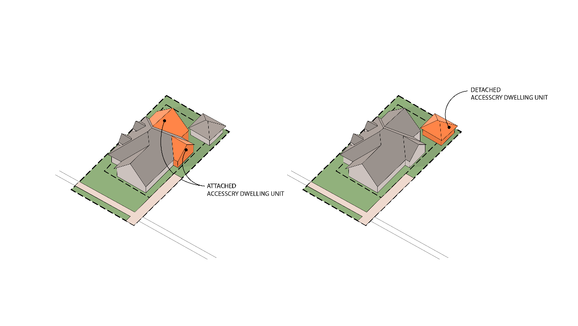
17.02 ACCESSORY USES AND STRUCTURES
Applicability. These standards shall apply to all Accessory Structures, except Private Swimming Pools.
Location. All accessory structures occupying less than five (5) acres shall be in conformity with the following provisions:
The Accessory Structure shall comply with the minimum setback requirements of the applicable Zoning District.
Accessory structure may not be erected within fifteen (15) feet from the Primary Structure;
Height. No accessory building in any district shall exceed twenty-five (25) feet in height.
Location.
On a parcel of less than one (1) acre, the number of accessory structures, excluding gazebos, or picnic shelters, shall be limited to one (1) and shall not exceed six hundred (600) square feet;
On a parcel of one acre or more but less than five (5) acres, the number of accessory structures, excluding gazebos, or picnic shelters shall be limited to two (2) structures. The maximum floor area of any single accessory building and the maximum of all accessory structures combined shall not exceed twelve hundred (1200) square feet.
Figure 17.02 – Accessory Uses | ||
|---|---|---|
Acreage | ||
Acreage Less than 1 acre | 1 acre or more, but less than 5 | |
Location | Cannot be located within fifteen (15) feet of the Primary Structure. Must comply with the minimum setback requirements of the applicable Zoning District. | |
Maximum Number of Accessory Structure | One (1) Accessory Structure | Two (2) Accessory Structures |
Maximum Square Footage | Six Hundred (600) Square Feet | Twelve Hundred (1,200) Square Feet |
Height | Twenty-Five (25) Feet | |
17.03 AGRITOURISM
Purpose. It is the purpose of this section to regulate Agritourism under the limitations of ORC Sections 303.21(C)(4) and 519.21(C)(4) of the Ohio Revised Code permits the Township Zoning Resolution to regulate Agritourism structures and property as necessary to protect the public health, safety, and general welfare. The following regulations apply to the “size of structure used primarily for agritourism, size of parking areas that may be required, setback building lines for structures used primarily for agritourism, egress or ingress where such regulation is necessary to protect public health and safety.”
Declaration of Intent – Agricultural Exemption.
In order to qualify for an Agricultural Exemption from obtaining a Zoning Certificate for Agricultural Uses, an applicant must submit a “Declaration of Intent – Agricultural Exemption Form.” This form will be considered by the Zoning Inspector and if granted, the applicant will not be required to have an Conditional Use Permit on file regarding the Agritourism use. A Conditional Use Permit is required to demonstrate compliance with the standards for Setbacks, Structure size, height, parking, and other elements authorized by ORC Section 519.02 and listed herein.
The applicant shall provide documentary evidence to the Zoning Inspector that the farm upon which the Agritourism operation is proposed meets all of the requirements of ORC Section 901.80 with regards to liability.
Site Plan Requirements. In order to qualify for an Agritourism Exemption, the applicant shall be required to provide a property site plan to the Zoning Inspector that clearly shows the location, Setbacks, parking areas, plan for ingress and egress from the structure as well as for traffic entering and leaving the parking area and the size of the exempted Structure.
No Agricultural Exemption will be granted that does not comply with the requirements of the Setbacks and size of the Structure as outlined under the Zoning District in which it is located.
All Buildings and Structures primarily used for Agritourism shall not exceed the maximum building square footage requirements established for the Zoning District in which it is located. Should no maximum building square footage be established by the District, the maximum square footage for said Building or Structure shall be five thousand (5,000) square feet.
All Buildings and Structures utilized primarily for Agritourism shall not exceed thirty-five (35) feet in height.
The property site plan must provide information necessary to evaluate that the ingress and egress from the Structure meets all public safety requirements as established by the Ohio Fire Code and enforced by the Fire Department. Information necessary for the property site plan shall be submitted with one (1) physical copy and electronically in PDF format and shall include the following on the drawing:
The site plan drawn to a scale that is legible in print and electronic formats;
A scale bar and the written scale (Ex.: 1” = 100’);
A north arrow;
A table that specifies the number of parking spaces, the dimension(s) of the parking spaces, the dimensions of the Structure for all floors, including garages and basements;
The depiction of the parking spaces that must comply with Article 16;
The depiction on the drawing of the drive lanes and the dimension of the overall area of the parking area;
The dimension of the Driveway Throat Length measured from the edge of the road Right-of-Way to the point where the Driveway Throat turns into any parking stall or internal drive lane; and
The location and dimension of the Building footprint, the required Yard Setback Lines, the road Right-of-Way, and the Lot Lines based on the recorded legal description.
The property site plan must provide the information above to evaluate the ingress and egress to and from the parking area and the site plan meets all public safety requirements as established by the Township or the County, as applicable.
Parking. All parking demands created by the Agritourism Use shall be met off Public Roads. In no case shall any portion of any Public Road pavement be used for or considered customer parking to serve an Agritourism operation. Parking areas shall adhere to the following Setback requirements:
Fifty (50) feet from any Lot boundaries;
A minimum setback of fifty (50) feet for any parking stall or internal drive lane from the road Right-of-Way to the point where the Driveway Throat connects to the parking stall or internal drive lane. Parking areas shall be set back a minimum of six (6) feet from any Driveway Throat. The purpose of which is to preserve the Driveway Throat Length to allow adequate area for vehicles to enter the site and make maneuvers during the peak hour trip generator for the site and not cause back up onto the Public Road. A great Driveway Throat Length may be necessary for larger trip generators and may be required by other government agencies including regulations from the Ohio Department of Transportation Access Management and/or Location and Design Manual, and any standards established by the Delaware County Engineer’s Office
Additional Standards.
The applicant shall submit evidence to the Zoning Inspector that the ingress and egress to and from the parking area has been approved by the County Engineer and/or the Ohio Department of Transportation. Additionally, the applicant shall provide written documentation that the access and access location(s) complies with the Delaware County Subdivision Regulations and other infrastructure-related standards adopted by the Delaware County Planning Commission, as applicable.
The applicant shall specifically provide documentary evidence to the Zoning Inspector that identifies the educational, entertainment, historical, cultural, and/or recreational relationship of the proposed Agritourism operation to the existing Agricultural Use of the property.
Wedding Venues, as defined in Article 19, located on an Agritourism Operation property shall be required to be on a Lot with a minimum of twenty (20) acres in order to help promote the health, safety, and general welfare of the surrounding community.
17.04 BOARDING KENNELS
a) Purpose. The purpose of this section is to provide regulatory information regarding Boarding Kennels, as defined in Article 18, designed only for the boarding of animals. The purpose of these requirements is to reduce noise levels from barking dogs to comply with the Township’s nuisance regulations adopted by separate resolution.
b) General.
1) Indoor Boarding Kennels. Indoor Boarding Kennels with access to outdoor runs shall have solid doors between indoor and outdoor areas that are closed between the hours of 8:00 p.m. and 8:00 a.m. and all other non-business hours. All Boarding Kennels shall be contained within the principal structure and shall be separated from the exterior of the Building by a solid wall and door.
2) Outdoor Boarding Kennels. Outdoor Boarding Kennels that are located only outdoors are prohibited.
3) Outdoor Runs. All outdoor runs shall be closed between the hours of 8:00 p.m. and 8:00 a.m. and all other non-business hours. All animals shall be housed inside the principal structure during these hours.
i) All outdoor runs shall be separated by a solid eight (8) foot wall so as an animal in one outdoor run does not see an animal in another. The purpose of this requirement is to reduce the tendency of animals to bark or fight with other animals in adjoining runs.
ii) All outdoor runs shall be located behind the principal Structure and shall be maintained at least three hundred (300) feet from adjacent Lot Lines.
4) Perimeter Fencing. An eight (8) foot tall perimeter fence shall be constructed to prevent any animal from escaping the premises. Said Fence shall be constructed of solid, durable materials. Chain Link Fencing and Chain Link Fencing with materials woven into the fencing are not permitted. The Board of Zoning Appeals may determine the area for the Perimeter Fencing based upon the area of use. Said Perimeter Fencing shall encompass all areas between Structures, outdoor runs, and other areas where animals may be outside either restrained or unrestrained.
5) Waste Disposal. The disposal of waste shall comply with applicable State of Ohio Laws. No such waste shall be detectable by odor or visually seen from any adjoining Lot of Record. Proper measures shall be taken to ensure such waste does not affect any well water of adjoining Lots of Record and any surface water (i.e., streams, ponds, lakes, drainage channels, etc.).
17.05 CANNABIS
All Cannabis Stores are prohibited within the Township under Ohio law and governed by ORC Section 3796.29, and the separately adopted resolution by the Township prohibiting such Uses.
17.06 CEMETERIES & FUNERAL HOMES
Purpose. The purpose of this Article is to maintain the current Death Care land uses and to manage the growth of this industry in the Township. This Article will encourage the orderly development of future burials and other resting places for the human deceased, while addressing recent innovations in the Death Care industry by explaining their permissibility in the Zoning Code.
Application. Please send three (3) paper copies and one (1) PDF copy of a Zoning Permit application for a Death Care land use to the Zoning Inspector. Such application must include the following:
All the information required for a Zoning Permit under Section 3.01;
The type of land use;
Expected maximum number of remains to be located at the location (whether to be temporarily or permanently stored and/or waiting to be cremated);
The types of services provided;
For cemeteries: a plan to demonstrate the applicants’ ability to perpetually care for the cemeteries’ grounds; and
Any other information that the Township deems necessary.
Permitted, Conditional, & Accessory Uses. See, Section 8.02.
Home Burial shall be permitted in the Township.
Similar Uses. Any other funeral service facility or death care land use or practice not mentioned in this code may be allowed under the similar use procedure as found in Section 3.22.
17.07 CLUSTERED MAILBOXES
When cluster mailbox units are required by the USPS, said units must comply with the following requirements:
a) Be located outside the public right-of-way and appropriately distributed throughout the development. An appropriate number of parking spaces shall be provided to ensure proper traffic circulation throughout the development;
b) Final unit and parking locations and number of off-street parking spaces shall be determined and controlled by the development plan approved by the Board of Township Trustees, upon recommendations from the ARB and Zoning Commission; and
c) All cluster mailbox units and associated off-street parking areas shall be privately maintained.
17.08 AREAS RESERVED FOR FUTURE USE
17.09 FENCES AND WALLS
Fences and walls for non-agricultural uses are required to obtain a permit through the application process of Section 3.01. No fence or wall shall be placed on any corner lot to create a sight impediment within seventy-five (75) feet of the intersecting center lines of any two (2) or more streets. In determining if any sight impediment exists, the Zoning Inspector shall measure the sight distance between the center lines of such streets at a height of forty-five (45) inches above the actual grades of the streets.
Fences and walls shall not be permitted within any road right of way.
Fences and walls shall not be permitted to obstruct any road viewshed.
The following types of fences are permitted in front of the front façade provided they do not fully enclose a lot, are used only for decorative purposes and have a maximum height of three (3) feet:
Accent Fences
Brick or Stone Walls
Open Fences
Picket Fences
The following types of fences are permitted in the side and rear yards and to the rear of the front façade, where they shall have a maximum height of six (6) feet:
Accent Fences
Brick or Stone Walls
Chain Link Fences
Open Fences
Picket Fences
Privacy Fences
Wrought Iron Fences
Perimeter Fence. A six (6) foot tall perimeter fence may be erected to fully enclose a lot or tract provided it is an Open Fence style, as defined in Article 18. Figure 17.06, below, provides an example rendering of a Perimeter Fence; it is a general depiction and the permitted fencing materials are not specific to the rendering.
Figure 17.09
Privacy Fence. Privacy fences shall be permitted to fully enclose a patio or other similar area immediately adjacent to the primary structure. Privacy fences shall not exceed six (6) feet in height.
Buffer Fence. A fence for buffering/screening when required in Section 17.12 shall be allowed up to eight (8) feet in height.
On lots of less than one (1) acre, electrified fences that follow the property line or parcel boundary shall be prohibited. Electrical fences shall only be permitted on lots of less than one (1) acre if they are located within the required lot setback.
No fence or wall shall obscure, hide, enclose, or screen fire hydrants, street address numbering, and other security or emergency service equipment, controls, or components, and shall not affect the vision of drivers on the public streets or from driveways intersecting public streets.
Prohibited Fencing:
Electrified, barbed wire (Except in the LIO), razor wire and stockade fences are prohibited in all districts except for the following situations:
This prohibition shall not be construed to prohibit electrified and/or barbed wire fences when used in conjunction with a purely agricultural use as defined by the Ohio Revised Code.
Barbed wire fences shall also be permitted in the LIO.
Maintenance.
Permitted fences, walls, or structures shall be maintained in good condition, be structurally sound and completely finished at all times. Any grounds between such fences, walls or structures and property lines shall be well maintained at all times by the appropriate property owner. Supporting members for walls and fences shall be located to not be visible from the adjoining property unless the fence is designed such that the supporting members are identical in appearance on both sides of the fence or wall.
Normal repairs and maintenance. None of the provisions of this Code shall be interpreted to prevent normal repairs and maintenance or to strengthen or correct any unsafe condition of any fence.
Non-Conforming Fences and Walls shall be subject to Section 4.07 on damages and continued non-conformity.
17.10 FOOD TRUCKS
a) Purpose. The intent of these regulations is to provide the food industry with creative opportunities outside of the traditional brick and mortar restaurants while controlling potential impacts such as traffic, food safety, and compatibility with the surrounding areas. These regulations ensure that Food Trucks are properly integrated into the overall existing or future streetscape designs of the Township. These regulations also limit the time frame for Food Trucks to allow ample time for business incubation while also discouraging them from becoming permanent fixtures.
b) Applicability.
1) Food Trucks that are located on private property shall only be allowed in Commercial Districts (CB, MU, LIO), and these Food Trucks shall be subject to this Section.
2) Food Trucks located within the public right-of-way shall be governed by a Right-of-Way Permit and are not subject to this Code.
c) All Food Trucks located on private property must comply with the following regulations:
1) Food Trucks shall be lit with existing and available site lighting. No additional exterior lighting shall be permitted. Lighting inside the Food Truck for the purpose of inside food preparation and menu illumination may be permitted. There shall be no light trespass or additional glare onto adjacent properties. Flashing lights are prohibited;
2) No signs shall be permitted except as follows:
i. Signs directly painted or directly applied onto the Food Truck shall be permitted; and
ii. One small Temporary Sign that does not exceed eight (8) square feet.
3) The selling of alcohol shall be prohibited, unless otherwise permitted within Designated Outdoor Refreshment Area(s), if applicable;
4) There shall be one (1) trash receptacle for use by patrons and placed in a convenient location that does not impede pedestrian or vehicular traffic. Trash must be removed daily from the site;
5) The Food Truck shall be located on an entirely paved, level parking lot to enhance the safety of pedestrians and patrons;
6) All equipment and storage associated with and required for the operations of the Food Truck, except for the trash receptacles required in this section, shall be located on or within the Food Truck. This includes any generators;
7) There shall be no furniture, umbrellas, or other objects outside of the Food Truck. Any proposed furniture or umbrellas shall be subject to the outdoor dining standards of the applicable District in addition to these regulations;
8) The Food Truck shall have access to water (i.e., water tank, connection to central water line, etc.) and electricity (generator, connection to utility lines, etc.) and such services shall be located in a manner that does not create a safety hazard to employees, patrons, or pedestrians;
9) When a Food Truck is proposed to be located within 500 feet of an existing One-Unit Dwelling Unit, operations of said Food Truck are limited to 10:30 a.m. to 3:30 p.m. daily. The operations of Food Trucks are limited to 6:00 a.m. to 9 p.m. Sunday-Thursday and 7 a.m. to 11 p.m. Friday and Saturday;
10) There shall be no obstruction or interference with the free flow of pedestrian or vehicular traffic, including but not limited to or from, any business, public building, the remainder of the parking area, or adjacent right-of-way;
11) There shall be no impediments to the visibility area sight distance at any driveway or intersection;
12) The Food Truck may only operate in the location approved on the site plan for the Zoning Permit and may not be moved to any other location on the property or to a different property within the Township without first receiving a new Zoning Permit;
13) Each Food Truck shall have a minimum thirty-five by fifteen (35 x 15)-foot area. Any Food Truck that exceeds twenty-seven (27) feet in length shall have a minimum seventy by fifteen (70 x 15)-foot area. In no case shall the combined area of all Food Trucks permitted on one lot exceed twenty-five percent (25%) of the Lot Area;
14) The applicant, if not the owner of the property, shall provide written permission from the property owner to utilize the property for a Food Truck.
15) The Food Truck shall pass a health and fire safety inspection;
16) Due to the temporary nature of Food Trucks, the standards of this Code for Parking (Article 16), Landscaping (Section 17.12), and Signs (Article 15) do not apply to Food Trucks; and
17) If the Food Truck complies with all the above standards, a Zoning Permit may be issued for up to thirty (30) consecutive days on a property within any sixty (60) consecutive calendar days.
d) Exemptions. Food Trucks are exempt from obtaining a Zoning Permit when:
1) It is parked in one location for a period of less than eight (8) hours while not operating; or
2) It operates exclusively as a subset of a Township approved special event, within the approved areas and time frames. The Township may increase the number of Food Trucks allowed for one (1) lot during Township approved special events.
3) The exemption of requiring a Zoning Permit, however, does not preclude the requirement for the Food Truck to have passed a health and fire safety inspection according to the standards of the Fire Department.
17.11 HOME OCCUPATIONS
a) A Home Occupation shall be clearly subordinate and secondary to the use of the Dwelling Unit.
b) The following regulations apply to all Home Occupations:
1) There shall be no change in the outside appearance of the building or premises, or other visible evidence of the conduct of such home occupation other than one sign, not exceeding two (2) square feet in area, non- illuminated, and mounted flat against the wall of the building in which the home occupation is located;
2) There shall be no sale on the premises of commodities other than those produced as the result of the home occupation;
3) No traffic shall be generated by such home occupation in greater volume than would normally be expected in a residential neighborhood, and any need for parking generated by the conduct of such home occupation shall meet the off-street parking requirements as specified in this Resolution, and shall not be located in a required front yard;
4) Equipment or processes shall not be used in such home occupation, which create noise, vibrations, glare, fumes, odors, or electrical interference detectable off the lot. No equipment or process shall be used which creates visual, audible, or electrical interference in any radio or television receiver or computer terminal off the premises, or causes fluctuations in voltage off the premises;
5) There shall be no increased burden placed upon existing public services provided to the residence because of a home occupation. The Home Occupation shall not involve delivery trucks other than normal parcel delivery services; and
6) Minor and Major Home Occupations may be conducted within Accessory Structures, such as garages or sheds.
c) The following regulations apply to Minor Home Occupations:
1) There shall be no workers other than the residents of the Dwelling Unit in which the Home Occupation is conducted;
2) There shall be no signs associated with the Minor Home Occupation;
3) Have an area of no more than twenty percent (20%) of any primary dwelling unit shall be used for a home occupation; and
4) No Zoning Permits are associated with Minor Home Occupations.
5) No Minor Home Occupations can be conducted in Accessory Structures.
d) The following regulations apply to Major Home Occupations:
1) Up to two (2) workers who are not residents of the dwelling may work in the Major Home Occupation;
2) Floor Area. If conducted in the primary dwelling unit, then an area of no more than forty percent (40%) of any dwelling unit shall be used for the home occupation;
3) Major Home Occupations may be conducted in Accessory Structures as determined by the Board of Zoning Appeals.One Wall Sign is permitted that does not exceed six (6) square feet per sign face and has a maximum height of twelve (12) feet. Ground Signs shall not be more than six (6) feet in height relating to Section 15.06; and
4) A Conditional Use Permit is required for approval of a Major Home Occupation.
17.12 LANDSCAPING
This Section applies in all non-residential districts except when noted otherwise. In addition, the Board of Zoning Appeals may require a screening plan in approving a conditional use.
Landscaping Screening shall be provided for one or more of the following purposes:
A visual barrier to obstruct the view of structures or activities partially or completely.
As an acoustic screen to aid in absorbing or deflecting noise.
For the containment of debris and litter.
Screening may be one (1) of the following or a combination of two (2) or more, as determined by the Board of Zoning Appeals.
A solid masonry wall.
A solidly constructed Decorative Fence or Wall.
Louvered fence.
Dense evergreen plantings.
Landscaped mounding.
Visual screening walls, fences, plantings, or mounds shall be a minimum of five and one half (5 ½) feet high in order to accomplish the desired screening effects.
Screening for purposes of absorbing or deflecting noise shall have a depth of at least fifteen (15) feet of dense planting or a solid masonry wall in combination with decorative plantings.
Whenever required screening is adjacent to parking areas or driveways, such screening shall be protected by bumper blocks, posts, or curbing to avoid damage by vehicles. All screening shall be trimmed and maintained in good condition.
17.13 LARGE RESIDENTIAL FACILITIES, EMERGENCY AND PROTECTIVE SHELTERS, TRANSITIONAL LIVING CENTERS, AND PERMANENT SUPPORTIVE HOUSING
a) Purpose. The purpose of this Resolution is to regulate Drug Rehabilitation Centers, as defined in Article 18, to promote the health, safety, and general welfare of the citizens of the Township.
b) Applicability. The regulations under this Resolution apply to the Districts where the following Drug Rehabilitation Centers are located:
1) Small Residential Facilities may only be located as a Permitted Use in all Residential and Commercial Districts.
2) Emergency and Protective Shelters, Large Residential Facilities, and Transitional Living Centers may only be located as a Conditional Use in the CB and as a Permitted Use in the MU District; and
3) Permanent Supportive Housing may only be located as a Permitted Use in the MU District.
c) Development Standards: Emergency and Protective Shelters, Permanent Supportive Housing, Large Residential Facilities, Residential Treatment Facilities, and Transitional Living Centers are a Conditional Use within their respective Districts. The Board of Zoning Appeals shall ensure all the following standards are met prior to issuing a Conditional Use Permit for said facility:
1) The facility shall obtain all approvals and/or licenses as required by state and local laws;
2) The facility shall meet all applicable local and/or state building, safety, and fire safety requirements for the proposed facility and level of occupancy.
3) The facility shall provide twenty-four (24)-hour supervision by trained and qualified professional personnel;
4) For facilities located within any Residential Districts, the architectural design and site layout of the facility shall be compatible with the residential character of the neighborhood;
5) For facilities located within or adjacent to any Residential District, planting a hedge and tree combination along the facility for landscaping screening purposes is required. The required hedge and tree combination shall be a minimum of five (5) feet in height at the time of installation;
6) In addition to the minimum lot size requirement specified in their respective District, there shall be an additional 500 square feet of lot area required per tenant accommodated by the facility;
7) There shall be a minimum of 2,000 feet between any existing and proposed Large Residential Facilities. This distance shall be measured from the closest point of the Lot Lines for said facilities;
8) A Large Residential Facility shall not be located closer than 2,000 feet from a school, park, or state-licensed liquor store;
9) Facilities shall be reasonably accessible, which requires adequate parking spaces for employees, visitors, and tenants at the main entrance of the facility and adequate pedestrian access;
10) All facilities shall follow the Sign regulations provided in Section 3.23 (for Sign Permits); and
11) All exterior lighting fixtures shall be shaded to avoid casting direct light upon any adjoining property located in Any Residential Districts.
17.14 LIGHTING
a) Exterior lighting in the Community Business (CB) and Overlay Districts shall comply with the following standards unless otherwise specified in this Code.
b) Exceptions:
1) All exterior lighting fixtures producing light directly by the combustion of fossil fuels, such as kerosene lanterns or gas lamps, are exempt from the requirements of this section;
2) Holiday lighting shall be exempt from the requirements of this section;
3) All temporary emergency lighting needed by the following shall be exempt from the requirements of this section including flashing or blinking lights:
i. Police;
ii. Fire department;
iii. Other emergency service vehicles;
iv. Public service vehicles; and
v. All vehicular luminaries; and
4) Street lights shall be exempt from the provisions of this section.
c) Prohibited Lighting. Search lights, beacons, laser source lights, or any similar high-intensity or flashing lights are prohibited, except in emergencies by police and fire department personnel.
d) Types of Fixtures. All light fixtures shall be full cut-off type fixtures except for decorative light fixtures.
Full cutoff fixtures qualify with a cutoff angle to or less than ninety (90)-degrees with no light projecting skyward.
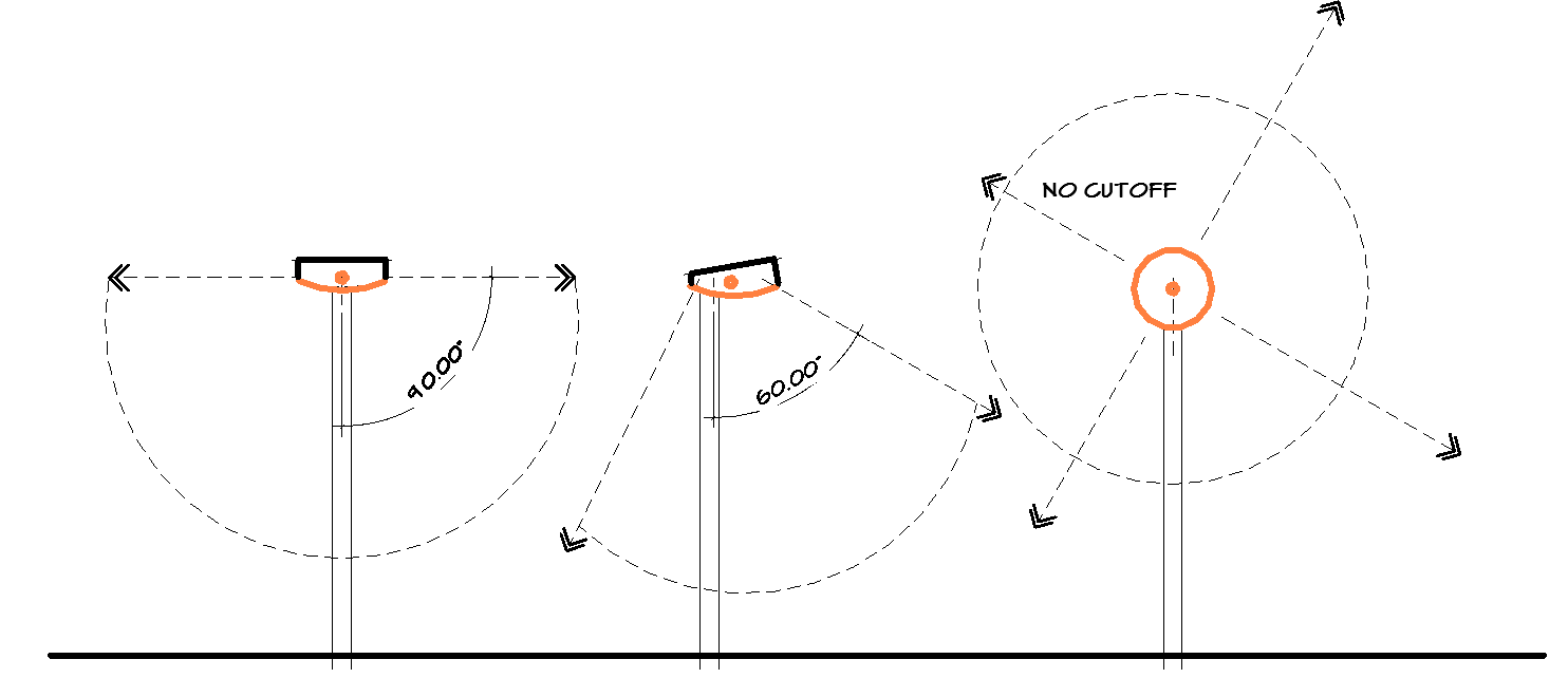
Full cutoff fixtures qualify with a cutoff angle to or less than 90-degress with no light projecting skyward.
e) Fixture Height.
1) The fixture height in the parking lots shall not exceed twenty (20) feet.
2) Lighting located under canopies shall be flush mounted or recessed within the canopy.
3) Fixture height shall be measured from the finished grade to the topmost point of the fixture.
f) Kelvin Temperature. The color temperature for all lights shall not exceed 4,000K.
g) Exterior lighting shall be designed and located to have the following maximum illumination levels. The levels shall be measured at the finished grade at the Lot Line as demonstrated by a lighting plan:
1) The maximum illumination at a Lot Line that abuts a lot within an existing Residential District or is zoned or designated for residential uses shall be 0.3 foot-candles;
2) The maximum illumination at a Lot Line that abuts any other use shall be one (1)-foot candles;
3) The maximum illumination at a Lot Line for properties used for outdoor sports and recreation shall be reviewed for compliance regarding the intent of these guidelines to minimize the impact of light trespass and glare on all surrounding properties and public rights-of-way; and
4) The illumination across any property shall be designed to not create excessive dark spots that may create safety issues.
h) Automobile Oriented Uses – Canopy Lighting. Automobile Oriented Use canopy lighting must be recessed within the canopy and use an opaque shield around the sides of the light.
17.15 PORTABLE HOME STORAGE UNITS
Portable Home Storage Units shall be a Permitted Use within the Farm Residential (FR) District and a Conditional Use in the Rural Residential (RR) and District, provided the following regulations are met. A Zoning Permit shall be obtained for any Portable Home Storage Unit.
a) Portable Home Storage Units shall be prohibited from being located within any right-of-way.
b) Portable Home Storage Units shall be kept in the driveway of the property at the furthest accessible point from the street.
c) Only two (2) Portable Home Storage Units shall be permitted on any residential property at any one time.
d) Portable Home Storage Units shall be permitted for thirty (30) consecutive calendar-days within any 365 calendar-day period.
e) The Zoning Inspector may grant a one-time extension of up to thirty (30) consecutive calendar days. Any additional extensions would require action by the Board of Zoning Appeals, which would be processed as a variance from these regulations.
f) Portable home storage units and roll-off containers shall not be utilized for living purposes.
17.16 PRIVATE SWIMMING POOLS
No Private Swimming Pool, except for Temporary Swimming Pools, shall be allowed in the specified Districts under Section 8.02 unless the following conditions and requirements are met. A Permit according to Section 3.06 shall be required for the construction or installation of any Private Swimming Pool. The owner of the property, or their agent, shall certify that the pool will be constructed, installed, and maintained in conformance with the requirements below:
a) It may not be located closer than fifteen (15) feet to any property line and may not encroach upon any required front yard, side yard, or any required on- site wastewater leaching areas;
b) Any inground swimming pool shall be walled or fenced to prevent uncontrolled access by children from any street or adjacent property. Any such fence shall not be less than four (4) feet in height and maintained in good condition with a gate and lock or automatic retractable load-bearing pool cover; and
c) Exterior lighting shall be shaded wherever necessary to avoid casting direct light upon any other property or any public street.
17.17 RECREATIONAL VEHICLES
Residents shall be permitted to park a Recreational Vehicle on a lot in any Residential District which permits one (1) or two (2) dwelling units, provided the following criteria are met:
On any Residential District Lot, generally:
Recreational Vehicles shall be parked on a paved or gravel surface located behind the primary structure and shall not be parked in the grass or on any other unpaved surface;
Recreational Vehicles shall be parked in compliance with the minimum setback requirements of the applicable Zoning District; and
Recreational Vehicles shall not be located forward of the front plane of the primary dwelling. However, the Recreational Vehicle may be parked on the paved driveway in front of the main dwelling for a period not to exceed forty-eight (48) hours for loading and unloading. In no case shall said Recreational Vehicle be parked, stored, or displayed for sale in a manner that blocks any sidewalk or obstructs sight lines for any vehicle entering or exiting the right-of-way.
On Lots less than three (3) acres:
a) There shall be a maximum of one (1) Recreational Vehicle per dwelling unit permitted on said lot. For the purposes of this Code, a boat stored on a boat trailer is considered one (1) Recreational Vehicle. Said Recreational Vehicle shall not exceed forty (40) feet in length, nine (9) feet in width, and twelve (12) feet in height.
17.18 SHORT-TERM RENTALS
a) Purpose. The purpose of this section is to adapt to new rental market trends that include online platforms, while also protecting residential neighborhoods from disruption that could result from Short-Term Rentals and to create a convenient, safe, and harmonious environment in which Short-Term Rentals can be permitted and consistent with neighborhood tranquility.
b) Applicability. Hosted Short-Term Rentals are considered Conditional Uses in any Residential District. Unhosted Short-Term Rentals shall be prohibited in any zoning district in Trenton Township.
c) Registration. An application for a Short-Term Rental permit, and/or renewal of a permit, shall be made to the Township, with an application fee listed in the separate Fee Schedule adopted by the Township.
d) Requirements . Prior to issuing a Conditional Use Permit, the Board of Zoning Appeals must determine that the specific criteria for Conditional Uses in Section 3.07 are met in addition to the following regulations:
1) Short-Term Rentals shall be wholly within the principal or accessory residential structure. The Accessory Structure shall be no larger than 1,000 square feet;
2) The principal or accessory residential structure, in which the Short-Term Rental is conducted, shall maintain the appearance of a Single-Family Dwelling Unit and be compatible with surrounding residences, in size and scale;
3) The Short-Term Rental establishment shall be operated by the occupant or owner of the premises, and must be a Hosted Short-Term Rental as defined in Article 18;
4) Exterior Signs shall be limited to a single nameplate not more than twelve (12) square feet in size. No Signs shall be internally illuminated;
5) Adequate Off-Street Parking shall be provided as determined by the Board of Zoning Appeals. Off-Street Parking shall not be allowed in the Front Yard;
6) There shall be a limit of one (1) Short-Term Rental per Dwelling Unit on a parcel; and
7) The Zoning Inspector may revoke the Conditional Use Permit if the property is delinquent in filing or payment of any County or Township tax.
e) Severability. If the Ohio Revised Code is amended to contradict with any portion of the standards in this section that are consistent with state law shall remain in full force and effect.
17.19 SOLAR ENERGY SYSTEMS
a) Establishment and Purpose. The purpose of this Article is to provide a regulatory framework for the installation and construction of solar energy systems (SES), subject to reasonable restrictions, which will preserve the public health, safety, and welfare, while also maintaining the character of the Township. This section applies to SES to be installed and constructed on any property in any Zoning District for systems generating up to fifty (50) MW per the Ohio Revised Code. Any SES producing more than fifty (50) MW is exempt from the requirements of this section and are subject to the jurisdiction of the Ohio Siting Board.
b) General Requirements
1) Integrated or Rooftop Solar Energy Systems:
i) Height: The maximum height of any Integrated or Rooftop Solar Energy System shall not exceed the maximum height applicable to principal structures located in the zoning district where located. An Integrated or Rooftop Solar Energy System mounted on a roof shall not vertically exceed the highest point of the roof to which it is attached or on a flat roof, an Integrated or Rooftop Solar Energy System is permitted to exceed the respective Zoning District height limit by up to five (5) feet.
2) Small Ground Mounted Solar Energy Systems:
i) Height: The maximum height of any Small Ground Mounted Solar Energy System at any point shall not exceed fifteen (15) feet.
ii) Coverage: Small Ground Mounted Solar Energy Systems shall be included as part of any lot/tract/ground coverage calculation applicable to the zoning district where located. In the event a zoning district does not have a restriction limiting the ground area occupied by buildings, structures, parking areas, sidewalks, or other impervious surfaces, all Ground Mounted Solar Energy System(s) shall not exceed in the aggregate twenty-five (25%) percent of the total area of the lot or tract.
iii) Visual Buffer: A Small Ground Mounted Solar Energy System shall have a visual buffer of natural vegetation, plantings, and/or fencing that provides reasonable visual screening to minimize view of and noise from the Small Solar Facilities on adjacent lots and from any public right-of-way. Small Ground Mounted Solar Energy Systems located on corner lots shall comply with the applicable requirements (including, but not limited to, those for yards, buffering, and screening) for lots in the zoning district where located.
3) Intermediate and Large Ground Mounted Solar Energy Systems: :
i) Height: The maximum height of any Intermediate or Large Ground Mounted SES at any point shall not exceed fifteen (15) feet.
ii) Coverage: All Intermediate and Large Ground Mounted SESs shall be included as part of any lot/tract/ground coverage calculation applicable to the zoning district where located. In the event a zoning district does not have a restriction limiting the ground area occupied by buildings, structures, parking areas, sidewalks, or other impervious surfaces, All Other Small Solar Facilities shall not exceed in the aggregate sixty-five percent (65%) of the total square footage of the lot or tract.
iii) Visual Buffer: All Intermediate and Large Ground Mounted SESs shall have a visual buffer of natural vegetation, plantings, and/or fencing that provides reasonable visual screening to reduce view of and noise from the Small Solar Facilities on adjacent lots and from any public right-of-way. All Other Small Solar Facilities located on corner lots shall comply with the applicable requirements (including, but not limited to, those for yards, buffering, and screening) for lots in the zoning district where located.
4) Lighting. Any lighting for a SES shall meet any lighting restrictions applicable to the zoning district where located. In the event there are no applicable provisions regarding lighting, all lighting in, of, and associated with the SES must narrowly focus light inward toward the solar equipment, be downlit and shielded, and result in a maximum horizontal illuminance level not to exceed one foot-candle. Small Solar Facilities shall be placed or arranged in a manner so as not to reflect unreasonable glare onto adjacent buildings, properties, or roadways.
5) Noise. Any SES shall comply with the noise resolution and all applicable noise restrictions set forth within the Township, including, but not limited to, those applicable to the zoning district where located. In the event there are no applicable provisions regarding noise, no SES Facility shall emit sound to an adjacent lot at a level exceeding sixty-five (65)decibels.
6) Setbacks: Setbacks for any SES shall be measured from the center of the road and must comply with the minimum Setback requirement for the applicable Zoning District with no exemptions available.
7) Maintenance: SESs must be maintained in good working order at all times. The owner of the property and owner of the SES shall, within thirty (30) days of permanently ceasing operation of a SES , provide written notice of abandonment to the Zoning Inspector. An unused SES may stand no longer than three (3) months following abandonment. All costs associated with the dismantling/demolition of the SES and associated equipment shall be borne by the property owner. A SES is considered abandoned when it ceases transmission of electricity for thirty (30) consecutive days. Removal includes removal of all apparatuses, supports, and or other hardware associated with the existing SES and, in the case of Ground Mounted Solar Energy Systems installed returning the property to a graded, seeded and/or landscaped state similar to its condition prior to the construction/installation.
8) Building Permits: All SES and parts thereof shall obtain all applicable required Building Permits from the State of Ohio and County or other local building jurisdiction.
9) Other Restrictions: A SES shall comply with all applicable federal, state, and local laws, rules, and regulations.
c) Criteria for Conditional Uses
1) A SES to be located in a zoning district in which it is identified as a conditional use is subject to and shall follow the application process for a Conditional Use Permit provided under this Zoning Resolution.
2) Where identified as a conditionally permitted use, any SES shall comply with the following specific requirements:
i) Road Use Maintenance Agreement: The property owner shall provide for the adequate maintenance and protection of Township maintained, protected, or managed infrastructure (including, but not limited to roadways, rights-of-way, and easements) to be used in connection with the SES as detailed further in a road use and maintenance agreement (“RUMA”) with the Township. Any damaged public roads, culverts, and bridges shall be repaired promptly to their previous or better condition by the property owner or their designee under the guidance of the appropriate regulatory authority.
ii) Safety Services: The property owner shall provide sufficient evidence that the property can be adequately served by the appropriate safety services, for example, a letter from the applicable fire department verifying that emergency response personnel and vehicles can safely reach and service the property, including the area where the SES is located.
iii) Location:
A) Any SES other than an Integrated or Rooftop Solar Energy System (except components located entirely underground) shall be located entirely in the rear yard.
B) No SES shall be located on the front façade of any structure or on any façade facing a public right-of-way.
C) No SES shall be located in front of a principal building or structure. In the case of corner lots, no SES shall be located between a principal building or structure and a public right-of-way.
iv) Height. the maximum height of any SES shall not exceed fifteen (15) feet.
v) Buffers and Setbacks:
A) Where a SES is located on property adjacent to or in close proximity to property zoned for residential use (as determined by the Zoning Inspector), no part of the SES (other than components located entirely underground) shall be located within fifty (50) ) feet of an existing residential dwelling.
B) No SES (other than components located entirely underground) shall be located within fifty (50) feet of another property line.
C) No SES (other than components located entirely underground) shall be located within twenty-five (25) feet of a public right-of-way or shared-use driveway.
vi) Visual Buffer: A SES shall have a visual buffer of natural vegetation, plantings, and/or fencing designed to and that does all of the following:
A) Enhances the view from any existing residential dwelling and from any public right-of-way;
B) Is in harmony with the existing vegetation and viewshed in the area; and
C) Provides reasonable visual screening to minimize view of and noise from the Small Solar Facilities to adjacent lots and from any public right-of-way.
vii) Glare: Solar panels shall be placed or arranged in a manner so as not to reflect unreasonable glare onto adjacent buildings, properties, or roadways.
viii) Lighting: All lights associated with the SES must narrowly focus light inward toward the equipment, be downlit and shielded, and prohibit any spillover onto any adjacent property.
ix) Fencing: Any fencing and/or screening installed in connection with the SES shall be harmonious and compatible with the surrounding properties and uses. Fencing shall be maintained in good repair and in an aesthetic manner at all times.
x) Conditions: Any conditions or other requirements as determined by the Board of Zoning Appeals in connection with the issuance of a Conditional Use Permit.
d) Zoning Permit.
1) A certificate of zoning compliance shall be required before any construction is commenced on a SES .
2) Applicant shall provide the Township Zoning Inspector with the following items and/or information when applying for a certificate of zoning compliance:
a) An engineering report that shows:
i) The total size and height of the proposed SES.
ii) Data specifying the megawatt size and generating capacity in megawatts of the particular SES .
iii) Hazardous materials containment and disposal plan.
b) A site drawing showing the location of the SES including all equipment and components thereof in relation to (and measurements of distances from) all existing structures on the property, roads and other public rights-of-way, and neighboring property lines.
c) Evidence of compliance with applicable setback and all other applicable zoning restrictions.
d) A maintenance schedule as well as a dismantling plan that outlines how the SES including all equipment and components thereof will be dismantled at the end of their use and/or upon abandonment.
e) Any other information or materials reasonably requested by the Zoning Inspector.
17.20 TELECOMMUNICATION TOWERS
Cellular towers may be allowed as a conditional use in residentially zoned areas, provided all applicable regulations are satisfied and the following conditions are met:
a) The maximum height of the tower shall not exceed 150 feet;
b) The tower shall not be placed closer than 180 feet from any residential dwelling and be setback 150 feet from any lot line;
c) The minimum lot size for a lot on which a tower is to be placed shall be two (2) acres;
d) Accessory buildings shall meet all requirements of the district in which it is to be located;
e) Security fencing shall be provided to prevent uncontrolled access to the tower site;
f) To the extent possible the tower shall be designed to aesthetically complement the surrounding community. Towers shall be painted in a non-contrasting color, minimizing visibility, unless otherwise required by the FCC or FAA;
g) A landscaping plan must be submitted and approved by the Board of Zoning Appeals. An evergreen hedge planted three (3) feet on center, or an evergreen tree line planted five (5) feet on center is suggested. All existing vegetation shall be retained and maintained to the extent possible;
h) The tower shall not be artificially lighted except to assure safety or as required by the FAA;
i) Towers must be designed and certified by an engineer to be structurally sound and, at a minimum, in conformance with the Ohio Basic Building Code;
j) The tower shall be fully automated and unattended on a daily basis, and shall be visited only for periodic and necessary maintenance;
k) The applicant or tower provider shall demonstrate that the cellular tower must be located where it is proposed to service the applicant’s service area and that there are no alternative sites reasonably available. This shall include an explanation and accompanying documentation as to why a tower on this proposed site is technically necessary;
l) Where the tower is located on a property with another principal use, the applicant shall present documentation that the owner of the property supports the application, and that vehicular access is provided to the property. Reasonable access and circulation shall be provided to the tower;
m) The applicant shall provide a signed statement indicating that the applicant agrees to allow for the potential co-location of other towers to the extent possible, the removal of the tower within 180 days after the site’s use is discontinued, and proof of notice has been provided as required in ORC Section 519.211; and
n) A tower may be attached to a residential or non-residential building or a structure that is a permitted use in the district, provided Sections 17.20(a)-(m), above, are met and the tower height does not exceed eight (8) feet above the existing building or structure to which the tower is attached.
17.21 TEMPORARY STRUCTURES
a) Temporary Construction Trailers/Offices.
1) Temporary Trailers/Offices may be permitted in any District during the construction of building(s) and site improvements provided the following regulations are met. A Zoning Permit shall be obtained prior to installing and utilizing the temporary construction trailer/office.
2) The Temporary Trailer/Office shall be prohibited from being located in the right-of-way and shall have a minimum setback of ten (10) feet from the right-of-way line.
3) In all Districts, except Residential Districts, the Temporary Trailer/Office shall only be permitted for a period of two (2) years. If additional time is necessary due to a delay in construction, the applicant shall seek an extension from the Zoning Inspector.
b) Temporary Structures for Residential Uses
1) Temporary Structures for single lots with residential uses shall be prohibited from being located in the right-of-way and shall have a minimum setback that matches the setbacks of the respective district.
2) Temporary Structures for single lots with residential uses must be removed upon completion of the residential use.
3) Temporary Structures for residential uses within a subdivision shall be removed within two (2) years from the start of the phase of residential subdivision.
17.22 VISIBILITY AT INTERSECTIONS
a) Sight Triangle. There shall be a sight triangle established at every intersection of two public Rights-of-Way. The sight triangle is the triangular area where two (2) streets intersect, bounded by the edge of the street and a line joining the points on the Rights-of-Way from their point of intersection for a distance equal to half the width of each street Right-of-Way. The vision triangle shall be measured along the Right-of-Way within the boundaries of the property.
b) Visibility Maintained. There shall be no visual obstructions within the defined sight triangle. A visual obstruction is any object between the height of no more than three (3) feet measured relative to the elevation to the nearest pavement crown. This is based on a driver eye height of three feet (based on the American Association of State Highway and Transportation Official standards). Overhanging branches or other elevated obstructions shall not be any lower than ten (10) feet measured relative to the elevation of the nearest pavement crown.
c) Non-Signalized, Arterial and Collector Road Intersection Sight Distances. In order to properly calculate the intersection sight distance for cars turning left and right onto non-signalized Arterial or Collector Roads, look to the equation and table provided in Section 201.3.2 of the ODOT Location & Design Manual, Volume 1 – Roadway Design. These standards for sight distances shall additionally be met during the application procedures found for Delaware County Subdivision Regulations, where applicable.
d) Example where Right-of-Way = Lot Line
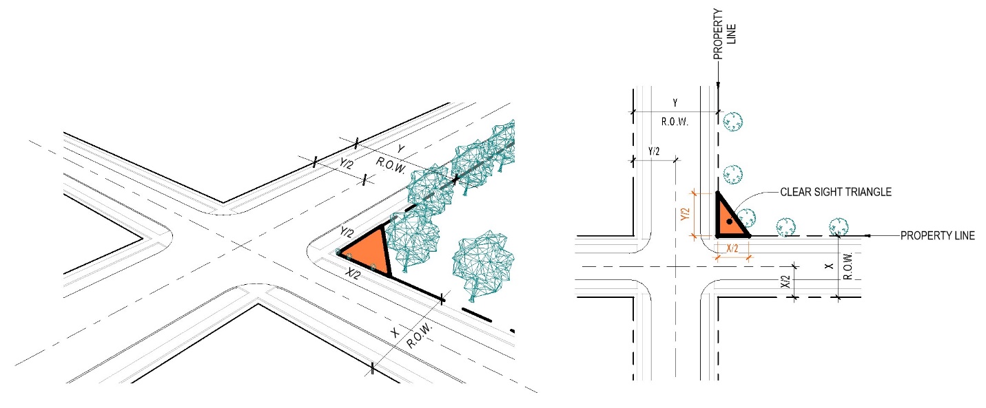
e) Example where Lot Line is the Centerline of the Road:
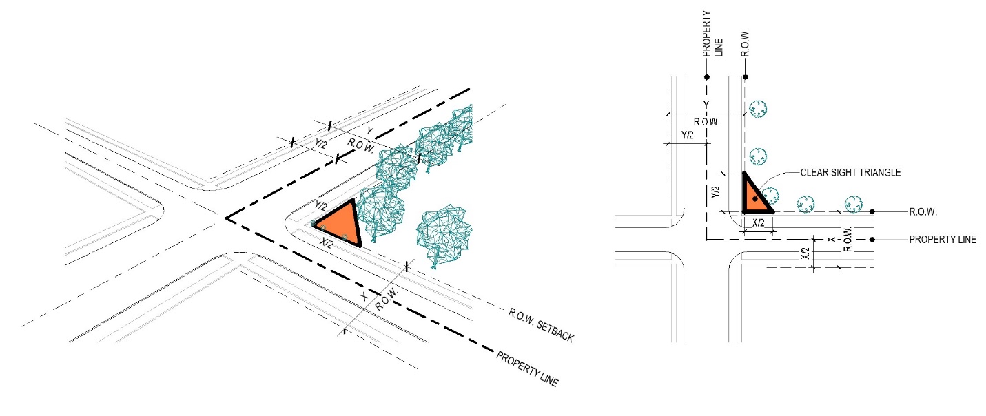
17.23 WIND ENERGY SYSTEMS
a) Intent. The intent of this section is to regulate the placement and construction of Individual Wind Energy Systems, as defined in Article 18, to protect the health and safety of Township residents without interfering with the expansion of clean, sustainable, and renewable energy sources.
b) Applicability.
1) The following regulations shall apply to Individual Wind Energy Conversion Systems when proposed to be located within a Zoning District where such use is listed as a Conditional Use, unless otherwise exempted by state or federal law.
2) Individual Wind Energy Conversion Systems shall be considered a Conditional Use in FR and RR Districts.
c) Conditions. The Board of Zoning Appeals shall issue a Conditional Use permit when a proposed Individual Wind Energy System complies with all of the conditions listed below.
1) In no case shall any tower within an Individual Wind Energy System be located closer than two (2) times the tower height to any residential Structure, public road/right-of-way, third party transmission lines, or adjacent property lines. New residential structures shall not be permitted within this Setback area.
2) No individual wind tower shall be taller than 150 feet;
3) Individual Wind Energy Systems shall conform to applicable industry standards, including those of the American National Standards Institute (ANSI). Applicants shall submit certificates of design compliance that equipment manufacturers have obtained from Underwriters Laboratories (UL) or an equivalent third party.
4) Once a Conditional Use permit is granted per the requirements of this Section, a licensed Ohio professional engineer shall certify, as part of the Zoning Permit application, that the foundation and tower design of the Individual Wind Energy System, including substation, transformer, underground cabling, or parts thereof and the access road, is within the accepted professional standards, given local soil, and climate conditions.
5) All Individual Wind Energy System shall be equipped with a redundant braking system. This includes both aerodynamic over speed controls (including variable pitch, tip, and other similar systems and mechanical brakes). Mechanical brakes shall be operated in a fail–safe mode. Stall regulations shall not be considered a sufficient braking system for overspeed protection. The applicant shall provide sufficient information to assure the Board of Zoning Appeals that this requirement will be met.
6) All electrical components of the Individual Wind Energy System shall conform to applicable local, state, and national codes, and relevant national and international standards (ANSI).
7) Towers and blades shall be a non–contrasting gray or similar color or a galvanized steel finish unless these color requirements conflict with any FAA regulation. In such cases, the tower shall comply with those color requirements.
8) All towers within an Individual Wind Energy System are unclimbable by design or protected by anticlimbing devices.
9) No signage shall be permitted within any portion of an Individual Wind Energy System except for a Sign, not to exceed six (6) square feet;
10) One point of access from a public road to the Individual Wind Energy System shall be provided. The Board of Zoning Appeals may require review by the Township fire department to ensure the proposed drive is suitable for emergency access. The use of existing access points is preferred.
11) The applicant shall be responsible for obtaining all required approvals/permits for transporting on a public road the towers, blades, substation parts, and or equipment for construction, operation, or maintenance of the Individual Wind Energy System.
12) The applicant shall demonstrate that the noise levels associated with the Individual Wind Energy System will not be disruptive to any adjacent residential areas.
13) No lighting shall be permitted, except as required by Federal regulations.
14) The applicant shall provide the applicable microwave transmission providers and local emergency service providers/911 operators copies of the project summary and site plan as set for in this Section. To the extent that the above providers demonstrate a likelihood of interference with its communications resulting from the Individual Wind Energy System, the applicant shall take reasonable measures to mitigate such anticipated interference. If, after construction of the Individual Wind Energy System, the Owner or operator receives a written complaint related to the above–mentioned interference, the Owner shall take reasonable steps to respond to the complaint or shall be in violation of said Conditional Use permit, which shall be punishable per Article 5.
15) The Owner or operator of the Individual Wind Energy System shall be required to submit an annual notice of operation on or before January 31st of each year. In the event that the Individual Wind Energy System is no longer being operated or utilized (unless due to documented maintenance or electrical grid issues and written notice has been provided to the township), the Individual Wind Energy System shall be removed within 180–days after the Use has been discontinued. In addition to removing all towers within the system, the Owner/operator shall restore the site to its original condition prior to the location of such system on said property. Any foundation associated with an Individual Wind Energy System shall be removed from the site to a depth which is at least forty–eight (48) inches below restored ground level, and the site restored to its original state including the planting of any grasses or cover crops. All transmission equipment, Buildings and fences shall also be removed.
d) Submittal Requirements. The following information must be submitted with the Conditional Use application (in addition to the items required in Section 3.06).
1) An Individual Wind Energy System project summary including to the extent available the following items:
i. A general description of the project, including its approximate name plate generating capacity; the potential equipment manufacturer(s) type(s) of the Individual Wind Energy System, the number of towers within the proposed Individual Wind Energy System, and the name plat generating capacity of each tower, and the maximum height proposed for each tower.
ii. A description of the Applicant, Owner, and/or Operator, including their respective Business Structures.
2) The name(s), address(es), and phone number(s) of the applicant(s), Owner and operator, and all property Owner(s), if known.
3) The site plan required in Section 11.22(d)(1), above, shall also include: guy lines and anchor bases (if any), primary Structure(s), property lines (including identification of adjoining properties), setback lines, public access roads and turnout locations, substation(s), ancillary equipment, third party transmission lines, and layout of all Structures within the geographical boundaries of any Setback.
4) All required studies, reports, certifications, and approval demonstrating compliance with the provisions of this Zoning Resolution.
ARTICLE 18 – DEFINITIONS
18.01 INTERPRETATION
For this Zoning Code, certain terms and words are to be defined as found in this Article. Words and terms not specifically defined carry their customarily understood meanings. Words and terms not specifically defined carry their customarily understood meanings. Words used in the present tense include the future tense. The singular form shall include plural, and plural shall include singular. The word “shall” is intended to be mandatory. “Occupied” or “used” shall be considered as though followed by the words “or intended, arranged, or designed to be used or occupied.”
Terms related to specific Articles or sections may be defined within the specific portions of the Zoning Code where these general requirements are found.
18.02 DEFINITIONS
ACCESS POINT – The connecting area of a lot where a vehicle gains egress and ingress from a driveway to a public roadway.
ACCESSORY DWELLING UNIT (ADU) – A smaller, secondary Dwelling Unit on the same lot or within a primary Dwelling Unit. An ADU is an independent Dwelling Unit that provides for the basic requirements of shelter, heating, cooking, and sanitation.
ADU, ACCESSORY SUITE – An ADU that is adjacent and connected to or located completely within the primary dwelling unit, including, but not limited to, the basement, attic, attached garages, attached by a breezeway, or an addition to the primary structure.
ADU, DETACHED – An ADU located in a structure that is detached from the primary dwelling unit, including, but not limited to, a detached garage or a newly constructed structure.
FIGURE 18(a) – Accessory Dwelling Units
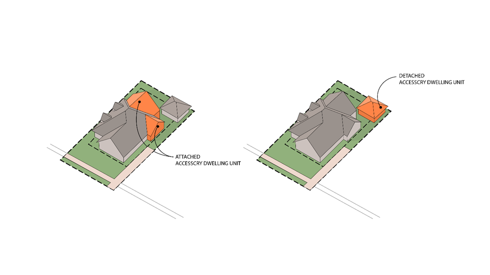
ACCESSORY STRUCTURE, OR USE – A use or structure subordinate to the principal use of a building on the lot or tract and serving a purpose customarily incidental to the use of the principal building. Accessory structures are located on the same lot as the primary structure and are not designed for human occupancy as a dwelling or commercial use. Examples of accessory structures are detached private garages, storage or garden sheds, pool houses, metal storage buildings, hot tubs, and other similar type buildings. This definition does not include gardens, patios, uncovered porches, and decks that are less than three-and-one-half (3.5) feet above the average finished Grade. Private swimming pools are regulated by Section 17.16.
ACCESS ROAD – A minor Street parallel to a thoroughfare to afford abutting property owners access to the thoroughfare at limited points.
ACRE, GROSS – The total acreage of a property or parcel.
ACRE, NET – The total acreage of a property or parcel minus any wetlands, water bodies, public parks, open spaces, roads, or other public rights-of-way.
ADULT BOOKSTORE – A commercial establishment where at least fifty-one percent (51%) of its interior floor area or retail merchandise is devoted to the sale, rent, lease, inspection, or viewing of books, films, video cassettes, DVDs, magazines, other periodicals or digital presentations whose dominant theme is the actual or simulated Specified Sexual Activities, display, or exhibition of specified anatomical areas, removal of articles of clothing, or total nudity.
ADULT CABARET – A restaurant, coffee house, bar, or cabaret that features dancers, strippers, impersonators, or similar entertainers who provide live adult entertainment for commercial purposes.
ADULT ENTERTAINMENT BUSINESS – Any adult bookstore, adult cabaret, or adult motion picture theater.
ADULT ENTERTAINMENT – Any motion picture, live performance, display, or dance of any type whose dominant theme is actual or simulated Specified Sexual Activities, display or exhibition of anatomical areas, removal of articles of clothing, or total nudity offered for commercial purposes.
ADULT MOTION PICTURE THEATER – A movie theater used for displaying adult entertainment through films, video, or other motion pictures for commercial purposes.
ADVANCED MANUFACTURING – A use that involves computer technology, robotics, or other innovation to improve a product or process.
AGRICULTURE – Means the same as stated in Section 519.01 of the Ohio Revised Code, as may be amended, to include farming; ranching; aquaculture; apiculture; horticulture; viticulture; animal husbandry, including, but not limited to, the care and raising of livestock, equine and fur-bearing animals; poultry husbandry and the production of poultry and poultry products; dairy production; the production of field crops; tobacco; fruits; vegetables; nursery stock; ornamental shrubs; ornamental trees; flowers; sod or mushrooms; timber; pasturage; any combination of the foregoing; the processing, drying, storage, and marketing of agricultural products when those activities are conducted in conjunction with, but are secondary to, such husbandry or production.
AGRICULTURAL BUILDING – A structure on agricultural land designed, constructed, and used to house farm implements, livestock, or agricultural produce or products used by the owner, lessee, or sub-lessee or their immediate families, their employees, and persons engaged in the pick-up or delivery of agricultural produce or products grown or raised on the premises.
AGRICULTURAL ENTERTAINMENT (AGRITOURISM) – An enterprise at a working farm, ranch, or agricultural plant conducted for the enjoyment of visitors that generates income for the owner. Agritourism refers to the act of visiting a working farm or any agricultural operation for the purpose of enjoyment, education, or active involvement in the activities of the farm or operation that also adds to the economic viability of the site. Agritourism may include country-themed stores for the sale of goods and souvenirs, dining, tours (self-guided or guided), wagon rides, trail rides, corn mazes, pick yourself operations, classes (gardening, cooking, crafts, etc.), fishing, bed, and breakfast, in addition to guests partaking in other farm activities.
AGRICULTURAL RELATED BUSINESS – Feed mills, dairy supplies, poultry processing, creameries, auction yards (for livestock, farm implements, and other farm-related goods; this does not include commercial auction yards for automobiles, furniture, antiques, and other non-agricultural goods), veterinarians, and other businesses supporting local Agriculture.
AIRPORT – Includes any complex of runways and buildings for the takeoff, landing, and maintenance of civil aircraft that is approved and/or properly licensed by the Federal Aviation Authority or applicable agency.
ALLEY – A secondary access way that is a public right-of-way dedicated to public use for travel or transportation and affording vehicular access to abutting property.
ALTERATION – Any change or rearrangement in the supporting members of an existing structure; enlargement, addition, relocation, repair, remodeling; change in the number of living units; development of or change in an open area; development of or change in a sign, by painting or otherwise; or other change in a facility, but excluding painting except as provided above for signs; ordinary maintenance for which no building permit is required; and demolition or removal.
ANIMAL SERVICE FACILITY – A facility devoted to the medical care and treatment of small animals, including household pets, but does not allow for the overnight stay of animals and pets unless deemed necessary by a licensed veterinarian. Animal care facilities may also include animal grooming establishments.
APPEAL – A request by an aggrieved party for a review of any adverse decision by the Zoning Inspector or Zoning Commission.
ARCHEOLOGY – The scientific study of material remains (such as tools, pottery, jewelry, stone walls, and monuments) of past human life and activities.
AREA OF SPECIAL FLOOD HAZARD – The land in the Flood plain adopted by the Trenton Township, including that identified by the Federal Emergency Management Agency (FEMA), which is subject to a one percent (1%) or greater chance of Flooding in any given year.
ASSISTED LIVING FACILITY – A residential facility designed to meet housing and care needs of older persons and individuals with disabilities in a residential rather than institutional environment, while maximizing independence, choice, and privacy. Assisted living programs provide personal care for persons with needs for assistance in the activities of daily living and can respond to unscheduled needs for assistance. Services typically provided include meals, housekeeping, laundry and linen service, medication monitoring, transportation, and activities. Assisted living settings also typically provide features that enhance resident autonomy, such as lockable doors, full bathrooms, temperature control, and single occupancy, and may provide limited cooking facilities in individual units. Assisted Living Centers exclude nursing homes and other special housing facilities as elsewhere defined.
AUTOMOBILE-ORIENTED USE – A use that includes services rendered directly on, to, or for vehicles or where the patron does not exit the vehicle. Such uses include but are not limited to car washes (all types), gas stations (including convenience market), Automobile Oil Changing Facilities, Automobile Oil Changing Facilities, and other similar auto service facilities. The sale of vehicles (new and used) is not included in this definition. Any facility that provides a fixed parcel pick-up location is not included within this definition. It also does not include Drive-Thrus or Pick-Up Banking Windows.
AUTOMOBILE OIL CHANGING FACILITY – A facility where oil is removed from a vehicle and new oil is placed into the vehicle without any repair services being provided to the vehicle.
AUTOMOBILE REPAIR – Any building or portion of a building used for the servicing and minor repair of automobiles, including, but not limited to, the installation of exhaust systems, repair of the electrical system, transmission repair, brake repair, radiator repair, and tire repair.
AVERAGE DAILY TRAFFIC, OR “ADT” – The average number of motor vehicles per day that pass over a given point in a street or thoroughfare.
AWNING – A hood or cover that projects from the wall of a building and which can be retracted, folded, or collapsed against the face of the supporting building.
AQUIFER – An underground area with a large concentration of groundwater. Most often, Aquifers are found in underground areas of porous rock or sand. Many rural well systems draw from Aquifers. For planning purposes, an Aquifer is often evaluated on its recharging rate and cleanliness.
BANK – A financial institution licensed to receive deposits and make loans. Such use may also include financial services including, but not limited to, wealth management, currency exchange, and safe deposit boxes.
BASE FLOOD – A Flood having a one percent (1%) chance of being equaled or exceeded in any given year. The Base Flood may also be referred to as the 100-year Flood.
BASEMENT – The portion of a building where the floor is not less than two (2) feet below and the ceiling is not more than four-and-a-half (4.5) feet, above the average Grade.
BED AND BREAKFAST – A residential use consisting of one dwelling unit with no more than eight (8) rooms or suites that are rented to the public for overnight or weekly accommodation for a fee. Only the breakfast meal may be prepared for the guests by the proprietor and no other meals are provided by the proprietor. The rented rooms do not contain cooking facilities and do not constitute separate dwelling units.
BEVERAGE SALES, ALCOHOLIC – A facility that is primarily devoted to the serving of alcoholic beverages. Food can be served but is incidental to the sale of beverages. Also known as a bar, pub, or tavern.
BEVERAGE PRODUCTION, LARGE – A facility focused on the large-scale production of beer, cider, and/or spirits, brewing or distilling and primarily selling for regional distribution. Also known as a brewery.
BEVERAGE PRODUCTION, SMALL – A facility focused on the production of beer, cider, and/or spirits, brewing, distilling, or producing specialty beers or spirits and primarily selling them on-site or for local distribution. The facility may also offer food. Also known as a microbrewery.
BIO-TECHNOLOGY FACILITY – A facility designed to manipulate living organisms or their components to produce useful, common commercial products such as, but not limited to, pest resistant crops, new bacterial strains, and novel pharmaceuticals. This type of use is typically fully enclosed by four solid walls and a roof.
BODY ART ESTABLISHMENT – A building or portion of a building in which a practitioner performs body piercing, tattooing, branding, or application of permanent cosmetics and typically considered a small business retail use.
BUILDING – A combination of materials to form a safe and stable construction adapted to permanent or continuous occupancy for public, institutional, residential, business, or industrial purposes.
BUILDING ENVELOPE – A term to describe the area of a lot that is demarcated within the Front, Side, and Rear Setback Lines.
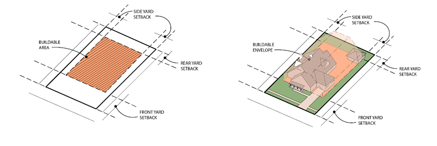
BUILDING LINE – A line parallel to the right-of-way line and at a distance there from equal to the required depth of the front setback (as determined by the applicable zoning district) and extending across the full width of the lot.
BURIAL – The act of placing a deceased human or animal or their remains in a final resting place such as a cemetery, mausoleum, or columbaria.
BUSINESS – Any profit-making activity which renders services primarily to other commercial, institutional, or industrial enterprises, or which services and repairs appliances and machines used in other businesses.
BUSINESS, RETAIL – A use primarily engaged in the selling of merchandise including, but not limited to, clothes, food, furniture, guns, household goods, gifts, specialty items, and other similar goods, and the rendering of services that are incidental to the sale of the goods.
BUSINESS, LARGE-RETAIL – A Retail or Wholesale Business that is twenty thousand (20,000) square feet or larger in area.
BUSINESS, MEDIUM-RETAIL – A Retail or Wholesale Business that is five thousand (5,000) square feet up to twenty thousand (20,000) square feet in area.
BUSINESS, SMALL-RETAIL – A Retail or Wholesale Business that is less than five thousand (5,000) square feet in area and typically services nearby neighborhoods.
BUSINESS, WHOLESALE – A use that generally sells commodities in large quantities or by single items to the general public, business members, retailers, or other wholesale establishments.
CANNABIS STORES, MEDICAL – A business that is licensed under the state laws of Ohio to sell cannabis and marijuana products for medical purposes.
CANNABIS STORES, RECREATIONAL – A business that is licensed under the state laws of Ohio to sell cannabis and marijuana products for recreational purposes.
CAMPGROUND – Any tract of land upon which two or more portable camping units are placed and includes any roadway, building, structure, vehicle, or enclosure used or intended for use as a part of the facilities of such camp. A tract of land that is subdivided for lease or other contract of the individual lots is a campground if two or more portable camping units are placed thereon for temporary inhabitation. “Campground” does not include any tract of land used solely for the storage or display for the sale of portable camping units.
CEMETERY – Land used for or intended to be used for the outside burial of human or animal remains and dedicated for said cemetery purposes, including columbaria, mausoleums, and funeral service facilities if operated in connection with and within the boundaries of the cemetery.
CERTIFICATE OF ZONING COMPLIANCE – A certificate issued by the Zoning Inspector confirming that the requirements of this Code have been met, and the building can be occupied.
CO-LOCATION – The use of a telecommunication tower by more than one (1) telecommunications provider.
COLUMBARIUM – A building, or part thereof, used as a holding place for cremated remains.
COMMENCEMENT OF WORK – The time at which physical improvements begin to be made to a property or structure so that it may be utilized for its intended purpose stated in the zoning permit.
COMMERCIAL RECREATIONAL FACILITY, LARGE – A facility that is full enclosed by four solid walls and a roof for the provision of athletic and amusement facilities involving the active participation of the user in a sport -related activity and includes but is not limited to racquet courts, billiards, bowling alleys, ax throwing, miniature golf courses and arcades. Large Commercial Recreational Facilities are greater than 5,000 square feet.
COMMERCIAL RECREATIONAL FACILITY, OUTDOOR – A facility that is not fully enclosed by four solid walls for the provision of athletic and amusement facilities involving the active participation of the user in a sports-related activity and includes but is not limited to fields for soccer fields, football, baseball, lacrosse or other related sports, racquet courts, billiards, bowling alleys, ax throwing, miniature golf courses and arcades.
COMMERCIAL RECREATIONAL FACILITY, SMALL – A facility that is fully enclosed by four solid walls and a roof for the provision of athletic and amusement facilities involving the active participation of the user in a sport -related activity and includes but is not limited to racquet courts, billiards, bowling alleys, ax throwing, miniature golf courses and arcades. Small Commercial Recreational Facilities are smaller than 5,000 square feet.
COMMON ACCESS DRIVE (CAD) – Privately constructed, owned and maintained drive within a platted ingress/egress easement, properly shown on a subdivision plat approved by the Delaware County Regional Planning Commission.
COMMUNICATION FACILITIES – A lot or an area of a lot that includes a telecommunication tower, radio tower, or other similar communication tools, including any associated appurtenances.
COMMUNITY SERVICES – Institutional uses that include but are not limited to community centers, museums, galleries, libraries, and other similar facilities.
CONDOMINIUM – A building in which each individual unit is held in separate private ownership, and all floor space, facilities, and outdoor areas used in common by all tenants are owned, administered, and maintained by a corporation created under the provisions of the appropriate statute.
CONDITIONAL USE(S) – A desirable use within a Zoning District that may more intensely affect the surrounding area than would a permitted use in said District. Such uses may require supplementary conditions and safeguards to ensure they blend with the surrounding area.
CONNECTIVITY – The idea of connections or throughways between examples of the same use, such as connecting parks, trails, landscaping buffers, etc.
CONTRACTOR OFFICE – A facility or area for the storage of materials, equipment, and commercial vehicles utilized by building and construction contractors, craftsmen, and tradesmen, and may include accessory offices related to such activities.
COUNTY – Delaware County, Ohio.
COUNTY ENGINEER – The Professional Engineer who is employed by the County and authorized by the County to act within the specifications of this Code.
CREMATORIUM – A building (or part thereof) used for cremating human remains.
DATA PROCESSING CENTER – A facility that houses computer systems and associated data and is focused on the mass storage of data.
DAY-CARE CENTER – Any place in which child day care or publicly funded child day care is provided for thirteen (13) or more children at one time or any place that is not the permanent residence of the licensee or administrator. In counting children for purposes of this Code, any children under six (6) years of age who are related to a licensee, administrator, or employee and who are on the premises of the center shall be counted.
DAY-CARE HOME, FAMILY LARGE – A permanent residence of the administrator in which childcare or publicly funded childcare is provided for seven (7) to twelve (12) children at one time or a permanent residence of the administrator in which childcare is provided for four (4) to twelve (12) children at one time if four (4) or more children at one time are under two (2) years of age. In counting children for the purposes of this division, any children under six (6) years of age who are related to a licensee, administrator, or employee and who are on the premises of the Type A home shall be counted. “Type A Family Day-Care Home” and “Type A home” do not include any child day camp (ORC Section 5103.01(RR)). This definition does not include a residence in which the needs of children are administered to if all the children whose needs are being administered to are siblings of the same immediate family and the residence is the home of the siblings. This definition shall not be construed to include child day camps.
DAY-CARE HOME, FAMILY SMALL – A permanent residence of the provider in which childcare is provided for one (1) to six (6) children at one time and in which no more than three (3) children under two (2) years of age at one time. In counting children for the purposes of this division, any children under six (6) years of age who are related to the provider and who are on the premises of the Type B home shall be counted. “Type B Family Day-Care Home” and “Type B home” do not include any child day camp (ORC Section 5103.01(SS)). This definition does not include a residence in which the needs of children are administered to if all the children whose needs are being administered to are siblings of the same immediate family and the residence is home of the siblings. This definition shall not be construed to include child day camps.
DEATH CARE – The industry of caring for human and animal deceased through funeral services, burial, and their associated land uses.
DENSITY, GROSS – The number of dwelling units permitted to be developed on a gross acre of land.
DENSITY, NET – The number of dwelling units permitted to be developed on a net acre of land.
DEVELOPMENT – Any human-made change to improved or unimproved real estate, including, but not limited to, buildings or other structures, mining, dredging, filling, grading, paving excavations, drilling operations, or storage of equipment or materials located within the area of special Flood hazard.
DRIVEWAY (ACCESS POINT) – A private drive giving access from a public way to a detached single-family dwelling on abutting ground or to a group of multifamily, commercial, or industrial Buildings, which is not dedicated to the Township and for the maintenance of which the Township shall not be responsible.
DRIVE-THRU – A use where a patron places an order on site or in advance and waits for a product to be prepared without the need to exit their vehicle. Such uses include but are not limited to drive-through or drive-in restaurants with ordering areas, drive-in movie theaters. A drive-through facility does not include any vehicle repair facility, gas station, fixed parcel pick up, and pick up-banking window.
DRIVEWAY THROAT/DRIVEWAY THROAT LENGTH – The distance along a driveway needed to transition vehicles to and from the internal circulation system of the site while preventing backup onto the public roadway. Measured from the edge of the road Right-of-Way to the end of the driveway within the land development wherein the driveway intersects any internal drive lines, parking stalls, or other internal connections. There are no connections within this area, which is preserved for the storage of vehicles entering and exiting the site to prevent the backup of traffic onto the public road. This allows the vehicles during the anticipated peak hour trip generator to clear the road and have adequate storage while vehicles ahead of them make maneuvers into parking stalls, internal drive lanes, or other internal connections.
DRUG REHABILITATION CENTERS – The collection of facilities that require Conditional Use Permits by the Township and are categorized as follows: Large Residential Facilities; Emergency and Protective Shelters; Transitional Living Centers; and Permanent Supportive Housing, as defined herein.
DWELLING, DUPLEX – A building designed for two dwelling units where each dwelling shares one common wall and the remaining sides of the building are surrounded by open areas or street lines.
DWELLING, MULTI-UNIT – A building designed or used primarily as a residence with four (4) or more dwellings units.
DWELLING, ONE-UNIT – A building designed exclusively for one detached Dwelling Unit that is situated on a parcel with no other principal structures and having a Front, Side, and Rear Yard.
DWELLING, TRI-PLEX – A building containing three (3) dwelling units, designed for occupancy by not more than three (3) families.
DWELLING UNIT – Any room or group of rooms located within a structure and forming a single habitable unit with facilities which are used, or are intended to be used, for living, sleeping, cooking, and eating, which is designed or used for residential purposes. This definition does not include a cabin, hotel, or motel.
DWELLING UNIT, ACCESSORY – See, Accessory Dwelling Unit.
DWELLING UNIT, ONE BEDROOM UNIT – A Dwelling Unit that is contained within a Multi-Unit Dwelling or Mixed-Use Building, as defined herein that contains only one (1) bedroom.
DWELLING UNIT, STUDIO – A Dwelling Unit that is contained within a Multi-Unit Dwelling or Mixed-Use Building, as defined herein that combines several different types of rooms, such as living room, bedroom, and kitchen, into a single room.
DWELLING UNIT, THREE OR MORE BEDROOM UNIT – A Dwelling Unit that is contained within a Multi-Unit Dwelling or Mixed-Use Building, as defined herein that contains three (3) bedrooms.
DWELLING UNIT, TWO BEDROOM UNIT – A Dwelling Unit that is contained within a Multi-Unit Dwelling or Mixed-Use Building, as defined herein that contains two (2) bedrooms.
EARLY CHILDHOOD LEARNING CENTER – An education establishment that provides learning space to children prior to beginning their compulsory education. This facility may also provide for the extended care of infants and young children.
ELDERLY/RETIREMENT HOUSING – A residential complex containing multifamily dwellings designed for and principally occupied by senior citizens. Such facilities may include a congregate meals program in a common dining area but exclude institutional care such as medical or nursing care and are distinguished from life care retirement centers as elsewhere defined.
EMERGENCY AND PROTECTIVE SHELTER – A facility which provides room and board for the protection, counseling, and pre-placement screening for abused, displaced, or transient children or adults.
ENCROACHMENT – The intrusion on another person’s property or public right-of-way, intentional or unintentional.
EQUIPMENT REPAIR, LARGE – A facility that is fully enclosed by four solid walls and a roof that is used for the repair of contactor’s equipment, heavy machinery, repair equipment, motor vehicles or trucks.
EQUIPMENT REPAIR, SMALL – A facility that is fully enclosed by four solid walls and a roof that is used to repair small tools and equipment such as lawn mowers, small tractors, and other small equipment.
FAÇADE – The face of a building, especially the principal front that looks onto a street or open space.
FAIR MARKET VALUE – The price a property owner could sell their property for under current market conditions.
FARM MARKET – Markets from which fifty percent (50%) or more of the gross income received is derived from produce raised or grown upon farms owned or operated by the market operation in a normal crop year.
FEDERAL EMERGENCY MANAGEMENT AGENCY (FEMA) – The federal agency with the overall responsibility for administering the National Flood Insurance Program.
FENCE – Any structure composed of wood, metal, stone, plastic or other natural or permanent material erected in such a manner and positioned as to enclose or partially enclose any portion of a lot.
FENCE, ACCENT – A fence that is used solely for ornamental purpose and does not enclose or partially enclose an area.
FENCE, BUFFER – A solid Fence that is used to demarcate space as applicable under Section 17.12 between a more dense Use, such as a commercial or industrial use, and a less dense use, such as agricultural or rural residential uses.
FENCE, BRICK or STONE WALL – A Privacy or Solid Fence constructed of stone or brick.
FENCE, CHAIN LINK – A fence usually made of metal, with loops of wire interconnected in a series of joined links. Chain Link Fences include vinyl, plastic-coated, and painted varieties.
FENCE, OPEN – A fence constructed for its functional, ornamental, or decorative effect and, when viewed at right angles, has at least fifty percent (50%) of its vertical surface area open to light and air.
FENCE, PERIMETER – A Fence erected as a continuous barrier that defines the boundary of a Tract of developed land.
FENCE, PICKET – A partially open fence made of upright poles or slats where the space between the poles/slats is greater than the width of the poles/slats.
FENCE, PRIVACY – Any fence that is designed to inhibit public view and provide seclusion, when viewed at right angles, and having more than fifty percent (50%) of its vertical surface area closed to light and air. Also known as a Solid Fence.
FENCE, WROUGHT IRON – A fence constructed of metal, including aluminum, iron or steel, pipe, tubes, or bar stock and having some type of decorative features or design. Wrought iron fences shall not have pointed ends exposed but may have finials with blunt ends.
FIRE DEPARTMENT – Refers to the Trenton Township Fire Department.
FIRE LANE – Locations determined by the Fire Department; shall be a minimum of twenty-five (25) feet in width; and shall be properly signed and striped.
FITNESS CENTER – A facility where members or nonmembers use equipment or space for the purpose of physical exercise.
FLEA MARKET – An outdoor commercial activity, not including shopping centers, individual retail operations, or sales conducted by a non-profit or charitable organization, which is open to the public and composed of five or more semi-enclosed or outdoor stalls, rooms, stands, or spaces used for the purpose of display and sale, exchange, or barter of merchandise.
FLEX OFFICE, LABORATORIES – A space for a combination of office and laboratory uses that has built out capabilities to meet individual needs.
FLEX OFFICE, RETAIL – A space with store fronts with small rear warehousing that has built out capabilities to meet individual needs.
FLEX OFFICE, WAREHOUSES – A space for a combination of office and warehouse uses that has built out capabilities to meet individual needs.
FLOOD OR FLOODING – A general and temporary condition of partial or complete inundation of normally dry land areas from:
a) The overflow of inland waters; and/or
b) The unusual and rapid accumulation or runoff of surface water from any source.
FLOODWAY FRINGE – The portion of the regulatory floodplain outside the floodway.
FLOOD INSURANCE RATE MAP (FIRM) – An official map on which the Federal Emergency Management Agency has delineated both the areas of special Flood hazards and the risk premium zones applicable to the Choose an item.
FLOOD INSURANCE STUDY (FIS) – The official report provided by the Federal Emergency Management Agency that includes Flood profiles, Floodway boundaries, and the water surface elevation of the Base Flood.
FLOOD PROTECTION ELEVATION – The elevation not less than one-and one-half (1.5) feet above the Base Flood elevation to which uses regulated by the Special Flood Hazard Regulations are required to be elevated or flood proofed to compensate for the many unknown factors that could contribute to flood elevations greater than that calculated for a Base Flood. In areas where no Base Flood elevations exist from any authoritative source, the Flood Protection Elevation can be historical flood elevations, of Base Flood elevations determined and/or approved by the Floodplain Administrator.
FLOODPLAIN ENCROACHMENT – Any Floodplain development that could obstruct Flood flows, such as fill, a bridge, or other development.
FLOODWAY – The channel of a river or other watercourse and the adjacent land areas that have been reserved to pass the Base Flood discharge. A Floodway is typically determined through a hydraulic and hydrologic engineering analysis such that the cumulative increase in the water surface elevation of the Base Flood discharge is no more than a designated height. In no case shall the designated height be more than one foot at any point within the community. The Floodway is an extremely hazardous area and is usually characterized by any of the following: moderate to high velocity flood waters, high potential for debris and projectile impacts, and moderate to high erosion forces.
FLOOR AREA – The sum of the gross horizontal areas of one or several floors of a building, measured from the exterior faces of the exterior walls or from the centerline of common walls separating two buildings. Floor area for the purpose of these regulations will not include basement, elevator and stair bulkheads, attic space, terraces, breezeways, open porches, and uncovered steps.
FLOOR AREA, LIVABLE – The portion of floor area of a dwelling unit that is constructed, completed, and usable for living purposes with normal living facilities which includes sleeping, dining, cooking, entertainment, common space, areas for personal hygiene, or combination thereof. Unheated rooms, unfinished garages, basements, or rooms used exclusively for utilities or storage shall not be considered as livable floor area. In no case shall an area less than six (6) feet in height be considered livable floor area.
FOOD CART – A small, wheeled vehicle typically pushed by hand, bicycle or propelled in some similar muscular manner to move it from place to place to offer already prepared or prepackaged food or ice cream for sale to the public. Any vehicle that is capable of preparing food within it shall not be included in the definition of a Food Cart.
FOOD TENT – An open–aired, temporary structure with four legs and a canvas top used to prepare and sell food at special events where large groups of people are situated in a park, parade, fraternal organization, or other similar venue.
FOOD TRUCK – A vehicle from which food for human consumption is sold and dispensed. Said food can be prepackaged or prepared within the vehicle. Such vehicle may be self-propelled or towed by another vehicle and must be licensed in the state of Ohio.
FRONTAGE – The portion of a lot that directly abuts a public street or street right-of-way and provides primary access to the property. If a lot has two (2) or more segments that abut a public street or street right-of-way that are not continuous or abuts two (2) or more separate and distinct rights-of-way, the segments shall not be totaled together when calculating lot frontage. Rather, each side of the lot abutting a public right-of-way shall be considered to the front of a lot and both must comply with the minimum frontage and front setback requirements in the applicable zoning district. Property lines that abut limited access roads shall not be construed to be included within any calculation of lot frontage.
FUNERAL SERVICES FACILITY – A Building or part thereof used for human funeral services. Such building may contain space and facilities for (a) embalming, and the performance of other services used in the preparation of the dead for burial; (b) the storage of caskets, funeral urns, and other related funeral supplies; and (c) the storage of funeral vehicles. Funeral services facilities exclude mausoleums and crematoria. Also known as funeral homes or mortuaries.
GARAGE, PRIVATE – An accessory building or an accessory portion of the main building enclosed on all sides and designed or used for the shelter or storage of passenger vehicles and located on the same lot as the dwelling for which it is accessory.
GARAGE, PUBLIC – A building or portion of a building in which more than two motor vehicles are or are intended to be housed under arrangements made with patrons for renting or leasing such space and accommodation in which no repair work is carried out.
GOVERNMENTAL SERVICES – Any service provided by a governmental agency including, but not limited to, fire and safety protection services and other administrative services associated with a governmental agency. This does not include “Municipal Services.”
GRADE – The elevation of the ground at any given point.
GRADE, FINISHED – The elevation of the finished surface of the ground adjoining the base of all exterior walls of a building or the elevation of the finished surface of the ground at the base of a structure, exclusive of any artificial embankment at the base of such building or structure. If the ground is not entirely level, the finished grade shall be determined by averaging the grade of the ground at each corner of the building or structure.
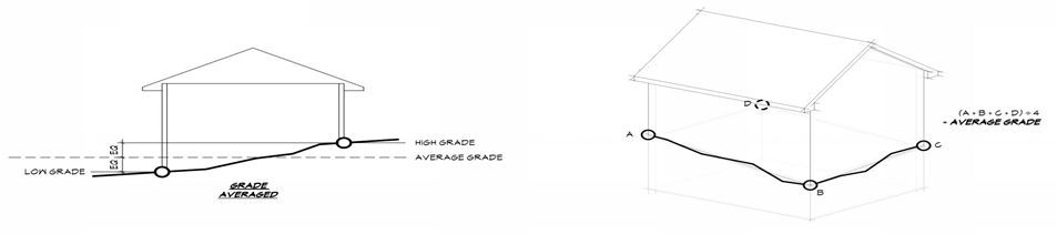
HABITABLE – Any room designed and used for living, sleeping, eating, cooking, or combinations thereof. The following are not to be considered habitable: bathrooms, toilet compartments, closets, halls, storage rooms, unfinished basements, laundry and utility rooms, garages, and similar areas.
HEALTH CARE FACILITIES – General and specialized hospitals and associated clinics providing health related services and involving the overnight or long-term stay of patients.
HEALTH/FITNESS CENTER – A business establishment where members or nonmembers use equipment or space for the purpose of physical exercise.
HEIGHT, BUILDING – The vertical distance between the finished grade of the building and the highest point of the roof.
HEIGHT, FENCE – The vertical distance between the average height of the primary part of the fence and the finished grade. Ornamental and decorative designs and fence posts may extend a maximum of eighteen (18) inches beyond the maximum Fence Height.
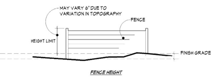
HEIGHT, SIGN – See, Article 15.
HOME DAY-CARE FAMILY, LARGE – See, DAY-CARE HOME, LARGE FAMILY.
HOME DAY-CARE FAMILY, SMALL – See, DAY-CARE HOME, FAMILY SMALL.
HOME OCCUPATION – An accessory use which is an activity, profession, occupation, service, craft, or revenue-enhancing hobby conducted by a person on the same premises as their principal place of residence which is clearly subordinate and incidental to the use of the premises for residential purposes. Home occupations may include, but not limited to, home offices for insurance agents, financial planners, real estate agents, consultants, lawyers, architects, engineers, accountants, or other similar professional services, sewing, tailoring, teaching of music, dance lessons, or tutoring, or other similar uses that do not change the character of the residential neighborhood. Family Day Care Homes, Types A and B shall not be considered to be home occupations and shall be treated as permitted and conditional use as listed in the applicable zoning district.
HOME OCCUPATION, MAJOR – A Home Occupation that complies with Section 17.11(c).
HOME OCCUPATION, MINOR – A Home Occupation that complies with Section 17.11(d).
HOTEL – An establishment consisting of a group of attached or detached living or sleeping units with bathroom and closet space, located on a single lot, and designed for use by transient automobile travelers. A hotel furnishes customary services such as housekeeper service and laundering of linens, telephone, secretarial or desk service and the use of furniture. Ingress and egress to and from all rooms is made through an inside lobby. Sleeping accommodations are available only for a temporary rental occupancy by transient persons for no more than thirty (30) days at one time.
HOTEL, BOUTIQUE – A Hotel with less than fifty (50) rooms that is located in a pedestrian oriented business area. These Hotels typically have a strong artisan sense and focus on the design of the building and rooms.
IMPERVIOUS SURFACE – All areas of a lot that have been or are proposed to be paved and/or covered with buildings and materials that do not readily and freely absorb and/or allow water to penetrate, including, but not limited to, concrete, asphalt, rooftop, blacktop, brick, blocks, and pavers.
IMPROVEMENTS – Any addition to the natural state of land which increases its value or utility, including buildings, street pavements, sidewalks, crosswalks, water mains, sanitary sewers, landscaping, street lighting, street trees, public utilities, paved parking areas, and other appropriate items.
IMPROVEMENTS, SITE – The Improvements made to the land outside the exterior limits of a structure or structures.
IMPROVEMENTS, PUBLIC – All Improvements financed entirely or in part by public funds or which have been dedicated to public use by plat, easement, or deed of transfer.
INDUSTRIALIZED UNIT – A building unit or assembly of closed construction fabrication in an off-site facility, which is substantially self-sufficient as a unit or as part of a greater structure, and that requires transportation to the site of intended use, including units installed on the site as independent units, as part of a group of units, or incorporated with standard construction methods to form a completed structural entity but does not include a Permanently Sited Manufactured Home or Mobile Home as defined in this Code.
INSTITUTIONAL USES – Those uses organized, established, used, or intended to be used for the promotion of public, civic, educational, charitable, cultural, or social or philanthropic activity and include but are not limited to art galleries, art studios, libraries, etc.
JUNK YARDS AND SCRAP METAL PROCESSING FACILITIES – An establishment or place of business that is maintained or operated for the purpose of storing, keeping, buying, selling or exchanging old or scrap copper, brass, rope, rags, trash, waste, batteries, paper, rubber, iron, steel, or other old or scrap materials and where such business or operation is not completely conducted within an enclosed building.
KENNEL, AGRICULTURAL – Any Building or Structure, including the surrounding fenced land, used for the breeding, care (excluding Animal Service Facilities) and/or the raising of domesticated dogs and/or cats for let, hire, board, training, housing, grooming, and/or other Use on a commercial basis for compensation. Said Use is an Agricultural Use under Section 519.01 of the Ohio Revised Code and is considered animal husbandry. Animal Service Facilities or Boarding Kennels shall not be construed to be an Agricultural Kennel under this definition.
KENNEL, BOARDING – Any Building or Structure, including the surrounding fenced land, used for the care and board of five (5) or more domesticated dogs or cats more than four (4) months of age that is open to the public for let, hire, board, training, housing, or grooming on a commercial basis for compensation. The function of the business is not the breeding or raising of dogs or cats.
LANDSCAPE/HARDSCAPE BUSINESS – A place where employees are housed and/or vehicles, machinery, and materials such as trees, shrubs, flowers, or other living vegetation, as well as irrigation systems, stone, brick pavers or other non-living components of a landscape design are stored. Typically, workers are dispatched from this site and said materials are transported to another location for installation.
LANDSCAPE PLAN – A plan that demonstrates how a proposal will adequately enhance the principal building and site; maintain existing trees and natural markings to the extent possible; buffer adjacent incompatible uses; break up large expanses of pavement with natural material; and provide appropriate plant materials for the buildings, site, and climate.
LANDSCAPING – The improvements of a lot with grass, shrubs, trees, and other vegetation and/or ornamental objects.
LEGAL DESCRIPTION – The geographical description of real estate that identifies the precise location, boundaries, and easements for the purpose of a legal transaction, such as a transfer of ownership. A legal description can include either a metes and bounds description or a subdivision plat.
LIFE CARE RETIREMENT CENTER – A Residential Facility containing dwellings designed for and principally occupied by senior citizens in a planned retirement community which includes a residential complex, an activity or community center, and a medical or nursing facility which is licensed by the State of Ohio as an Intermediate Care Facility or a Skilled Nursing Center.
LOADING SPACE, OFF-STREET – An off-street space or berth on the same lot with a building or contiguous to a group of buildings, for the temporary parking of a commercial vehicle while loading or unloading merchandise or materials, and which abuts upon a street, alley, or other appropriate means of access.
LOGISTICS – A large building where material, products, or other manufactured goods are acquired, stored, and transported to their final destination. There is no production, processing, assembling, or packaging of products or materials in these buildings.
LOT – A division of land separated from other divisions for purposes of sale, lease, or separate use, described on a recorded subdivision plat, recorded map or by metes and bounds.
LOT, CORNER – A lot situated at the intersection of two streets, or which fronts a street on two or more sides forming an interior angle of less than 135 degrees. (Also see LOT LINE, FRONT)
LOT, COVERAGE – The total area of those portions of a lot that are covered by a building or structures, paved areas, and other impervious surfaces.
LOT, INTERIOR – A lot that abuts no more than one street and that fronts a street on not more than one side.
LOT, MINIMUM AREA – The area of a lot computed exclusive of any portion of the right-of-way or any public thoroughfare.
LOT LINE – A line bounding or demarcating a plot of land or ground. May also be referred to as a Property Line.
LOT LINE, FRONT – The property line fronting a public roadway right-of-way. For purposes of a corner lot, both property lines abutting a public right-of-way shall be considered a front lot line (See, Section 7.06).
LOT LINE, REAR – The lot line that is opposite the front lot line and farthest from it.
LOT LINE, SIDE – The lot line running from the front lot line to the rear lot line. This line is also the line dividing two interior lots.
LOT OF RECORD – Any lot or parcel of land that was lawfully created by a subdivision plat of record or by a metes and bounds description and recorded in the County Recorder’s Office prior to the effective date of this Resolution.
LOT WIDTH – The width of a lot at the building line measured at right angles to its depth.
LUMBERYARD – A building where bulk supplies of lumber and other building materials are stored, offered, or kept for retail sale and may include storage inside of the building. Any components of this use that include the outdoor storage of said materials shall all within the definition of an outdoor service facility.
MACHINE SHOP – A facility performing cutting, grinding, turning, honing, milling, deburring, lapping, electrochemical machining, etching, or other similar operations.
MAKER SPACE, LARGE – A facility that is 5,000 square feet or larger and serves as shared co-working space for independent craftsmen to produce woodwork, furniture, pottery, glass, or other related items. It may also provide tools, equipment, and materials for shared use. The facility can also have shared office space. The facility may be used to hold classes or workshops as a secondary
function.
MAKER SPACE, SMALL – A facility that does not exceed 5,000 square feet that is utilized for the preparation, display, and sale of individually crafted artwork, jewelry, furniture, sculpture, pottery, glass, woodworking, or other related items. It may also provide tools, equipment, and materials for shared use. No odor, fumes or excess noise may be produced at the facility. The facility may be used to hold classes or workshops as a secondary
function.
MANEUVERING AISLE – A paved area in an off-street parking lot or loading area which provides access to parking, stacking, or loading spaces, exclusive of driveways and is used for and/or is necessary for turning, backing, or driving forward a motor vehicle into such parking space. This area is not used as space for the parking or storage of motor vehicles or for loading or unloading.
MANUFACTURED HOME – A building unit or assembly of closed construction fabricated in an off-site facility, which conforms with the federal construction and safety standards established by the Secretary of Housing and Urban Development under the “Manufactured Housing Construction and Safety Standards Act of 1974” and that has a label or tag permanently affixed to it certifying compliance with all applicable federal construction and safety standards.
MANUFACTURED HOME COMMUNITY – Any tract of land upon which three (3) or more manufactured homes used for habitation are parked, either free of charge or for revenue purposes, and include any roadway, building, structure, vehicle, or enclosure used or intended for use as a part of the facilities of such park. A tract of land which is subdivided, and the individual lots are not for rent or rented but are for sale or sold for the purpose of installation of manufactured homes on the lots is not a manufactured home park, even though three (3) or more manufactured homes are parked thereon, if the roadways are dedicated to the local government authority. Manufactured home park does not include any tract of land used solely for the storage or display for sale of manufactured homes.
MANUFACTURED HOME, PERMANENTLY SITED – A manufactured home, as defined herein, that meets all the following criteria:
(a) The structure is affixed to a permanent foundation such as masonry or concrete and is connected to appropriate facilities;
(b) The structure, excluding any addition, has a width of at least twenty-two (22) feet at one point, a length of at least twenty-two (22) feet at one point, and a total living area of at least nine hundred (900) square feet, excluding garages, porches, or attachments;
(c) The structure has a minimum three to twelve (3:12) roof pitch, conventional residential siding, and a six (6) inch minimum eave overhang, including appropriate guttering.
(d) The structure was manufactured after January 1, 1995;
(e) The structure is not located within a manufactured home park; and
(f) Otherwise complies with the Manufactured Housing Construction and Safety Standards Act of 1974 and has a label or tag permanently affixed to it, certifying compliance with all applicable federal construction and safety standards.
MANUFACTURING – Any industry that makes products from raw materials using manual labor or machinery. This definition also includes the compounding, processing, assembling, and packaging of goods.
MAUSOLOEUM – A holding place for embalmed human remains.
MEDICAL MARIJUANA – Marijuana that is cultivated, processed, dispensed, tested, possessed, or used for a medical purpose.
MIXED-USE BUILDING – Mixed-use buildings must have dwelling units on the upper floors and have commercial uses on the ground floor and are generally part of a Mixed-Use Development.
MIXED-USE DEVELOPMENT – A development that includes a mix of compatible uses such as retail, office, entertainment and various types of Multi-Family and Townhome Buildings or Mixed Use Building residential dwellings, and where these uses are developed at appropriate densities to allow them to be properly integrated in a pedestrian friendly manner to create a walkable community.
MOBILE HOME – A building unit or assembly of closed construction that is fabricated in an off-site facility, is more than thirty-five (35) body feet in length, or, when erected on site, is three hundred twenty (320) or more square feet, which is built on a permanent chassis and is transportable in one (1) or more sections, and does not qualify as a Permanently Sited Manufactured Home or Industrialized Unit as defined in this Code. A Mobile Home shall not be considered as a single-family detached dwelling for the purposes of this Code.
MONOPOLE – A support structure constructed of a single, self-supporting hollow metal tube securely anchored to a foundation.
MOTEL – An establishment consisting of a group of attached or detached living or sleeping units with bathroom and closet space, located on a single lot, and designed for use by transient automobile travelers. A motel furnishes customary services such as housekeeper service and laundering of linens, telephone, secretarial or desk service and the use of furniture.
MOTOR VEHICLE – A passenger vehicle, truck, tractor, tractor – trailer, trailer, boat recreation vehicle, semi-trailer, or any other vehicle propelled or drawn by mechanical power.
MUNICIPAL SERVICES – Any building, area and appurtenances owned and operated by the Township for the purposes of road and maintenance services, providing water, wastewater, or transportation services.
MURAL – See, Sign, Wall Display/Mural.
MURAL, GHOST – A type of sign that has a primary purpose of displaying an historical advertisement painted directly on the exterior of a structure.
MURAL, ORIGINAL ART – A type of wall display that has a primary purpose of displaying an original work of visual art produced by hand that is tiled or painted directly upon directly to an exterior wall of a structure. Original Art Mural does not include:
a) Mechanically produced or computer-generated prints or images, including, but not limited to, digitally printed vinyl;
b) Murals containing electronic or mechanical components; or
c) Changing mural images.
MURAL, VINTAGE ART – A type of wall display that has a primary purpose of displaying an original work of visual art produced by hand that was tiled, painted directly upon, or affixed directly to an exterior wall of a structure prior to the date of adoption of this Code.
MULTI-FAMILY BUILDING – A building that is designed for and used exclusively for four or more dwelling units.
NATURAL/TRADITIONAL CEMETERY – A cemetery that does not accept embalmed human remains.
NEW RESIDENTIAL MAJOR SUBDIVISION – The new construction of an individual single-family home through a subdivision.
NONCONFORMING STRUCTURE – Any building or structure lawfully existing on the effective date of these regulations or amendment thereto, which does not conform to the development standards of the district in which it is located.
NONCONFORMING USE – Any use that was lawfully conducted within any building or on any land on the effective date of these regulations or amendment thereto but is not listed as a permitted use of the district in which it is located.
NURSING HOME – A residential health care facility, licensed by the State of Ohio, which provides institutional lodging, nursing care, personal care, and supervision to aged, chronically ill, physically infirm. or convalescent patients who are not related to the owner or administrator of the facility.
ODOT – The Ohio Department of Transportation.
OFFICE, ADMINISTRATIVE, BUSINESS, MEDICAL OR PROFESSION, LARGE – A building that is 5,000 gross square feet or larger in area and includes a set of rooms or tenant spaces used for commercial, professional, medical, or bureaucratic work.
OFFICE, ADMINISTRATIVE, BUSINESS, MEDICAL OR PROFESSION, SMALL – A building that is less than 5,000 gross square feet in area and includes a set of rooms or tenant spaces used for commercial, professional, medical, or bureaucratic work.
OFF-STREET PARKING GARAGE – A public or private structure that is principally utilized for the parking or storage of motor vehicles to meet the minimum parking requirements in this Zoning Resolution.
OPEN SPACE – An area required to be reserved under this Code for passive or active recreational purposes, an area for conservation of natural resources, reserved space for future school buildings, or some other similar green space. Such open space may include any required central green space utilized for the community. That part of a zoned property, including courts or yards, which are open and unobstructed from its lowest level to the sky, is accessible to all tenants upon the zoning property. Open Space shall be limited to terrestrial features and shall not include ponds, stormwater retention facilities, or other water features.
OUTDOOR BICYCLE STORAGE SPACE – Any parking space for a bicycle located within a property and wholly off any street, alley, or sidewalk.
OUTDOOR BICYCLE STORAGE SPACE, BICYCLE RACK – An object that houses multiple Outdoor Bicycle Storage Spaces. Each individual Bicycle Rack cannot have a height greater than three (3) feet and cannot have a length greater than six (6) feet.
OUTDOOR RECREATION FACILITY – An area that is not fully enclosed by walls and a roof which includes, but not limited to, uses such as athletic fields, parks, (excluding neighborhood parks) court sports, tracks, swimming pools, golf related activities, and similar outdoor recreation uses.
SMALL, OUTDOOR RECREATIONAL FACILITY – Less than 5,000 square feet.
LARGE, OUTDOOR RECREATIONAL FACILITY – 5,000 square feet or larger.
OUTDOOR SEASONAL BUSINESS – A use that is conducted on a temporary basis and is outside of a fully enclosed building. Such uses shall include, but not limited to, holiday tree sales, pumpkin sales, sidewalk sales, etc.
OUTDOOR SERVICE FACILITY – An area that is not fully enclosed by solid walls and a roof and where services are rendered or goods are permanently displayed, sold, or stored. For the purposes of this Code, outdoor service facilities include, but not limited to, restaurant patios, outdoor storage areas, and garden stores. This definition shall not include any use classified as an Outdoor Seasonal Business, as defined herein.
OWNER – Owner of record according to records contained in the County Recorder’s Offices.
OVERLAY ZONE – Zoning Districts that extend on top of more than one base Zoning District and are intended to protect certain critical features and resources. Where the standards of the Overlay Zone and base Zoning District are different, the more restrictive standards shall apply.
PARCEL – A piece of real estate described by metes and bounds in the deed of the land and recorded in the office the county recorder.
PARK, COMMUNITY OR REGIONAL – A park that is twenty (20) acres or larger and designed to service a larger region beyond a specific neighborhood and may include playground apparatus and other space for active recreational purposes, along with some areas for passive use.
PARK, NEIGHBORHOOD – A park that is up to twenty (20) acres in size, serving an area one to two miles in diameter and serving a population of less than 5,000 persons. Neighborhood parks are typically designed to service a specific neighborhood area and may include playground apparatus and other space for active recreational purposes, along with some areas for passive use.
PARKING AISLE – The traveled path through an off-street parking lot or facility between one or two rows of parked vehicles.
PARKING BAY – A row of parking spaces typically separated by a parking island, or some other feature used to break up large spams of asphalt used for the parking surface.
PARKING AREA – An open area other than a street or other public way that is used for the parking of motor vehicles.
PARKING SPACE, OFF-STREET – Any parking space located wholly off any street, alley, or sidewalk, either in an enclosed building or on an open lot and where each parking space conforms to the standards as specified in this Code.
PERMANENT SUPPORTIVE HOUSING – Community-based, long-term housing, and supportive services, as appropriate, for homeless individuals with disabilities.
PERMITTED USE – A use that is permitted within a District that is allowable by a matter of right when designated as such in a District, provided said use complies with all applicable setback and development standards and is issued a Zoning Permit from the Zoning Inspector, or their designee.
PERSONAL SERVICE – Uses that primarily provide services to a person or provide for the care and maintenance of personal goods. Such uses include, but not limited to, beauty shops, barber shops, salons, shoe repair shops, tailoring services, or garment repair services. This includes laundry or dry cleaning drop off/pick up services, but the process of dry cleaning is not included in this definition.
PICK-UP OR BANKING WINDOW – A window used to pick up food, a prescription or other another similar product, parcel pick up, or where banking or financial services are conducted without a patron needing to exit their vehicle. Food orders and prescriptions are typically placed ahead of time online via the web or mobile device, and these windows are typically not utilized for placing and waiting for orders on site.
PLACES OF ASSEMBLY, LARGE – Any facility or business where 300 or more individuals gather to participate or observe programs or services or assemble for social purposes. This includes public halls, theaters, worship facilities, and other similar meeting facilities.
PLACES OF ASSEMBLY, SMALL – Any facility or business where fewer than 300 individuals gather to participate or observe programs or services or assemble for social purposes. This includes public halls, theaters, worship facilities, and other similar meeting facilities.
PLANTS, ASPHALT – A stationary source that manufactures asphalt concrete by heating and drying aggregate and mixing asphalt cements. This includes any combination of the following:
Dryers;
Systems for screening;
Handling;
Storing and weighing dried aggregate;
Systems for loading, transferring, and storing mineral filler;
Systems for mixing;
Transferring and storing asphalt concrete; and
Emission control systems within a stational source.
PLANTS, CONCRETE – The production of concrete that uses a manufacturing process involving the mixing of aggregates, sand, water, cement, and/or other components. This use also includes the stockpiling of bulk materials required for the process and storage of the required equipment used in the operation.
PORCH, ENCLOSED – An indoor patio with walls and a roof for shelter.
PORCH, OPEN-AIR – An outdoor patio that is not enclosed with either a wall or roof.
PORTABLE HOME STORAGE UNIT – Any assembly of materials which is designed, constructed, or reconstructed to make it portable and capable of movement from one site to another and designed to be used without a permanent foundation. Such structures are typically utilized for temporarily storing household goods or other such materials on a residential property.
PRESERVE OR PRESERVATION – The process, including maintenance, of treating an existing building to arrest or slow future deterioration, stabilize the structure, and provide structural safety without changing or adversely affecting the character or appearance of the structure.
PRIVATE CLUB OR LODGE – A nonprofit association of persons, who are bona-fide members paying annual dues, which owns, hires, or leases a building or portion thereof, and the use of such premises is restricted to members and their guests. It shall be permissible to serve food and meals on such premises provided that adequate dining room space and kitchen facilities are available. The sale of alcoholic beverages to members and their guests shall be allowed in conjunction with the operation of a dining room, for the purpose of serving food and meals, though such beverages may be served in a separate room or rooms, and provided that such sale of alcoholic beverages complies with applicable local, state, and federal laws.
PRIVATE LANDING STRIP – A long flat piece of land from which private aircraft can take off and land that is properly licensed by the Federal Aviation Authority or applicable agency. It can be constructed of either grass or pavement.
PRIVATE FAMILY SWIMMING POOL – See, Swimming Pool, Private Family.
PROPERTY LINE – A line bounding or demarcating a plot of land or ground. May also be referred to as a Lot Line.
PUBLIC PROTECTION FACILITY – A facility operated by a public agency for the purposes of public safety including, but not limited to, fire stations, police stations, public safety dispatch facilities, civil defense, storm shelters, and other similar uses.
RECONSTRUCTION – The act or process of depicting, by means of new construction, the form, features, and detailing of a non-surviving site, landscape, building, structure, or object for the purpose of replicating its appearance at a specific period of time and in its historic location.
REHABILITATION – The process of returning a property to a state of utility, through repair or alteration, which makes possible an efficient contemporary use while preserving those portions and features of the property which are significant to its historic, architectural, and cultural values.
RESEARCH AND DEVELOPMENT – A use where individuals are employed to search for knowledge and test processes that might be used to create new technologies, products, services, or systems.
RESIDENTIAL FACILITY – A publicly or privately operated home or facility that is further categorized as:
RESIDENTIAL FACILITY CLASS 1 – A facility that provides accommodations, supervision, personal care services, and mental health services for one or more unrelated adults with mental illness or one or more unrelated children with adolescents with severe emotional disturbances.
RESIDENTIAL FACILITY CLASS 2 – A facility that provides accommodations, supervision, and personal care services to any of the following:
a) One (1) or two (2) unrelated persons with mental illness;
b) One (1) or two (2) unrelated adults who are receiving payments under the residential state supplement program; or
c) Three (3) to sixteen (16) unrelated adults.
Residential facilities exclude hospitals, facilities licensed under ORC Section 5123.19, an institution subject to certification under ORC Section 5102.03, hospice care programs, nursing homes, residential care facilities, homes for the aging, a facility operating an opioid treatment program, a terminal care facility for the homeless, a facility approved exclusively for the placement and care of the veterans per Section 104(a) of the Veterans Health Care Amendments of 1983, or the residence of a relative or guardian of a person with mental illness.
RESIDENTIAL FACILITY, LARGE – Any facility licensed as a Class 2 Residential Facility per ORC Section 5119.34 and provides accommodations and personal care services to six to sixteen unrelated persons (See, ORC Section 5119.341).
RESIDENTIAL FACILITY, SMALL – Any facility licensed as a Class 2 Residential Facility per ORC Section 5119.34 and provides accommodations and personal care services to one to five unrelated persons (See, ORC Section 5119.341).
RESIDENTIAL-OFFICE, ADMINISTRATIVE, BUSINESS, AND MEDICAL – A Small Office for Administrative, Business, Medical, or Professional Services, as defined in this section but located within a structure that was existing at the time of the effective date of this Code.
RESIDENTIAL-RETAIL – A Small Business Retail, as defined, in this section but located within a structure that existed at the time of the effective date of this Code.
RESIDENTIAL TREATMENT FACILITY – A Residential Facility – Class 1 (ORC Section 5119.34) providing diagnostic or therapeutic services, counseling, or treatment and long-term room and board in a highly structured environment for its residents for alcoholism, drug abuse, or behavioral and/or mental disorders.
RESPONSIBLE PARTY – The owner of the property as determined by the County Auditor’s Tax List, the agent of the property owner authorized to be responsible for the premises, or the occupant of the property.
RESTAURANT – An establishment which offers food and/or drinks to the public, guests, or employees. The food may be prepared and consumed either on or off site.
RIGHT-OF-WAY – A strip of land occupied or intended to be occupied by transportation facilities, public utilities, street drainage ditches or other special public uses.
SCHOOL, HIGH SCHOOL – A public or private institution providing secondary education prior to students starting college or obtaining a job. It typically includes grades nine through twelve (9-12).
SCHOOL, POST-SECONDARY – A public or private institution providing educational or training services to individuals who have completed high school.
SCHOOL, PRIMARY, INTERMEDIATE, OR MIDDLE – A public or private institution providing educational services to children in kindergarten through the eighth grade.
SCHOOL, TECHNICAL – A secondary or post-secondary school that provides designed training to students for a specific job or skilled trade.
SELF SERVICE STORAGE FACILITY – An individual compartment or stall used for the storage of customer’s goods or wares.
SETBACK – A required distance between a lot line and a principal structure established by the Zoning District in which the principal structure is located.
SETBACK, AVERAGE FRONT – The distance between a front lot line and principal building that is established by averaging the front setbacks of two existing structures on adjacent lots. In no case shall an average front setback exceed any applicable maximum setback requirement.
SETBACK, MAXIMUM – The largest distance permitted between a lot line and a principal structure. The Zoning Inspector shall not administratively approve the location of a principal structure that is more than this required distance.
SETBACK, MINIMUM – The smallest distance permitted between a lot line and a principal structure established by the Zoning District in which the principal structure is located. The Zoning Inspector may not administratively approve the location of a principal structure that is less than this required distance but may administratively approve the location of a principal structure that is more than this required distance. In such cases, the area between the required minimum setback and the principal structure is a “Yard” space, as defined, in this Code.
SEXUAL CONDUCT – Acts of sexual intercourse and masturbation within their ordinary meanings; erotic touching of oneself or another.
SHORT-TERM RENTAL – Renting a home, or a space in a home, with five guestrooms or less that is reserved or rented wholly or partly for compensatory fee for less than thirty (30) consecutive days.
SHORT-TERM RENTAL, HOSTED – A short-term rental where an owner of the home, or space in a home, shares the premises with the tenant(s).
SHORT-TERM RENTAL, UNHOSTED – A short-term rental where an owner of the home, or space in a home, does not share the premises with the tenant(s).
SHOOTING RANGE, INDOOR – The use of a structure for archery and/or the discharging of firearms for the purposes of target practice or temporary competitions.
SHOOTING RANGE, OUTDOOR – The use of land for archery and/or the discharging of firearms for the purposes of target practice, skeet and trap shooting, mock war games, or temporary competitions, such as turkey shoots. Excluded from this use type shall be general hunting and unstructured and nonrecurring discharging of firearms on private property with the property owner’s permission.
SIGHT TRIANGLE – The triangular area formed by a diagonal line connecting two points located on intersecting street rights-of-way or a right-of-way and the edge/curb of a driveway (See, Section 17.22).
SIGN – Any device for visual communication which is designed, intended, or used to convey a message, advertise, inform, or otherwise direct attention to a person, institution, organization, activity, business, place, object, or product. Signs erected by the local, state, or federal government for the purposes of discharging in any normal governmental function, such as traffic control or safety, are likewise excluded from the regulations of this Article. This definition includes all signs visible from any public right-of-way or adjacent property, including interior signs oriented towards the exterior façade of any Building or structure that includes any name, number, symbol, identification, description, display, illustration, object, graphic, sign structure, or part thereof, which directs attention to any object, product, place, activity, person, institution, organization, or business.
SIGN, ANIMATED – Any sign that uses movement or change of artificial and natural lighting or noise to depict action or create a special effect or scene.
SIGN, BILLBOARD – A type of free-standing sign that is mechanically produced or computer-generated prints or images, including, but not limited to, digitally printed vinyl and/or 3D printed elements, which are typically attached or affixed to a pole or other type of free-standing support. Said signs are greater than 200 square feet.
SIGN, DIRECTIONAL – Any sign which provides direction or guidance to help navigate a person to a specific location of an institution, organization or business, or property.
SIGN, ENTRY FEATURE – A sign intended to provide the identity of a residential development or commercial development with more than one lot or tenant.
SIGN, FLASHING – A sign or graphic which in any manner, as a whole or in part, physically changes in light intensity or gives the appearance of such change.
SIGN, FREESTANDING – A sign erected on a pole, poles, pillars, or posts (pylon sign) or any monument type sign (sign with a base) which is wholly independent of any building or support.
SIGN, GAS INFLATABLE – Any device which is capable of being expanded by any gas and is typically tethered or otherwise anchored to the ground or structure and used on a permanent or temporary basis to attract attention to a product, event, or business.
SIGN, GROUND MOUNTED – A type of free-standing sign that is supported by a monument style base and does not include any poles, pillars, or posts.
SIGN, PERMANENT – A sign intended to be erected, displayed, or used, or in fact which is used for time period in excess of thirty (30) days within any 180-day period.
SIGN, PROJECTING – A sign which extends outward perpendicular to the building face.
SIGN, PYLON – A type of free-standing sign that is supported by pole(s), pillars, posts, or other free-standing support and is less than 200 square feet.
SIGN, ROOF – Any sign erected upon or completely over the roof of any building.
SIGN, TEMPORARY – A display, banner, or other advertising device constructed of cloth, canvas, fabric, wood, or other temporary material, with or without a structural frame, including, but not limited to, portable signs, feathered flags, development signs, community event signs, garage sale signs, real estate signs, sandwich type signs, sidewalk or curb signs, and balloon or other air or gas filled figures.
SIGN, TRAILER – A sign that is constructed on a chassis intended for the mounting of wheels, thereby permitting the sign to be moved forward.
SIGN, WALL – A wall display that is less than 125 square feet.
SIGN, WALL DISPLAY/MURAL – A sign attached to a building face, with the exposed face thereof in a plane parallel to the plane of the wall. Wall signs include messages, graphics and other designs painted along with any letters or numerals mounted directly on buildings or awnings.
SIGN, WINDOW – A sign, graphic, poster, symbol, or other identification which is physically affixed to or painted on the glass or other structural component of the window.
SOLAR, ARRAY – A mechanically integrated assembly of modules or panels with a support structure and foundation, tracker and other components as required to form a direct-current power producing unit.
SOLAR ENERGY – Radiant energy (direct, diffused, or reflected) received from the sun at wavelengths suitable for conversion into thermal, mechanical, chemical, or electrical energy.
SOLAR ENERGY SYSTEM (SES) – An energy system that consists of one or more solar collection devices, solar energy-related equipment, and other associated infrastructure with the primary intention of generating electricity, storing electricity, or otherwise converting solar energy to a different form of energy. An SES may generate energy exceeding the energy requirements of a property if it is to be sold back to a public utility under the law.
SOLAR ENERGY SYSTEM, INTEGRATED – An SES where solar materials are incorporated into building materials, such that the two are reasonably indistinguishable, or where solar materials are used in place of traditional building components, such that the SES is structurally an integral part of a house, building, or other structure. An Integrated SES may be incorporated into, among other things, a building façade, skylight, shingles, canopy, light, or parking meter.
SOLAR ENERGY SYSTEM, GROUND-MOUNTED – An SES where an array is mounted on a rack or pole that is ballasted on, or is attached to, the ground.
INTERMEDIATE-SCALE GROUND-MOUNTED SOLAR ENERGY SYSTEM (INTERMEDIATE SCALE SES) – A ground mounted SES with a footprint of between five (5) and fifteen (15) acres.
LARGE SCALE GROUND MOUNTED SOLAR ENERGY SYSTEM (LARGE SCALE SES) – A ground mounted SES with a footprint of more than fifteen (15) acres.
SMALL-SCALE GROUND-MOUNTED SOLAR ENERGY SYSTEM (SMALL SCALE SES) – A ground mounted SES with a footprint of less than (5) acres.
SOLAR ENERGY SYSTEM, ROOF MOUNTED – An SES mounted to the roof of a building or structure. Roof-mount systems are accessory to the primary use of a property.
SPECIFIED SEXUAL ACTIVITIES – Simulated or actual display of human genitals in a state of sexual stimulation or arousal, acts of masturbation, sexual intercourse, sadomasochistic acts, fellatio, or cunnilingus, and fondling or erotic touching of oneself or of one person by another.
START OF CONSTRUCTION – The first placement of permanent construction of a structure (other than a mobile home) on a site, such as the pouring of slabs or footings or any work beyond the state of excavation. Permanent construction does not include land preparation, such as clearing, grading, and filling, nor does it include the installation of streets and/or walkways; nor does it include excavation for a basement, footings, piers or foundations or the erection of temporary forms; nor does it include the installation on the property of accessory buildings, such as garages or sheds not occupied as dwelling units or not as part of the main structure. For a structure (other than a mobile home) without a basement or poured footings, the “start of construction” includes the first permanent framing or assembly of the structure or any part thereof on its piling or foundation. For mobile homes not within a mobile home park or mobile home subdivision, “start of construction” means the affixing of the mobile home to its permanent site. For mobile homes within mobile home parks or mobile home subdivisions, “start of construction” is the date on which the mobile home is to be affixed (including, at a minimum, the construction of streets, either final site grading or the pouring of concrete pads, and installation of utilities) is completed.
STREET – A paved public vehicular right-of-way which provides access to abutting properties from the front.
STREET, ARTERIAL – A Street connecting the Township with outside activity centers and serving as the primary routes through and within the Township. Arterial Streets carry the largest volume of traffic – over 5,000 vehicles per day ADT – usually on a continuous route. Service to the adjacent land is subordinate to the provision of travel service on Arterial Streets.
STREET, MAJOR COLLECTOR – A thoroughfare which carries vehicular traffic from Local Streets to Arterial Streets and is designed to accommodate 1,000-5,000 vehicles per day ADT.
STREET, MINOR COLLECTOR – A thoroughfare which primarily carries vehicular traffic from local street to Major Collector Streets and Arterial Streets and is designed to accommodate 500-1,000 vehicles per day ADT.
STREET, LOCAL – A street on which the majority of the traffic originates or terminates in the abutting properties. These Streets are designed to accommodate up to 500 vehicles per day ADT at low speeds.
STREET, PRIVATE – A strip of privately-owned land providing access to abutting properties.
STREET, PUBLIC – A strip of land providing public access to abutting property, as dedicated to the Township or Delaware County upon a plat which has been duly approved, filed, and recorded in the Delaware County Recorder’s Office.
STRUCTURAL ALTERATION – Any change in the supporting members of a Building, such as bearing walls or partitions, columns, beams or girders, or any increase in the area or cubical contents of a building.
STRUCTURE – Anything constructed or erected, the use of which requires a permanent location on the ground or attached to something having a permanent location on the ground, including outdoor advertising signs, (billboards), and farmers’ street-side stands.
SUBSTANTIAL IMPROVEMENT/ALTERATION – Any repair, reconstruction, or improvement of a structure, the cost of which equals or exceeds fifty percent (50%) of the market value of the structure either before the improvement or repair is started, or if the structure has been damaged and is being restored before the damage occurred. For this definition, “substantial improvement” is considered to occur when the first alteration of any wall, ceiling, floor, or the first other structural part of the building commences, whether that alteration affects the external dimensions of the structure. The term does not, however, include any project for improvement of a structure to comply with existing state or local health, sanitary, or safety Code specifications which are solely necessary to assure safe living conditions, or any alteration of a structure listed on the National Register of Historic Places or a State Inventory of Historic Places provided the alteration will not preclude the structure’s designation as a historic structure.
SUBSTANTIALLY COMPLETE – The stage in which the work, described in the Zoning Permit, is finished to a point that the applicant/owner can occupy or utilize the land or building for its intended purpose.
SWIMMING POOL, COMMERCIAL – A body of water in an artificial or natural receptacle or another container, whether located indoors or outdoors, used or intended to be used for public, semi-public, or private swimming by adults and/or children whether any charge or fee is imposed, operated by an owner, lessee, operator, licensee or concessionaires, exclusive of a Private Family Swimming Pool, as defined herein, and shall include all structures, appurtenances, equipment, appliances, and other facilities appurtenant to and intended for the operation and maintenance of a swimming pool, and also, all swimming pools operated and maintained in conjunction with or by clubs, motels, hotels, apartments and condominiums, and community associations.
SWIMMING POOL, PRIVATE FAMILY – A swimming pool used or intended to be used solely by the owner or lessee thereof and family, and by friends invited to use it without payment of any fee, and normally capable of containing water to a depth at any point greater than three (3) feet.
SWIMMING POOL, TEMPORARY – A pool capable of holding water to a maximum depth of fifty-four (54) inches and is constructed of non-metallic, molded polymeric or fabric walls supported on a rigid frame or by an inflatable ring and entirely on or above ground, and is designed and constructed to be readily disassembled for storage and re-assembled to its original integrity.
TELECOMMUNICATION TOWER – A structure situated on a site used to support antennas and radio or cellular communications equipment. Antennas used by amateur radio operators are excluded from this definition.
TELECOMMUNICATION TOWER, ATTACHED – Any structure that will be attached to a Building or other structure that meets the criteria for a Telecommunication Tower, as defined herein.
TELECOMMUNICATIONS TOWER, FREE STANDING – Any free-standing structure that meets the criteria for a Telecommunication Tower, as defined herein.
TEMPORARY STRUCTURE, CONSTRUCTION TRAILER/OFFICE – Any structure that is not permanent and is located on a construction site for purposes of storing materials and tools or for offices for construction management.
TEMPORARY TENT – See, Section 17.21.
THOROUGHFARE PLAN – The document now or hereafter adopted, which may be considered a component of the Trenton Township Comprehensive Land Use Plan, which sets forth the location, alignment, and/or classification of existing and proposed Streets.
TRANSITIONAL LIVING CENTER – A facility that provides short-term room and board in a supervised living environment utilizing counseling and rehabilitation services for persons with a history of juvenile delinquency, behavioral disorders, alcoholism, or drug abuse.
TREE, LARGE – Any tree species that normally attains a full-grown height above sixty (60) feet.
TREE, MEDIUM – Any tree species that normally attains a full-grown height between thirty (30) and sixty (60) feet.
TREE, SMALL – Any tree species that normally attains a full-grown height of under thirty (30) feet.
TRUCK SERVICE CENTER – A commercial facility which provides refueling, parking, and often ready-made food for motorists and truck drivers. These facilities sometimes also include showers for truck drivers.
UNNECESSARY HARDSHIP – A standard utilized to determine whether a Variance should be granted arising from special conditions of, or involving, the property. The special conditions must be unique to the property and not ordinarily found in the same zoning district. Furthermore, the special conditions must result from the enforcement of this Resolution and not by an action or actions of the property owner, the applicant, or any other person or party who has had control of the property.
USE – The purpose for which a building or land may be arranged, designed, or intended to be occupied or maintained.
VARIANCE – A modification of the strict terms of this Resolution where such modifications will not be contrary to the public interest and, where owing to conditions peculiar to the property and not the result of the action of the applicant, a literal enforcement of this Resolution would result in Unnecessary Hardship. Variances are granted only after the applicant has followed the procedures stated in Section 3.10 of this Resolution.
VEHICLE, CHARGING STATION – The design and construction of a parking space with Electric Vehicle Supply Equipment that supplies electric energy for the recharging of electric vehicles.
VEHICLE, RECREATIONAL – Any motorized or non-motorized vehicle that is used for recreational purposes including, but not limited to, all-terrain vehicles, dune buggies, motor bikes, recreational vehicle trailers, snowmobiles, trail bikes, and various watercraft including canoes, kayaks, boats, and jet skis.
VEHICULAR SALES, EQUIPMENT – An open area or building used for the display, sale or rental of farm, construction, or other similar machinery.
VEHICULAR SALES, MOTORCYLCES – An open area or building used for the display, sale, or rental of new or used motorcycles, and where only incidental repair work is done.
VEHICULAR SALES, NEW AND USED CARS – An open area, other than a street, used for the display, sale, or rental of new or used motor vehicles in operable condition, and where only incidental repair work is done.
VEHICULAR SALES, RECREATIONAL – An open area or building used for the display, sale, or rental of new or used recreational vehicles and where only incidental repair work is done.
WALL, DECORATIVE – An architecturally designed wall that is intended to prohibit public view and provide seclusion, has more than fifty percent (50%) of its vertical surface area closed to light and air, and is not designed for purposes of retaining soil.
WALL, RETAINING – An engineered wall that is designed and intended to support soil laterally so that it can be retained at different levels on the two sides.
WALLSCAPE – A type of wall display that greater than 125 square feet and is mechanically produced or computer generate prints or images, including, but not limited to, digitally printed vinyl and/or 3D printed elements, which are typically attached to the side of a building.
WEDDING VENUE – An event space that may be located in Places of Assembly or tied to an Agritourism Use, as defined herein, to celebrate marriage. For the purposes of this Code, a Wedding Venue tied to an Agritourism Use shall have a heightened standard requiring a minimum Lot Size of twenty (20) acres and therefore require a Conditional Use Permit. This heightened standard is permitted due to not falling under Agritourism regulations per the definition found in ORC 901.80(2).
WIND ENERGY CONVERSION SYSTEM – An energy system consisting of a wind turbine, a tower, and associated control or conversion electronics.
WIND ENERGY CONVERSTION SYSTEM, INDIVIDUAL – A Wind Energy Conversion System consisting of a wind turbine, a tower, and associated control or conversion electronics, which has a single interconnection to the electrical grid, an aggregate rated capacity of not more than 100 kilowatts and is intended to primarily reduce on–site consumption of utility power.
WIND ENERGY CONVERSTION SYSTEM, TOWER – The support structure to which the nacelle and the rotor are attached.
WIND ENERGY CONVERSION SYSTEM, TOWER HEIGHT OF – The distance from the rotor blade at its highest point to the top surface of the tower foundation.
WIND FARM, SMALL – A Wind Energy Conversion System consisting of wind turbine(s), tower(s) and associated control or conversion electronics, which have an aggregate rated capacity of 100kW or more, but less than fifty (50) megawatts and has a single interconnection to the electrical grid. Any Wind Energy Conversion System that is five (5) megawatts or larger shall be reviewed by the Ohio Power Siting Board and shall not be subject to the regulations within this Zoning Code.
YARD – An open space on a lot with a building that is unoccupied and unobstructed by any portion of a principal structure. Fences and other accessory structures may be permitted within a yard as regulated in this Code.
FRONT YARD – The horizontal distance between the right-of-way line and the nearest foundation or structural appurtenance of the principal structure.
REAR YARD – The horizontal distance between the rear lot line and the nearest foundation or structural appurtenance of the principal structure.
SIDE YARD – The horizontal distance between the side lot line and the nearest foundation or structural appurtenance of the principal Building.
ZONING APPEALS, BOARD OF – Means the Board of Zoning Appeals of Trenton Township, Delaware County established in Section 2.05 – Establishment of the Board of Zoning Appeals of this Resolution.
ZONING COMMISSION - The Zoning Commission of Trenton Township, Delaware County, Ohio.
ZONING DISTRICT – Any section of the Zoning Map and/or legal description in which the zoning regulations are uniform.
ZONING INSPECTOR – The authorized representatives appointed by the Trustees to issue Zoning Permits and perform other duties as specified in this Code.
ZONING MAP – A map of the Township that legally denotes the boundaries of the Zoning Districts as they apply to the properties within the jurisdiction. The official zoning map shall be kept on file in the administrative offices.
ZONING PERMIT – A document issued by the zoning administrator authorizing the construction or alteration of a building, structure, or use consistent with this Code.